TALLAHASSEE, Florida — As Hurricane Irma continues its trek through the Caribbean, Floridians prepare for storm’s uncertain landfall.
**UPDATES BELOW**
UPDATE 12 p.m. ET: Another 700k asked to evacuate Florida per the Associated Press
BREAKING: Florida asks another 700,000 to leave ahead of Hurricane Irma; nearly 7 million total urged to evacuate multiple states.
— The Associated Press (@AP) September 9, 2017
UPDATE 10:30 a.m. ET: Computer models show Irma trekking up Florida’s west coast. However, the EURO and GFS show different predictions as the storm enters northern Florida.
Both the GFS and EURO continue to track #Irma up the western coast of Florida, however the GFS takes it to the east suddenly in northern FL. pic.twitter.com/yZOgmImD2w
— Hurricane Tracker App (@hurrtrackerapp) September 9, 2017
UPDATE 9 a.m. ET: ‘LEAVE NOW,’ Florida Governor Tells 5.6 Million Residents in ‘Irma’s’ Path
Breitbart Texas’ Bob Price has the update here.
UPDATE 8:30 a.m. ET: Due to the numerous updates, a new live wire page has been started. Page will continue to be updated here. Previous updates will remain available here.
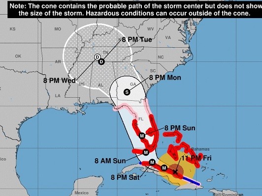
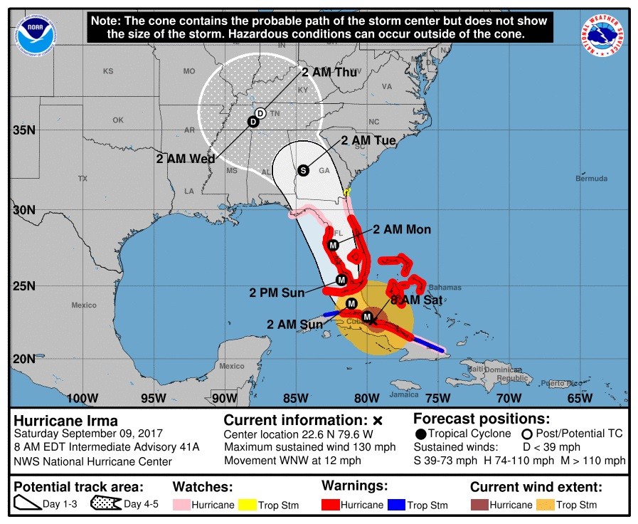
UPDATE 8 a.m. ET: Irma once again a Category 4 hurricane. Winds from within the storm have been reduced to 130 mph.
The National Hurricane Center’s latest advisory has the storm located at 22.6°N 79.6°W, moving west at 12 mph, 225 miles southeast of Miami.
Some of the key updates include the extension of watches and warnings by the National Hurricane Center:
SUMMARY OF WATCHES AND WARNINGS IN EFFECT:
A Storm Surge Warning is in effect for…
* Volusia/Brevard County Line southward around the Florida peninsula
to Chassahowitzka
* Florida Keys
* Tampa BayA Storm Surge Watch is in effect for…
* North of the Volusia/Brevard County Line to the Flagler/Volusia
County line
* North of Chassahowitzka to Suwannee RiverA Hurricane Warning is in effect for…
* Flagler/Volusia County Line southward around the Florida peninsula
to Chassahowitzka
* Florida Keys
* Lake Okeechobee
* Florida Bay
* Cuban provinces of Camaguey, Ciego de Avila, Sancti Spiritus,
Villa Clara, and Matanzas
* Northwestern BahamasA Hurricane Watch is in effect for…
* North of the Flagler/Volusia County Line to Fernandina Beach
* North and west of Chassahowitzka to Indian Pass
* Cuban provinces of Holguin and Las TunasA Tropical Storm Warning is in effect for…
* Cuban provinces of Holguin, Las Tunas, La Habana, and Ciudad de
la HabanaA Tropical Storm Watch is in effect for…
* North of Fernandina Beach to Altamaha Sound
UPDATE 2 a.m. ET: The National Hurricane Center’s latest advisory has the storm located at 22.3°N 78.2°W, moving west at 13 mph, 275 miles southeast of Miami.
UPDATE 12:45 a.m. ET Saturday: 100 mph sustained winds, with 125 mph gusts for Tampa forecasted.
NWS forecast has sustained winds of 100 mph in Tampa w/gusts to 125 mph from Hurricane #Irma. Are folks aware of this?
— Ryan Maue | weathermodels.com (@RyanMaue) September 9, 2017
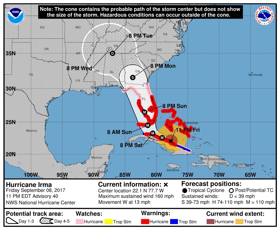
UPDATE 11:30 p.m. ET: Hurricane Irma regains Category 5 status
The National Hurricane Center’s latest advisory has the storm located at 22.1°N 77.7°W, moving west at 13 mph, 300 miles southeast of Miami.
UPDATE 11:15 p.m. Gov. Kay Ivey (R-AL) has issued an emergency declaration for the state of Alabama anticipating Hurricane Irma’s arrival.
Read the declaration here.
Governor Ivey Declares State of Emergency Ahead of Hurricane Irma https://t.co/sXWLjcyOhS
— Governor Kay Ivey (@GovernorKayIvey) September 8, 2017
UPDATE 11 p.m. ET: Jeb Bush on Trump Admin Handling of Hurricanes Irma, Harvey: “I Think They’ve Done Well”
More here.
UPDATE 10:15 p.m. ET: FEMA has established a “rumor control page” to help discern fact from fiction.
We created an #Irma rumor control page to help you verify what’s true and what’s not. Visit it here: https://t.co/nnXuF8Q7E8 pic.twitter.com/ypNwNRlOM0
— FEMA (@fema) September 8, 2017
UPDATE 10 p.m. ET: An estimated 5.6 million people have been asked to evacuate Florida according to the Associated Press ahead of Hurricane Irma.
BREAKING: Officials: 5.6 million people have been asked to evacuate Florida ahead of Hurricane Irma.
— The Associated Press (@AP) September 8, 2017
UPDATE 9 p.m. ET: The National Hurricane Center’s latest advisory has the storm located at 22°N 77.2°W, moving west at 12 mph, 315 miles southeast of Miami.

UPDATE 8 p.m. ET: NBC 6 in Miami has a side-by-side comparison of Hurricane Irma and 1992 Hurricane Andrew. Andrew ended up costing $26.5 billion in damage, the fifth-costliest hurricane in American history.
Here's how Hurricane Andrew and Hurricane Irma significantly differ from one another https://t.co/1UXY21UJjk pic.twitter.com/kGvSGUs4C5
— NBC 6 South Florida (@nbc6) September 8, 2017
UPDATE 7 p.m. ET: The National Hurricane Center’s latest advisory has the storm located at 22.1°N 76.5°W, moving west at 12 mph, 345 miles southeast of Miami.

UPDATE 6 p.m. ET: Computer models showing storm now trending a trek up the west coast of Florida.
All of the hurricane models have shifted west as well in terms of the track of #Irma. Southwest Florida will likely take the landfall. pic.twitter.com/DW9LCQuGje
— Hurricane Tracker App (@hurrtrackerapp) September 8, 2017
UPDATE 4:30 p.m. ET: Tampa Mayor Bob Buckhorn to CNN: “We have never seen a storm like this before in its depth, in its breadth, in its magnitude.”
Tampa Mayor @BobBuckhorn: "We have never seen a storm like this before in its depth, in its breadth, in its magnitude." #HurricaneIrma pic.twitter.com/RG3CbIEmeM
— Michaela Pereira (@Michaela) September 8, 2017
UPDATE 3:30 p.m. ET: Walt Disney World, other theme parks and resorts to close Saturday through Monday for Hurricane Irma.
Florida's theme parks closing as Irma approaches https://t.co/YtPiMJYZKs #FlaPol pic.twitter.com/qVWiMofsXP
— Peter Schorsch (@PeterSchorschFL) September 8, 2017
UPDATE 2:30 p.m. ET: New EURO computer model has Hurricane Irma tracking even further to the west.
The latest run of the EURO tracks #Irma even further west by a bit. This increases the threat for storm surge in southwest Florida. pic.twitter.com/MfFkeeeebV
— Hurricane Tracker App (@hurrtrackerapp) September 8, 2017
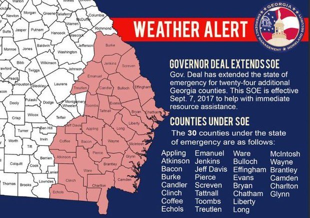
UPDATE 2:15 p.m. ET: Georgia Gov. Nathan Deal has expanded the state of emergency coverage area to now include 30 counties in southeastern Georgia.
UPDATE 2 p.m. ET: The National Hurricane Center’s latest advisory has the storm located at 22°N 76°W, moving west at 14 mph, 380 miles southeast of Miami.

UPDATE 1:30 p.m. ET: Florida airports begin to announce closures ahead of storm’s arrival.
- Miami International Airport: Will close as conditions deteriorate per its website.
- Fort Lauderdale-Hollywood International Airport: Will cease operations at 7:45 p.m. on Friday.
- Palm Beach International Airport: Will suspend operations after last flight departs at 9:04 p.m. on Friday.
- Key West International Airport: Airline operations were suspended on Thursday.
- Orlando-Melbourne International Airport: Will close after the last flight on Saturday.
- Southwest Florida International Airport (Ft. Myers): Urges travelers to consult with their airline.
- Orlando International Airport: “All commercial operations at MCO will cease on Saturday, September 9 at 5:00 p.m.“
- Tampa International Airport: “We will cease commercial airline operations at @FlyTPA at 8 pm Saturday. Check with your airline for details on specific flights.”
- Sarasota-Bradenton International Airport: Remains open, website encourages travelers to check with their airline.
- St. Petersburg-Clearwater International: Closed on Friday “until further notice.”
- Daytona Beach International Airport: “The passenger terminal will close 6 p.m. Saturday, Sept. 9. The last flight of the day will be Delta’s 3:15 p.m. departure. Flights on Sunday are canceled.”
- Gainesville Regional Airport: Urges travelers to check with their airlines.
- Jacksonville International Airport: Encourages travelers to check with their airlines.
- Tallahassee International Airport: Encourages travelers to check with their airlines.
- Destin-Ft. Walton Beach Airport: Expects to remain open through the storm.
- Northwest Florida Beaches Airport (Panama City): Operations are “normal,” suggests travelers check with their airline.
- Pensacola International Airport: Expects to remain open unless impacted directly by the storm.
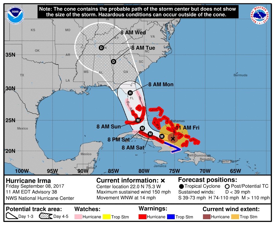
UPDATE: 12 p.m. ET: The National Hurricane Center’s latest advisory has the storm located at 22°N 75.3°W, moving west at 14 mph, 405 miles southeast of Miami.
UPDATE 10:30 a.m. ET: The National Weather Service has created a one-stop website for all things Hurricane Irma.
A one-stop spot for everything #Irma: https://t.co/QyKki8Gjia
— NWS (@NWS) September 8, 2017
UPDATE 9 a.m. ET: Florida newspaper front pages continue to warn residents about Hurricane Irma’s arrival.

Miami Herald, 9/8/17
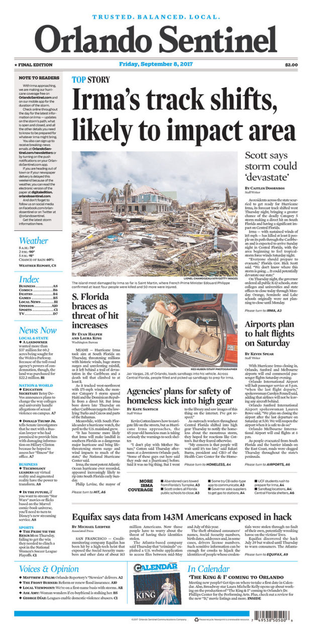
Orlando Sentinel, 9/8/17
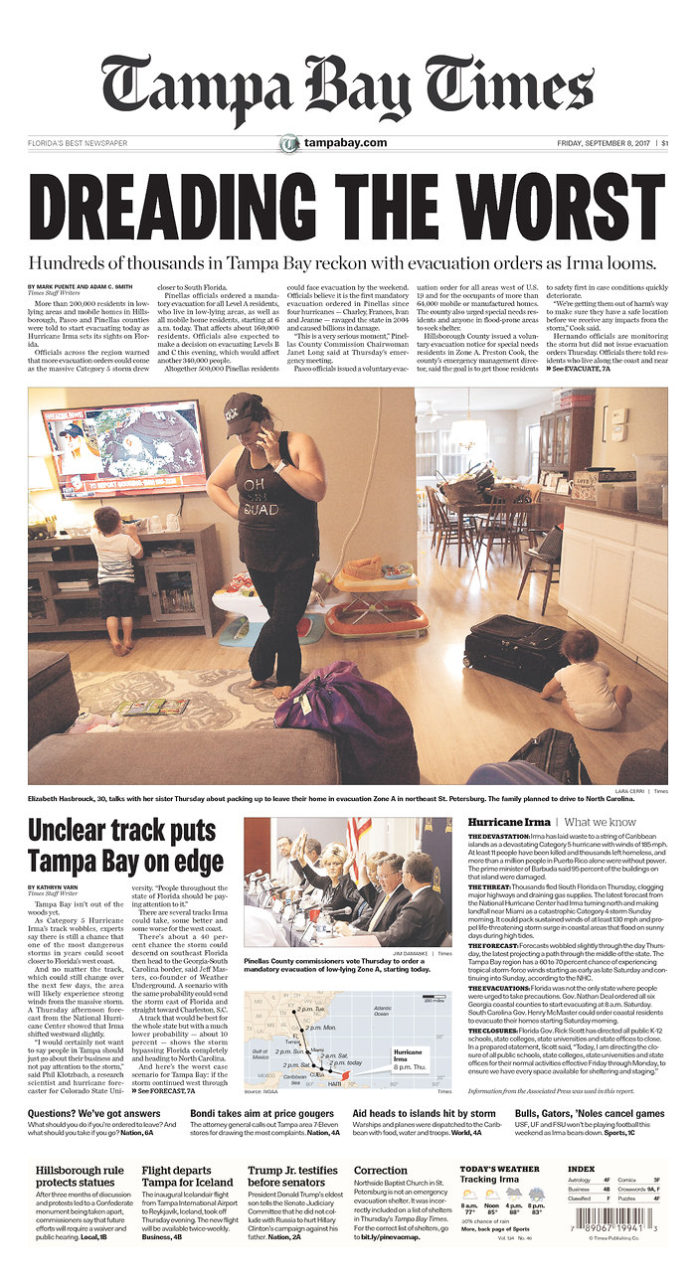
Tampa Bay Times 9/8/17

Jacksonville, FL’s Times-Union, 9/8/17
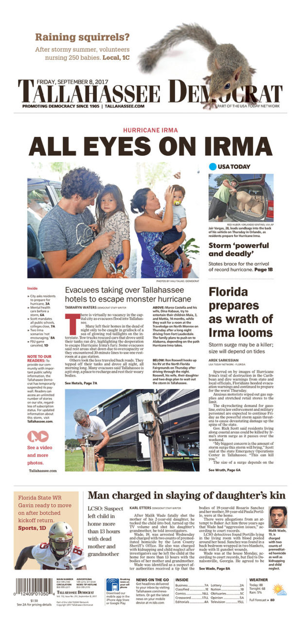
Tallahassee Democrat, 9/8/17
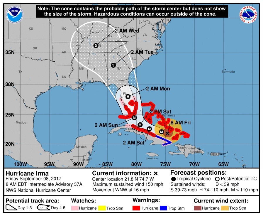
UPDATE 8 a.m. ET: Irma remains a Category 4 hurricane.
The National Hurricane Center’s latest advisory has the storm located at 21.8°N 74.7°W, moving west at 16 mph, 80 miles east of Cabo Lucrecia, Cuba.
UPDATE 7 a.m. ET: Nuclear plants ready for Irma
Politico’s Bruce Ritchie has the story about two of South Florida’s nuclear facilities in the path of the storm — a St. Lucie plant on Hutchinson Island, eight miles southeast of Fort Pierce and at the Turkey Point plant on Biscayne Bay 24 miles south of Miami.
From Politico Florida:
Utility officials said earlier in the week they were prepared to shut down either or both plants if the hurricane threatens, and they were making preparations this week as the storm approached.
“Turkey Point of course will be closed,” [Gov. Rick] Scott said during a news conference in Hialeah.
“I’ve been talking with FPL — they’re all prepared to do it. We’ve preparing both — to close it, and how to reopen it,” he said.
.@insideFPL said they were prepared to shut down either or both nuclear plants if #Irma threatens https://t.co/O4OWMiTkPj pic.twitter.com/bMTDzC2cIb
— POLITICO Florida (@politicofl) September 7, 2017
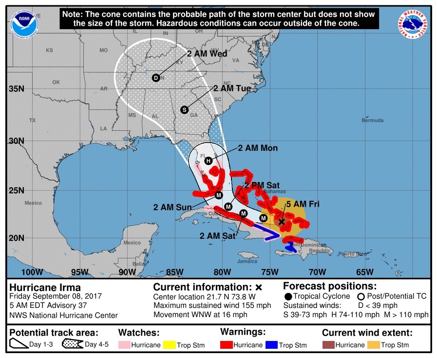
UPDATE 5 a.m. ET Friday: Hurricane Irma now a Category 4 hurricane.
The National Hurricane Center’s latest advisory has placed storm located at 21.7°N 73.8°W, moving west at 16 mph, 55 miles east of Great Inagua Island.
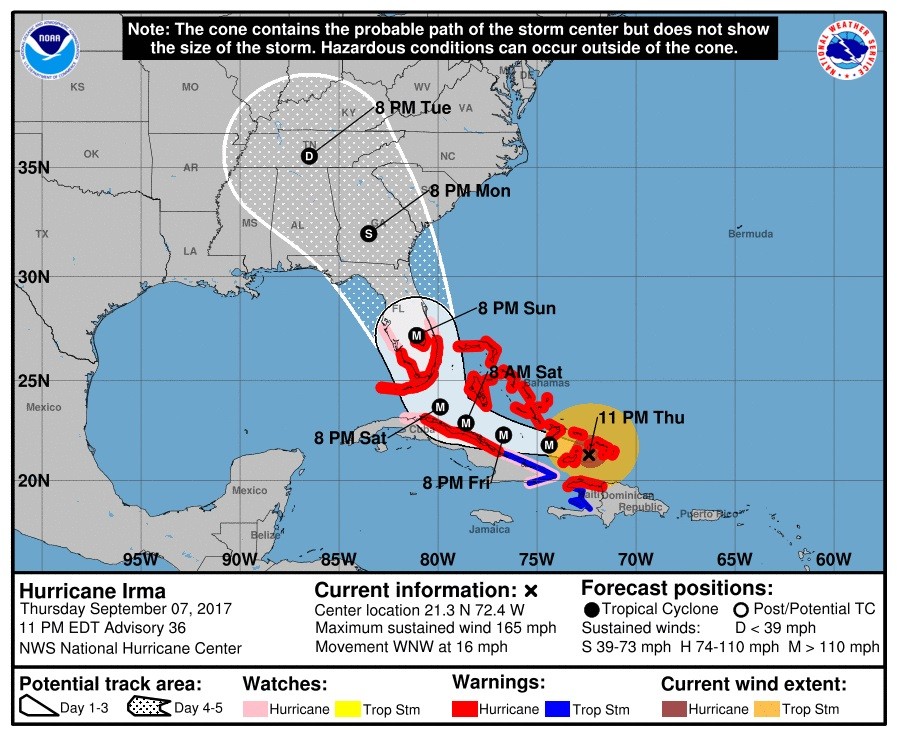
UPDATE 11 p.m. ET: Parts of Florida are now under a hurricane warning.
The National Hurricane Center’s latest advisory has placed storm located at 21.3°N 72.4°W, moving west at 16 mph, 55 miles east of Great Inagua Island.
The hurricane warning area includes from Jupiter Inlet southward around the Florida peninsula to Bonita Beach, as well as for the Florida Keys, Lake Okeechobee and Florida Bay according to the advisory.
A hurricane watch has been extended from north of Jupiter Inlet to Sebastian Inlet and for the west coast of Florida north of Bonita Beach to Anna Maria Island.
Hurricane Warning now in effect for the Florida Keys and surrounding coastal waters. Here is what that means. #Irma #FLKeys #KeyWest #FLwx pic.twitter.com/FXmXWD7CYq
— NWS Key West (@NWSKeyWest) September 8, 2017
UPDATE 10:30 p.m. ET: Man reportedly shot by police at the Miami International Airport according to CBS Miami.
BREAKING: Man shot by police at Miami International Airport @iflymia https://t.co/HD3htonVKc
— CBS4 Miami (@CBSMiami) September 8, 2017
The Miami Herald reported it was described as a “security situation” and law enforcement said it was under control.
The Miami International Airport has been an integral part of the Hurricane Irma evacuation process.
Security incident involving a single suspect & @MiamiDadePD has occurred at MIA. Situation under control. Terminal J is temporarily closed.
— Miami Int'l Airport (@iflymia) September 8, 2017
UPDATE 9 p.m. ET: Gov. Rick Scott has closed all K-12 public schools, state colleges, state universities and state offices per a release posted to the governor’s website.
Statement as follows:
WEST PALM BEACH, Fla. – Today, Governor Rick Scott is directing all public K-12 schools, state colleges, state universities and state offices to close Friday, September 8 – Monday, September 11.
Governor Scott said, “Today, I am directing the closure of all public schools, state colleges, state universities and state offices for their normal activities effective Friday through Monday, to ensure we have every space available for sheltering and staging. Floridians are facing a life-threatening storm in Hurricane Irma, and every family must prepare to evacuate. Our state’s public schools serve a vital role in our communities as shelters for displaced residents and staging areas for hurricane recovery efforts. Closing public schools, state colleges, state universities and state offices will provide local and state emergency officials the flexibility necessary to support shelter and emergency response efforts.”
For detailed shelter information, visit www.fldoe.org/irma and www.floridadisaster.org/info.
Gov. Scott closes K-12 public schools, state colleges, state universities & state offices: https://t.co/gWJmQnDP9C
— Rick Scott (@FLGovScott) September 8, 2017
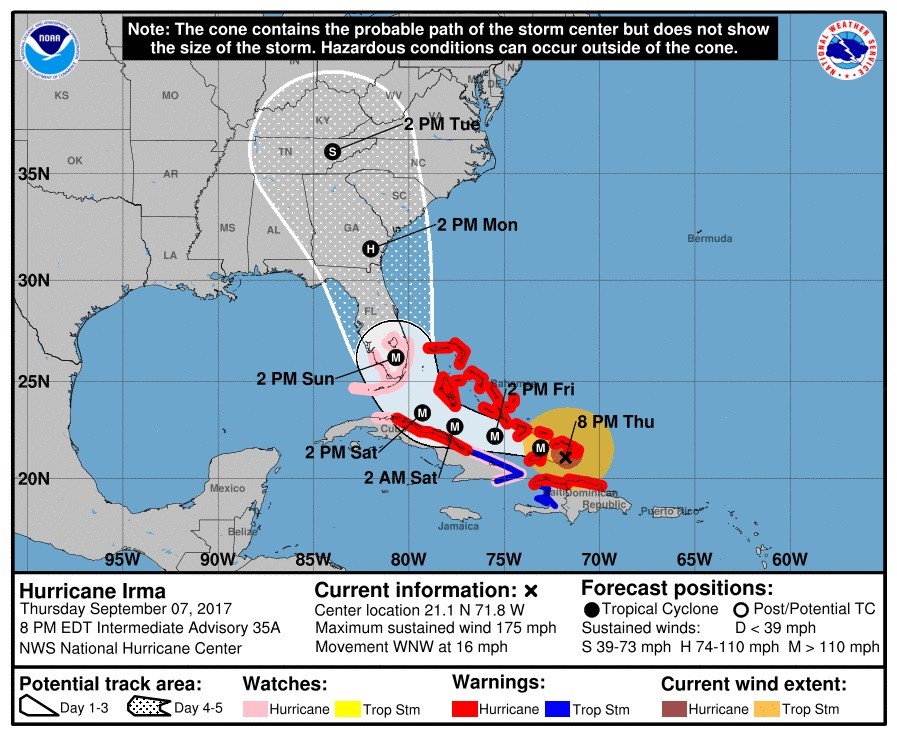
UPDATE 8:30 p.m. ET: The National Hurricane Center’s latest advisory has the storm located at 21.1°N 71.8°W, moving west at 16 mph, 90 miles east of Great Inagua Island.
UPDATE 7:45 p.m. ET: Gov. Nathan Deal (R-GA) orders 540,000 Georgia residents to evacuate ahead of Hurricane Irma.
From the Associated Press:
SAVANNAH, Ga. (AP) — Georgia’s governor on Thursday ordered nearly 540,000 coastal residents to evacuate inland ahead of Hurricane Irma as authorities warned the storm had the potential to strike as a major hurricane, something the Georgia coast hasn’t seen in more than a century.
“If there’s a freight train coming at you, then you get off the tracks,” said Jason Buelterman, mayor of Tybee Island, a beach community of more than 3,000 residents east of Savannah.
UPDATE 6:45 p.m. ET: The Weather Channel’s Jim Cantore: “God help us.”
From the Miami Herald:
Though Cantore hates to be an alarmist, the 53 year old storm tracker believes Irma could be absolutely devastating.
“I have to paint the worst possible scenario,” Cantore admitted. “It would be a disservice to do otherwise. There are dark skies ahead potentially. God help us.”
‘God help us all.’ Weather Channel’s Jim Cantore in Miami for Hurricane Irma https://t.co/FSwzRLBZNd pic.twitter.com/kKbZ8Qmvhh
— Miami Herald (@MiamiHerald) September 7, 2017
UPDATE 5 p.m. ET: The National Hurricane Center’s latest advisory has the storm located at 20.9°N 71.1°W, moving west at 16 mph, 45 miles east of Great Inagua Island.

UPDATE 4:20 p.m. ET: The National Weather Service offers some approximate mileages of Hurricane Irma’s distance from Florida population centers.
As of 3 PM EDT, here as some approximate distances from the eye of Hurricane Irma to a few select central & southern Florida cities. #flwx pic.twitter.com/aYcqwGtv0r
— NWS Tampa Bay (@NWSTampaBay) September 7, 2017
UPDATE 4 p.m. ET: Map shows a high volume of traffic on Florida’s interstate highways in the middle of the evacuation.
This traffic map shows people trying to get out of Florida before Irma hits https://t.co/XOcA4bcTFO pic.twitter.com/aKBN5xuJ0r
— BuzzFeed News (@BuzzFeedNews) September 7, 2017
UPDATE 3:30 p.m. ET: Gov. Nathan Deal (R-GA) has issued mandatory evacuations for coastal areas in Georgia from the Florida state line to the South Carolina state line.
Per @GovernorDeal: all areas E of I-95, all of Chatham Co. & some areas W of I-95 are under a MANDATORY evacuation. See maps for more info pic.twitter.com/8VJQ588T76
— Georgia EM&HS (@GeorgiaEMA) September 7, 2017
UPDATE 3 p.m. ET: ECMWF 12Z suggests a potential westward trek that could impact the entire state from the Florida Keys to Tallahassee.
If Hurricane #Irma takes ECMWF 12z slightly west track, huge wind gusts for Florida from Keys to Miami, Tampa & Orlando, Tallahassee & Jax. pic.twitter.com/SmONxW0I5S
— Ryan Maue | weathermodels.com (@RyanMaue) September 7, 2017
UPDATE 2 p.m. ET: Gov. Rick Scott has activated a total of 4,000 Florida National Guard troops.
4,000 National Guard members now activated for Hurricane Irma https://t.co/L0fg9D7TMa pic.twitter.com/3S0abxSbyi
— Miami Herald (@MiamiHerald) September 7, 2017
UPDATE 1:30 p.m. ET: President Donald Trump offers praise for the state of Florida’s effort in preparing for Hurricane Irma’s landfall.
"Florida is as well prepared as you can be for something like this and we'll see what happens." – Trump in Oval office, per pool. #Irma
— Alex Leary (@learyreports) September 7, 2017
UPDATE 12:30 p.m. ET: Mandatory evacuations have now pushed up the coast to Brevard County, FL, some 200 miles north of Miami-Dade County, FL, where Hurricane Irma is anticipated to make landfall.
9/7/17|12:25AM: Live in the red highlighted area? Then you are in Zone A & under a mandatory evac starting at 3PM Friday, 9/8 pic.twitter.com/jIYVPRWqkW
— Brevard EOC (@BrevardEOC) September 7, 2017
UPDATE 12 p.m. ET: Sen. Bill Nelson (D-FL) lobbied colleagues on the floor of the U.S. Senate to approve $15 billion in funding for FEMA as it is set to expire.
From the Tampa Bay Times:
“I urge the Senate, I implore the Senate, I beg the Senate to pass this package,” Nelson said on the Senate floor. “FEMA is stretched, and, of all things, FEMA runs out of money unless we act by tomorrow.”
Nelson: 'I beg the Senate to pass this package' https://t.co/Sgd8B4yvaI pic.twitter.com/WxReK80sT9
— The Buzz (@PoliticsTBTimes) September 7, 2017
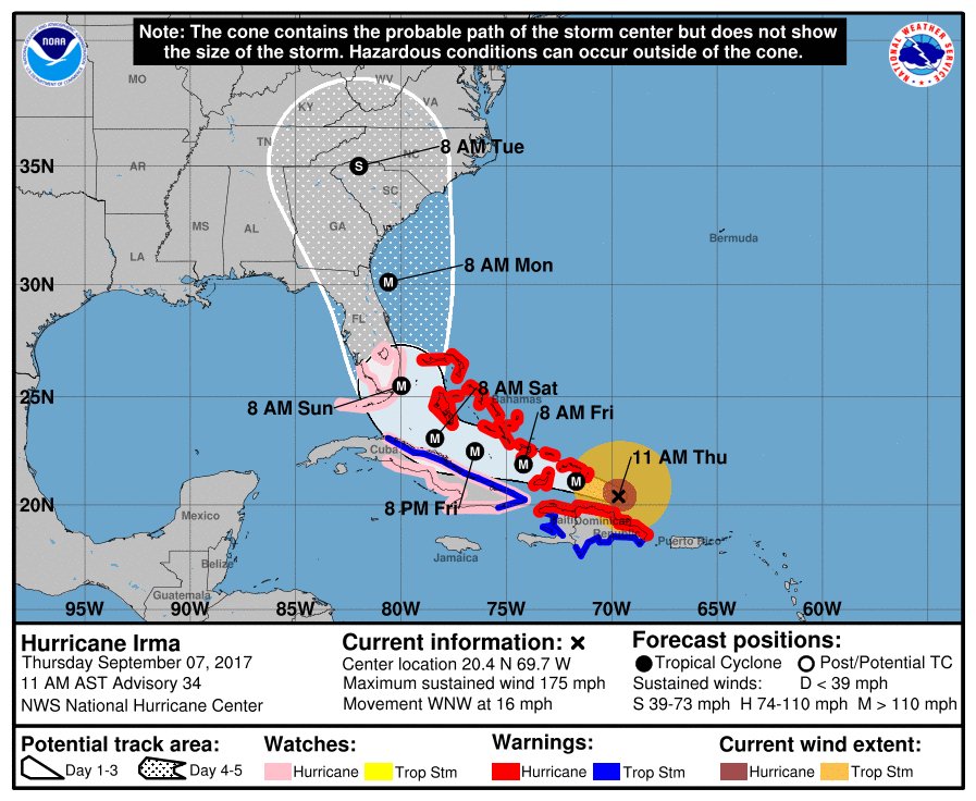
UPDATE 11:15 a.m. ET: The National Hurricane Center’s latest advisory has the storm located at 20.4°N 69.7°W, moving west at 16 mph, 75 miles east of Puerto Plata, Dominican Republic.
UPDATE 11 a.m. ET: A hurricane watch has been issued for the Florida Keys and south Florida north to Jupiter, FL.
As of 11am AST, a Storm Surge Watch has been issued for portions of South Florida and the Florida Keys https://t.co/wCVIdbWe4H pic.twitter.com/19hYm27dDF
— NHC_Surge (@NHC_Surge) September 7, 2017
UPDATE 10:30 a.m. ET: “Once in a generation event” – National Hurricane Center Director Richard Knabb
From my TV interview with NHC Director "if this hits south Florida this is going to be a once in a generation event…the big one for us" pic.twitter.com/NfODX6xVzd
— Craig Setzer (@CraigSetzer) September 7, 2017
UPDATE 10 a.m. ET: Highlights from Rick Scott’s briefing —
.@FLGovScott – "This thing is bigger than our entire state." #hurricaneirma2017
— Gary Fineout (@fineout) September 7, 2017
Gov. Rick Scott authorizes police escorts for gas trucks in Florida
— Charlie Spiering (@charliespiering) September 7, 2017
Florida Gov. Scott says state is coordinating with Google's emergency response team to mark closed roads in real-time on Google Maps pic.twitter.com/T4NwVnyOv8
— CBS News (@CBSNews) September 7, 2017
While in Hialeah @FLGovScott said he knows fuel shortages and traffic jams are "frustrating" for Floridians
— Gary Fineout (@fineout) September 7, 2017
.@FLGovScott on #HurricaneIrma: "It's wider than our entire state and could cause major and life-threatening impacts on both coasts." pic.twitter.com/sbf1zN61Sm
— Fox News (@FoxNews) September 7, 2017
UPDATE 9:25 a.m. ET: Watch briefing live from Hialeah, FL with Gov. Rick Scott.
UPDATE 9:05 a.m. ET: Sen. Bill Nelson (D-FL) says he and Sen. Marco Rubio (R-FL) are lobbying for aid for Irma damage to be included in the Harvey relief package on CNN’s “New Day.”
FL @SenBillNelson explains the resource issues faced by FEMA ahead of Hurricane Irma https://t.co/Ionz6qA0nA
— New Day (@NewDay) September 7, 2017
UPDATE 9 a.m. ET: The National Weather Service says to expect hurricane watches to be issued for the Florida Keys and South Florida today.
Hurricane watches will likely be issued for parts of FL today. TS winds expected to arrive in south FL and the Keys on Saturday #Irma pic.twitter.com/l6WkxYet6P
— National Hurricane Center (@NHC_Atlantic) September 7, 2017
UPDATE 7 a.m. ET: Hurricane Irma continues to dominate front pages of Florida Thursday newspapers, especially along the state’s east coast.
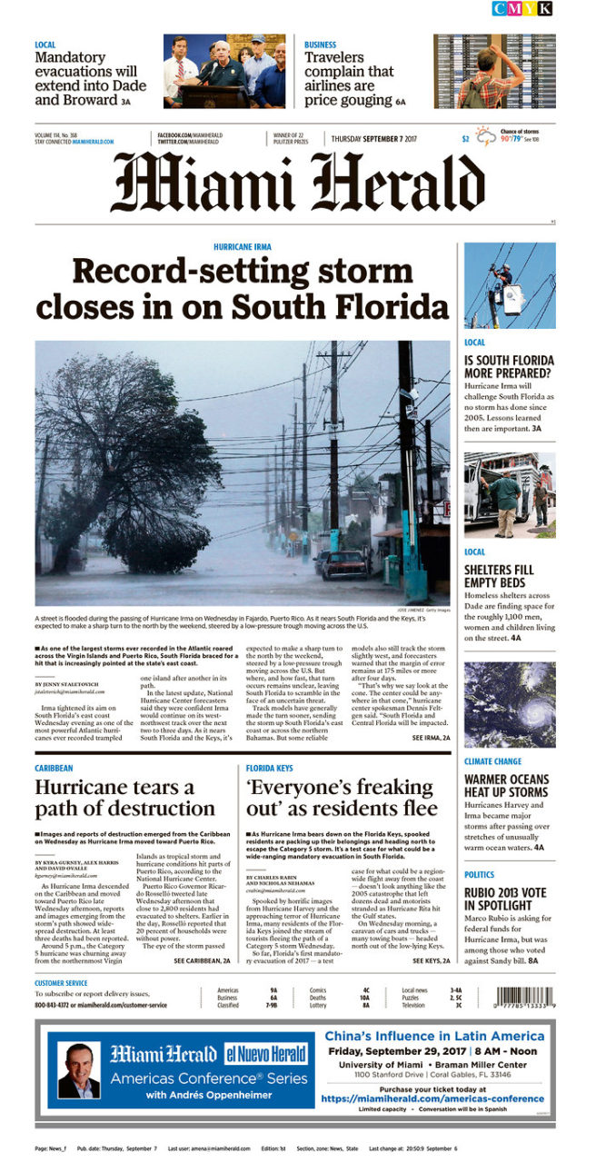
The Miami Herald, 9/7/17
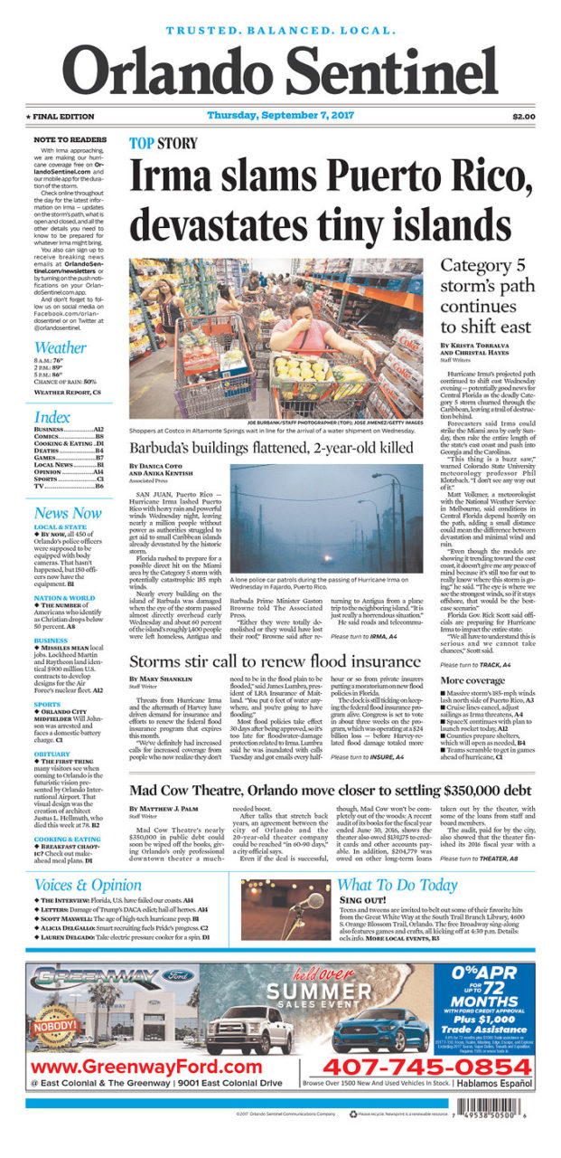
The Orlando Sentinel, 9/7/17

Palm Beach Post, 9/7/17
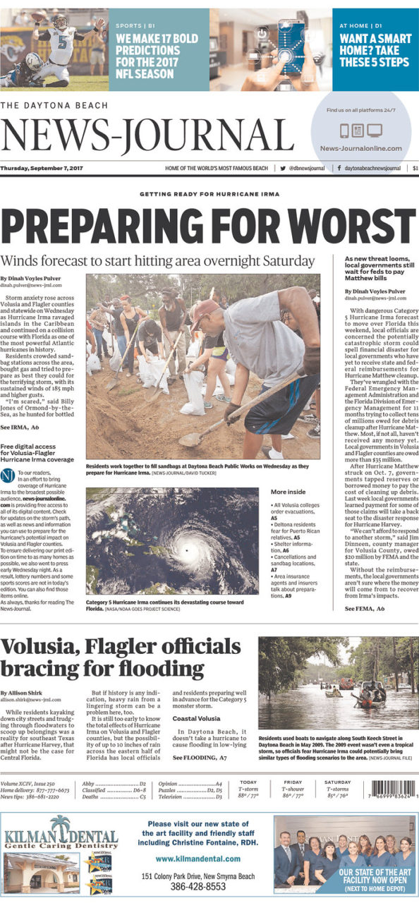
Daytona Beach News-Journal, 9/7/17
Jacksonville’s The Florida Times-Union, 9/7/17
UPDATE 6 a.m. ET: The National Hurricane Center’s latest advisory has the storm located at 20.1°N 69.0°W, moving west at 17 mph, 270 miles east of Grand Turk Island.
UPDATE 1:30 a.m. ET: At least seven have died according to a report from the BBC. Barbuda said to be “barely habitable” and the death toll is “likely to rise”…
From BBC News:
Hurricane Irma has caused widespread destruction across the Caribbean, reducing buildings to rubble and leaving at least seven people dead.
The small island of Barbuda is said to be “barely habitable” while officials warn that the French territory of St Martin is almost destroyed.
With the scale of the damage still emerging the death toll is likely to rise.
UPDATE 12:30 a.m. ET Thursday: According to the Associated Press, Hurricane Irma is responsible for blacking out in much of Puerto Rico.
Hurricane Irma blacks out Puerto Rico, heads for Hispaniola. https://t.co/lr71Tjrmfl
— The Associated Press (@AP) September 7, 2017
NBC News reports an estimated 1 million without power.
Hurricane Irma knocks out power to more than 1 million in Puerto Rico, about a third of the island's population https://t.co/PhDmW2OVxx pic.twitter.com/EMxXIHjhSc
— NBC News (@NBCNews) September 7, 2017
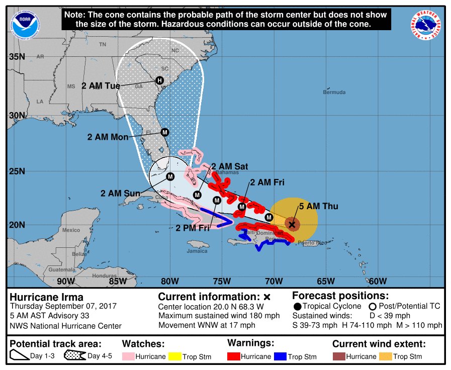
UPDATE 11 p.m. ET: The National Hurricane Center’s latest advisory has the storm located at 19.1°N 66.1°W, moving west at 16 mph, 315 miles east of Grand Turk Island.
UPDATE 10:30 p.m. ET: Traffic is backed up on I-75 near Ocala, FL, which is 300 miles north of Miami (where the storm is expected to make landfall). The Weather Channel has the footage.
UPDATE 9:55 p.m. ET: Per Gov. Rick Scott, the Environmental Protection Agency approved an “emergency fuel waiver” to allow more fuel into the state in preparation for Hurricane Irma.
.@EPA has approved an emergency fuel waiver, allowing more fuel to enter FL quickly for #HurricaneIrma prep: https://t.co/LTkcwBjwUh
— Rick Scott (@FLGovScott) September 7, 2017
UPDATE 9:30 p.m. ET: Miami Beach, FL now under a mandatory evacuation order.
Message from @MayorLevine & @CityManagerMB regarding #HurricaneIrma & the City of Miami Beach: https://t.co/MU48Zs0Xgj pic.twitter.com/jRzDY13Nsu
— City of Miami Beach (@MiamiBeachNews) September 7, 2017
UPDATE 9 p.m. ET: Law enforcement in the Florida Panhandle now warning travelers to be aware of increased traffic due to evacuations.
Evacuations in South Florida have begun. Expect increase
traffic on the Interstate in the Panhandle. Be patient we are all in this
together! pic.twitter.com/onYPZOmSpe— FHP Panhandle (@FHPPanhandle) September 6, 2017
UPDATE 8:30 p.m. ET: Miami-Dade Mayor Carlos Gimenez seeks to dispell the fears of those in the country illegally seeking shelter from Hurricane Irma.
According to the Miami Herald, Gimenez made it known identification would not be checked at shelters.
Miami-Dade tries to avoid Harvey trouble, tells unauthorized immigrants: Don’t fear Irma shelters https://t.co/rsDWvw235d pic.twitter.com/Qdsm5kfOxW
— Patricia Mazzei (@PatriciaMazzei) September 7, 2017
From the Herald’s Patricia Mazzei:
Immigrants in South Florida illegally should not fear deportation if they seek shelter during Hurricane Irma, according to political leaders who urged the undocumented to heed local evacuation orders.
“We don’t ask anybody for their identification,” Miami-Dade Mayor Carlos Gimenez said in a briefing late Wednesday from the county’s emergency operations center in Doral. “Everybody who needs shelter in Miami-Dade County is welcome, and you should do so without any fear of any repercussions.”
UPDATE 7:30 p.m. ET: Amtrak suspends service in Florida.
Amtrak says it will temporarily suspend service in Florida due to Hurricane #Irma. https://t.co/LeEn31zoym pic.twitter.com/UORGfmcNMk
— ABC News (@ABC) September 6, 2017
UPDATE 7:10 p.m. ET: CNBC reports the orange juice market is “going crazy” ahead of Hurricane Irma’s arrival.

From CNBC’s Leslie Shaffer:
Frozen concentrated orange juice futures, the contract made famous in the 1983 Eddie Murphy movie “Trading Places,” spiked higher on Tuesday as Hurricane Irma bore down on Florida.
The Category 5 storm has already set records, with the National Hurricane Center on Tuesday setting its initial intensity at 155 knots, making Irma “the strongest hurricane in the Atlantic basin outside of the Caribbean Sea and the Gulf of Mexico in the NHC records.”
Irma’s course remained uncertain, but many of its potential paths would take it right over Florida.
That sent the ICE frozen concentrated orange juice futures continuous contract spiking up as high as $146.60, from the previous close of $138.60. The contract represents around 15,000 pounds of orange juice solids.
Read more here.
UPDATE 7 p.m. ET: Hurricane Irma longest running Category 5 hurricane since Hurricane Ivan, which made landfall on the Florida Gulf Coast in 2004.
#Irma has now been a Cat. 5 hurricane for over 1.5 days – the most time spent at Cat. 5 for an Atlantic hurricane since Ivan (2004). pic.twitter.com/wqlrqumR7m
— Philip Klotzbach (@philklotzbach) September 6, 2017
UPDATE 6:10 p.m. ET: Former Gov. Jeb Bush (R-FL) applauded Gov. Rick Scott’s handling of Hurricane Irma on Twitter. Nine hurricanes hit Florida during Bush’s tenure as governor, eight of which landed in the Sunshine State in 2004 and 2005.
Proud of @FLGovScott, @FLSERT and local officials for skillfully leading Florida's statewide #Irma prep #GetaPlan https://t.co/pl4dB1fgTz
— Jeb Bush (@JebBush) September 6, 2017
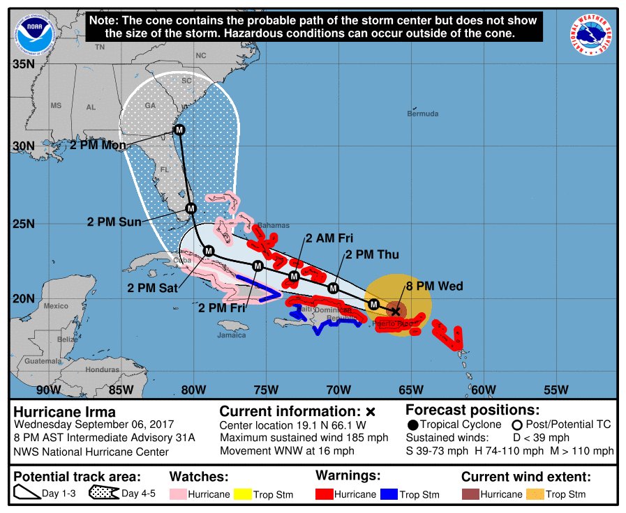
UPDATE 6 p.m. ET: The National Hurricane Center’s latest advisory has the storm located at 18.8°N 65.4°W, moving west at 16 mph, 55 miles east of San Juan, Puerto Rico.
UPDATE 5:25 p.m. ET: Two have died as Hurricane Irma made its way through St. Barts and St. Martin.
At least 2 dead after Hurricane Irma blew through the islands of St. Barts and St. Martin, French official says https://t.co/SsArKtNgSF pic.twitter.com/VN2N2wYRlQ
— CNN Breaking News (@cnnbrk) September 6, 2017
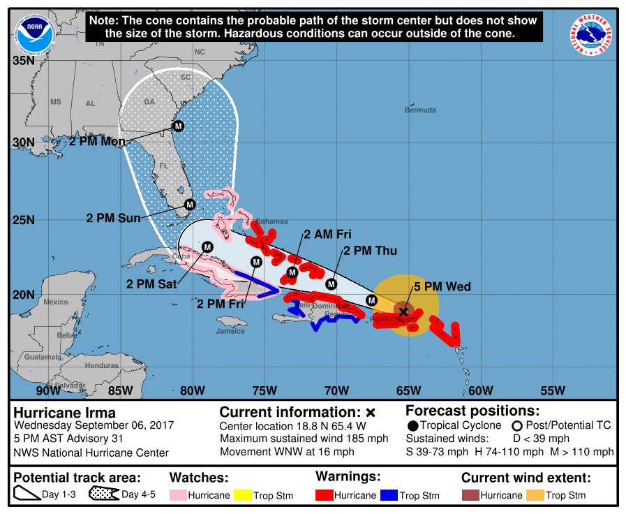
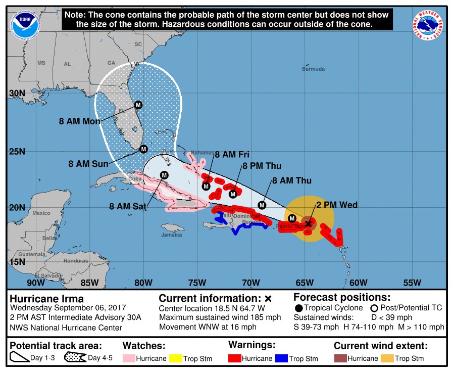
UPDATE 4:30 p.m. ET: The National Hurricane Center’s latest advisory has the storm located at 18.5°N 64.7°W, moving west at 16 mph, 35 miles east of St. Thomas.
UPDATE 4 p.m. ET: Reportedly around 25,000 people have evacuated the Florida Keys.
Around 25k people have evacuated the Florida Keys, according to @FLGovScott. More evacuations expected statewide
— Allison Nielsen (@AllisonNielsen) September 6, 2017
UPDATE 3:15 p.m. ET: Comcast has opened its Wifi Internet hotspots to the public through next week.
Per @FLGovScott: @Comcast opens 137K Florida @XFINITY WiFi hotspots FREE to public thru 9/15. Map: https://t.co/x9hjoYkqli #hurricaneirma pic.twitter.com/smDZk4eQmP
— Florida Cable (FCTA) (@TheFCTA) September 6, 2017
UPDATE 3 p.m. ET: 12Z Euro model show Hurricane Irma making landfall in South Florida and returning to the Atlantic Ocean and making its way north for a second landfall.
12Z Euro slightly west of GFS track. All in the FL Peninsula need to continue to prepare for a major hurricane. GA/SC coasts in play as well pic.twitter.com/Jxjz7D5FkC
— James Spann (@spann) September 6, 2017
UPDATE 2 p.m. ET: South Carolina Gov. Henry McMaster declares a state of emergency as the Palmetto State is now in the forecasted path of Hurricane Irma.
Gov. Henry McMaster Asks South Carolinians to Prepare for Hurricane Irma, Declares State of Emergency pic.twitter.com/IxpyGY4EZX
— SC Governor Press (@scgovernorpress) September 6, 2017
UPDATE 1:25 p.m. ET: A story from the Miami Herald warns some Puerto Ricans could be without power for four to six months after Hurricane Irma passes.
In Puerto Rico, the electric company warned the island could be without power for four to six months while the government prepared to open 456 shelters capable of housing more than 62,000 people.
(h/t The Hill)
UPDATE 12:40 p.m. ET: Hurricane Irma’s outer bands are beginning to arrive in Puerto Rico.
1230p: Eye of #Irma passing over Virgin Gorda in BVI. Outer bands lashing NE Puerto Rico. pic.twitter.com/rBws3YaLyV
— Capital Weather Gang (@capitalweather) September 6, 2017
UPDATE 12:20 p.m. ET: Watch briefing live from Doral, FL featuring Gov. Rick Scott.
UPDATE 12 p.m. ET: The National Hurricane Center’s 11 a.m. advisory has the storm located at 18.2°N 64°W, moving west at 16 mph, 65 miles east of St. Thomas.

UPDATE 11:30 a.m. ET: Polk County, FL Sheriff Grady Judd has a stern warning for those with warrants that show up at shelters seeking refuge from Hurricane Irma.
If you go to a shelter for #Irma and you have a warrant, we'll gladly escort you to the safe and secure shelter called the Polk County Jail https://t.co/Qj5GX9XQBi
— Polk County Sheriff (@PolkCoSheriff) September 6, 2017
UPDATE 10:30 a.m. ET: According to the Tampa Bay Times, traffic is starting to clog on Florida’s roadways as evacuations are underway.
Traffic begins to clog northbound highways across Florida https://t.co/3VOuB3xvv8 via @TB_Times
— Justine Griffin (@SunBizGriffin) September 6, 2017
UPDATE 10 a.m. ET: Scott has deployed additional Florida National Guard Troops, per South Florida Sun Sentinel’s Dan Sweeney.
100 deployed yesterday means 1000 in the field now. Mostly doing logistical and prep work ahead of storm. https://t.co/BWHOi58HJQ
— Dan Sweeney (@Daniel_Sweeney) September 6, 2017
UPDATE: 9:35 a.m. ET: Watch briefing live from Marathon, FL featuring Gov. Rick Scott.
UPDATE 9:30 a.m. ET: Barclays: Hurricane Irma’s damage could be most ever, topping 2005’s Hurricane Katrina.
CNBC has a report on Barclays warning Hurricane Irma could top Katrina in its damage toll.
“Given the potential magnitude of this storm as well as the potential to impact a highly populated area, we think Irma’s insured damage in Florida could be the largest ever in the US perhaps equivalent to Hurricane Katrina,” wrote Barclays’ Jay Gelb on Tuesday.
UPDATE 8 a.m. ET: Views from NOAA’s Hurricane Hunters’ aircraft give a rare peek of images high above a Category 5 hurricane.
Video from yesterday's flight in CAT 5 #Irma on #NOAA42. https://t.co/iofV4p56DE has the latest advisories. Credit Rob Mitchell/NOAA pic.twitter.com/IygcNgIbJN
— NOAA Aircraft Operations Center (@NOAA_HurrHunter) September 6, 2017
UPDATE 7:30 a.m. ET: Most computer models now have the storm turning north just as it passes over the Bahamas.
UPDATE 7 a.m. ET: Hurricane Irma dominates the front pages of Florida Wednesday newspapers from Miami to Pensacola.

Miami Herald, 9/6/2017
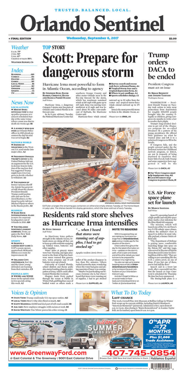
Orlando Sentinel, 9/6/17
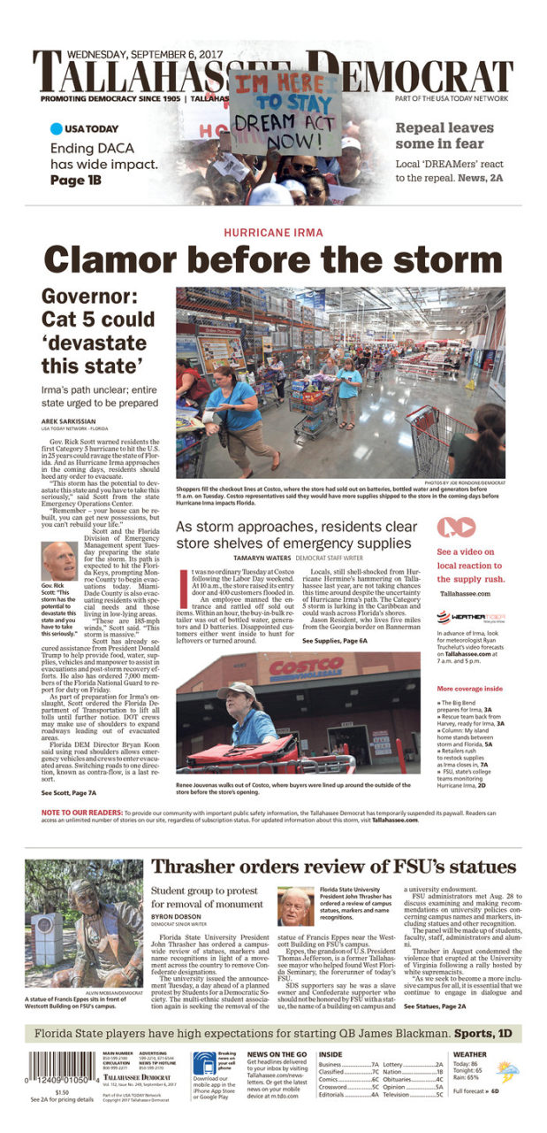
Tallahassee Democrat, 9/6/17

Pensacola News Journal, 9/6/17
UPDATE 12 a.m. ET Wednesday: According to a report, the Key West International Airport will be forced to close due to the TSA’s decision not to staff security checkpoints. Key West Mayor Craig Cates called the decision “very disappointing.”
More here.
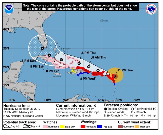
UPDATE 11:30 p.m. ET: The National Hurricane Center’s 11 p.m. advisory has the storm located at 17.4°N 61.1°W, moving west at 15 mph, 50 miles east of Antigua.
UPDATE 10:30 p.m. ET: In a statement issued late Tuesday, Gov. Rick Scott ordered state offices in all of Florida’s 67 counties closed.
Statement as follows:
TALLAHASSEE, Fla. – Today, Governor Rick Scott directed state offices to be closed in all 67 Florida counties this Friday in preparation for Hurricane Irma. Prior to Friday’s statewide closures, state office closures will follow the direction of county officials and will be announced as they are determined. The Governor also issued a call to state employees across Florida encouraging them to volunteer in support of the state’s emergency shelter mobilization efforts.
Governor Scott said, “Our state workforce is filled with dedicated individuals who go above and beyond every day in service to the families who call Florida home. Ensuring the safety of these hardworking individuals and their families is a top priority, and I am directing all state offices to be closed this Friday so our state employees can fully focus on preparing for this storm and keeping their families safe. I am also asking these talented individuals to consider donating their time and effort to become a certified American Red Cross Disaster Services volunteer to help Floridians in need.
“I have directed all state executive agencies to authorize the deployment of any American Red Cross certified employees willing to volunteer to help in or operate shelters in response to this unprecedented storm. Agency leaders have also been authorized to grant employee volunteers training time in order to become certified if they are not already. We must do all we can to prepare our families and communities for any potential impact from this major weather event, and I appreciate the many volunteers who are gearing up to help our state during this critical time.”
In partnership with the American Red Cross, salaried, non-essential state employees can receive expedited volunteer certifications for disaster services so that they may assist in or operate shelters in response to Hurricane Irma impacts and preparation. Florida law allows Governor Scott to grant full-time, salaried state employees up to 15 days of administrative leave for emergency volunteer efforts through the American Red Cross. All Floridians can register for American Red Cross certifications at VolunteerFlorida.org.
UPDATE 9 p.m. ET: Miami Beach, FL Mayor Philip Levine is urging his residents to evacuate. According to a Miami Herald report, Levine did so at a press conference earlier today.
“I’m personally recommending to our residents that you consider leaving the city of Miami Beach in advance of the evacuation order that we anticipate will be coming from the county mayor,” Levine said.
As Miami Beach braces for Irma, mayor urges residents to evacuatehttps://t.co/OxBWjKIvUz pic.twitter.com/JXnthwKDh9
— Miami Herald (@MiamiHerald) September 6, 2017
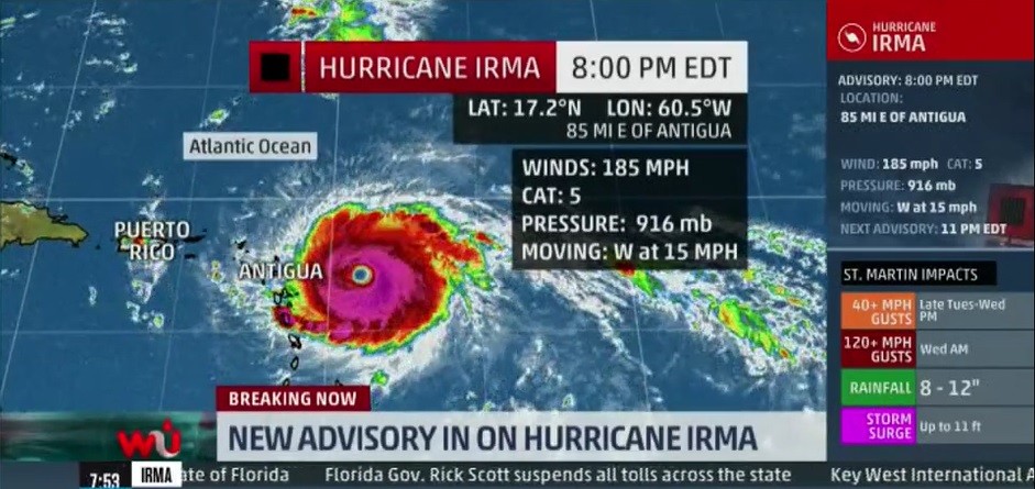
UPDATE 8 p.m. ET: The latest advisory from the National Hurricane Center on Hurricane Irma has the storm at 17.2°N 60.5°W, moving west at 15 mph, 85 miles east of Antigua.
UPDATE 7 p.m. ET: Per the White House’s Tom Bossert, President Donald Trump has declare emergencies in the U.S. Virgin Islands, Puerto Rico and Florida.
@POTUS @realDonaldTrump declares emergencies in #USVirginIslands, #PuertoRico & #Florida. @FEMA_Brock #HurricaneIrma Thoughts and prayers.
— Thomas P. Bossert (@TomBossert45) September 5, 2017
UPDATE 6:45 p.m. ET: NASA offers a breath-taking look afternoon glimpse of Irma.
Late afternoon sun casting a shadow on Hurricane #Irma's eye. #GOES16 pic.twitter.com/CQaSgHzVN6
— NASA SPoRT (@NASA_SPoRT) September 5, 2017
UPDATE 5:45 p.m. ET: Kristen Clark of The Miami Herald’s Tallahassee bureau reports Gov. Rick Scott has suspended toll collection on Florida’s roadways effective 5 p.m. on Tuesday.
ICYMI: No more roadway tolls "until further notice" as #Florida prepares for Hurricane #Irma: https://t.co/QLhiseBtW5 @MiamiHerald pic.twitter.com/D6HidcqSLJ
— Kristen M. Clark (@ByKristenMClark) September 5, 2017
UPDATE 5:30 p.m. ET: The latest computer model tracking still shows most of the models predicting Irma’s northward turn just south of Miami. However, some are starting to show Irma continuing a more westwardly track and turning into the Gulf of Mexico.
UPDATE 5:20 p.m. ET: Scott says Hurricane Irma’s landfall will be unlike anything the state has experienced since Hurricane Andrew’s landfall in 1992 near Homestead, FL.
From FloridaPolitics.com:
“One of the things that I talked with the acting director of FEMA today (Robert Fenton) is ‘don’t wait,’” he told reporters. “But we haven’t had a landfall like this since Andrew,” he said referring to the August 1992 storm, the last Category 5 rainmaker to hit the U.S. mainland.
UPDATE 5 p.m. ET: The latest advisory from the National Hurricane Center has Hurricane Irma as a Category 5 storm and will weaken to a Category 4 storm as it makes it way through the Carribbean and into the Florida Keys.
#firstalertwx #Irma UPDATED 5pm advisory Tue., 09/05 @WOKVNews pic.twitter.com/N6JrEotSoG
— Mike Buresh (@MikeFirstAlert) September 5, 2017
UPDATE 4:30 p.m. ET: WeatherBELL Analytics meteorologist and Cato Institute adjunct scholar Ryan Maue suggests Hurricane Irma winds could top a record-setting 200 mph.
Eye continues to warm now +20°C … if convection flares or clouds cool (more pink) then Hurricane #Irma should reach 200 mph. pic.twitter.com/yzJ5EFFTPt
— Ryan Maue | weathermodels.com (@RyanMaue) September 5, 2017
UPDATE 2:30 p.m. ET: The Miami Herald has made available a list of closures and event cancelations in Miami-Dade and Monroe Counties.
UPDATE 1 p.m. ET: The sheriff’s department for Monroe County, FL, which includes the Florida Keys and the extreme mostly uninhabited southwestern corner of the Florida peninsula, has issued a mandatory evacuation order.
Monroe County will issue mandatory evacuations of tourists & residents beginning tomorrow. For details, go to https://t.co/RmY672b0bj
— Florida Keys Sheriff (@mcsonews) September 5, 2017
UPDATE 11:50 a.m. ET: Scott has activated the Florida National Guard.
I have now activated 100 FL National Guard members to assist with #HurricaneIrma preparedness. https://t.co/tZyHtGXVTi (1/2)
— Rick Scott (@FLGovScott) September 5, 2017
I’ve also directed all 7,000 guard members to report for duty this Friday and am ready to activate all needed for preparedness actions (2/2)
— Rick Scott (@FLGovScott) September 5, 2017
UPDATE 11:30 a.m. ET: Gov. Rick Scott (R-FL) has called on President Donald Trump to declare a “pre-landfall emergency” for Florida as Hurricane Irma nears.
Today I asked @POTUS to declare a pre-landfall emergency for the State of Florida in preparation for #HurricaneIrma https://t.co/3CAzMZAr1j
— Rick Scott (@FLGovScott) September 5, 2017
UPDATE 11:15 a.m. ET: Tropical Storm Jose has formed in the path of Hurricane Irma.
More bad news: We now have Tropical Storm #Jose in the Atlantic behind #Irma. Expected to become a hurricane in 36-48 hours. pic.twitter.com/pGP3gHLEcI
— Steven Shepard (@POLITICO_Steve) September 5, 2017
UPDATE 11 a.m. ET: Miami’s WVNN has the latest computer models, which show Hurricane Irma still a threat to the entire state of Florida.
Latest models as of 11 am #Irma @wsvn pic.twitter.com/mylMEfmkYJ
— 7 Weather (@7Weather) September 5, 2017
UPDATE 10 a.m. ET: The Weather Channel’s “Threat Index” coverage area now includes from Tampa eastward to Daytona Beach and all points south in the state of Florida.
UPDATE 9 a.m. ET: Miami’s NBC 6 reports emergency operation centers in Miami-Dade and Monroe Counties will be activated. Also, the report notes the rush hurricane preparedness supplies and predicts gas prices will continue rise in South Florida.
UPDATE 8:30 a.m. ET: National Weather Service in Key West, FL reports tropical storm force winds from Irma could reach the Florida Keys by Friday.
Key messages for #Irma from @NHC_Atlantic. Earliest reasonable tropical storm force winds for the #FLKeys – Friday evening. #FLwx #KeyWest pic.twitter.com/j0qZW38JLT
— NWS Key West (@NWSKeyWest) September 5, 2017
UPDATE 8 a.m. ET:: Hurricane Irma now a Category 5 storm.
NHC: “Hurricane #Irma has intensified into an extremely dangerous Category 5 hurricane … with maximum winds of 175 mph” pic.twitter.com/qdCFrRBVhb
— Alex Lamers (@AlexJLamers) September 5, 2017
UPDATE 12:45 a.m. ET Tuesday: Latest 00Z GFS model shows Hurricane Irma impacting the entire peninsula of Florida.
New 00Z GFS paints a bleak picture for the FL Peninsula Saturday night/Sunday. People in South Florida need to take this threat seriously. pic.twitter.com/EFwwEzu7Nm
— James Spann (@spann) September 5, 2017
UPDATE 11 p.m. ET: Hurricane warnings have issued by the National Weather Service in Miami for Puerto Rico and the U.S. Virgin Islands.
Hurricane warnings issued for Puerto Rico and the Virgin Islands… pic.twitter.com/bIMv5QhxnU
— James Spann (@spann) September 5, 2017
UPDATE 10 p.m. ET: Both the European Medium Range Forecast and NOAA’s Global Forecast System models have Hurricane Irma near the population centers of South Florida at 8 a.m. ET Sunday morning.
As of right now, the global models are in good agreement on the placement of #Irma over the weekend. Stay tuned. pic.twitter.com/Gg1EyDBLDq
— Alan Auglis (@alanauglis) September 5, 2017
UPDATE 9:30 p.m. ET: Florida Attorney General Pam Bondi has activated her office’s price gouging hotline.
Floridians need to prepare now and they should not be inhibited by unlawful price increases: https://t.co/XricmPVZ0X #Sayfie pic.twitter.com/onoV3JTTbj
— Fla. AG Pam Bondi (@AGPamBondi) September 5, 2017
UPDATE 8:30 p.m. ET: The Tampa Bay Times reports a hurricane hunter airplane has detected 140 mph sustained winds within Hurricane Irma.
Hurricane hunter plane finds Hurricane Irma has sustained winds of 140 mph now https://t.co/pVVxAOZWDq pic.twitter.com/MBAo2b6CxJ
— Tampa Bay Times (@TB_Times) September 5, 2017
UPDATE 7:30 p.m. ET: Tampa-Sarasota CBS affiliate WTSP reports the NFL is considering moving the Miami Dolphins and Tampa Bay Buccaneer’s season opening game scheduled for Sunday at 1 p.m. ET at the Hard Rock Stadium in Miami Gardens.
Hurricane Irma may force NFL to move or reschedule Buccaneers vs. Dolphins https://t.co/ihgDESTs28 pic.twitter.com/X5BWXg9xJq
— 10News WTSP (@10NewsWTSP) September 4, 2017
UPDATE 7:15 p.m. ET: The Weather Channel’s “Weather Underground” warns everything from Texas to Maine is potentially threatened by Hurricane Irma. However, the specificity is dependent upon Irma’s path through the Carribean, which is influenced by other weather patterns in and around the United States’ mainland.
UPDATE 5:21 p.m. ET: Shortly after the National Hurricane Center classifying Hurricane Irma as a Category 4 hurricane, Scott declared a state of emergency in Florida.
#BREAKING @FLGovScott declares state of emergency for all of Florida ahead of #Irma pic.twitter.com/4e5AJ5PfM7
— WPLG Local 10 News (@WPLGLocal10) September 4, 2017
Scott tweeted that all 67 counties in Florida are under the state of emergency.
I have declared a state of emergency for every FL county to help state, federal and local governments work together as we prepare for #Irma.
— Rick Scott (@FLGovScott) September 4, 2017
UPDATE 5 p.m. ET: As of 5 p.m. ET, Irma is a Category 4 hurricane roughly 600 miles east of the Leeward Islands (16.7 N 54.4 W.)
#Irma has become a category 4 hurricane. Preparations within the warning area should be rushed to completion. https://t.co/tW4KeGdBFb pic.twitter.com/40N9AjuXCo
— National Hurricane Center (@NHC_Atlantic) September 4, 2017
Scott posted a series of tweets over Sunday and Monday regarding preparation for Irma should it continue its northwesterly track and into Florida as some computer models have shown.
Pay attention to #Irma & have your plans in place. Official NHC forecast at https://t.co/rj0mCuAf88 & Get A Plan at https://t.co/tPNEQWSavp pic.twitter.com/KUWYo6MytY
— Florida SERT (@FLSERT) September 4, 2017
Families should take time today to make sure you have a disaster plan and fully-stocked Disaster Supply Kit. https://t.co/RPmB3zapP3
— Rick Scott (@FLGovScott) September 4, 2017
I am continuing to coordinate with emergency management officials as we monitor Hurricane Irma.
— Rick Scott (@FLGovScott) September 4, 2017
FL knows how important it is to be prepared. Encourage your loved ones to have a plan ahead of any potential storm. https://t.co/KL3IqYzpTd
— Rick Scott (@FLGovScott) September 3, 2017
As we continue to monitor Hurricane Irma, families should make sure their Disaster Supply Kits are ready today. https://t.co/ymXjrTHewW
— Rick Scott (@FLGovScott) September 3, 2017
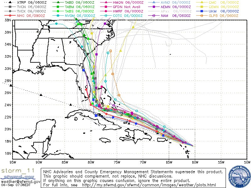
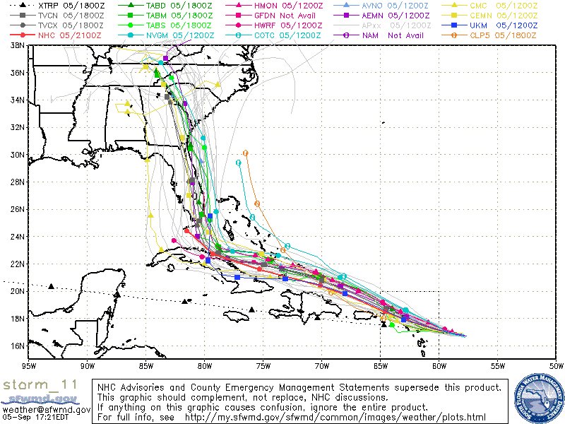
The storm is beyond the five-day window that NOAA and NWS officials could predict landfall in the Sunshine State. However, many of the computer models have Irma hitting the Florida peninsula.
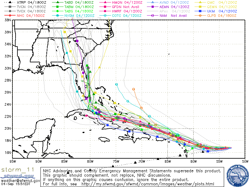
Hurricane Irma Computer Models, courtesy of South Florida Water Management District
Follow Jeff Poor on Twitter @jeff_poor
COMMENTS
Please let us know if you're having issues with commenting.