
**LIVE UPDATES**
Record flooding of the Mississippi River and its tributaries has already left at least 20 dead in Missouri and Illinois and forced thousands in the Midwest to evacuate their homes. Local, state, and federal agencies as well as the Red Cross are assisting in the rescue and evacuation efforts in what is turning out to be the worst flood in the region since 1993. The U.S. Army Corps of Engineers is monitoring 19 area levees at risk as the flood waters continue to rise. Follow us for live updates below.
8:43 pm ET: The latest from the Associated Press:
Officials are preparing for the possible closure of a major interstate highway south of St. Louis amid historic flooding.
The Missouri Department of Transportation said Wednesday night that I-55 at the Meramec River near Arnold could close overnight or Thursday. An aggressive sandbagging operation was underway to keep the lanes open. Other connections between St. Louis and Jefferson counties already are closed, including I-44 over the river.
6:55 pm CST: The latest from the Associated Press:
The U.S. Army Corps of Engineers says that flood water from the Mississippi River and its tributaries has spilled over nine federal levees in the St. Louis area.
Forecast maps released Wednesday afternoon show reduced flooding risks at another 10 area levees deemed vulnerable one day previously. Corps spokesman Rene Poche says that most of the overtopped levees protect primarily agricultural areas.
Eleven levees still face “possible significant distress,” including one in Valley Park, Missouri. The St. Louis suburb has ordered mandatory evacuations of hundreds of homes and dozens of businesses near the rising Meramec River.
Poche said that “no one is in imminent danger” if the Valley Park levee spills over. He and other Corps officials also emphasized that the affected levees were not breached.
7:25 pm ET: The Associated Press reports on the deaths of five international soldiers who drowned in Missouri on Saturday due to the flooding:
FORT LEONARD WOOD, Mo. (AP) — Five international soldiers who were on holiday leave during a temporary assignment at Fort Leonard Wood drowned when their car went off a dark, rural highway in southwest Missouri.
The soldiers were returning to the fort from Osage Beach Saturday night when their car was swept off Highway U near Crocker, about 15 miles northwest of Fort Leonard Wood, Pulaski County Sheriff Ron Long said.
All five soldiers were attending officer education at the Maneuver Support Center of Excellence, a program that brings troops from other countries to the installation to study engineering, military policing and chemical defense.
The victims were identified Wednesday as Maj. Mohammad Hassan Ibrahim, 32, Egypt; Maj. Akram Abu Al-rub, 38, Jordan; Capt. Ahmed Moussouni, 32, Algeria; Capt. Ahmed Abdelghani, 29, Egypt; and Capt. Hasman Hussin, 33, Malaysia. Fort officials said the bodies are being returned to the men’s home countries for burial.
The bodies of four of the trainees were recovered Sunday and the fifth was found Tuesday.
“Some were recovered in the car and outside it,” Long told The St. Louis Post-Dispatch ( https://bit.ly/1NWjtbt ). “The last one was way downstream.”
The men were driving back to the fort after a shopping trip, he said. A witness reported seeing the car go off the road about 8:30 p.m. Saturday and quickly lost sight of the car floating away.
“It’s just a very dark and rural highway, and I am sure they had no idea of what was ahead of them until they got into the water,” Long said. “Most of the time, these roads are traveled by people who know what lies ahead. They don’t venture off into the water.”
6:00 pm CST: The latest from the Associated Press:
The Kentucky Transportation Cabinet plans to close U.S. 51 at two locations in western Kentucky in response to flooding forecasts.
The cabinet said waters are rising more quickly, and both the U.S. 51 Ohio River “Cairo” Bridge and U.S. 51 south of Wickliffe near the Ballard-Carlisle county line will close at midnight Wednesday.
The cabinet said in a news release that levels at which the road is required to close are expected to be exceeded during the overnight hours.
Spokesman Keith Todd of District 1 said closing at midnight will allow Highway Department workers to barricade the roadway. Closure at the two sites is expected to last at least a week.
Todd said in the release that millings will be placed around the barricades to keep them from being moved.
7:37 pm ET: The Chicago Tribune reports:
No substantial flooding was reported in the Chicago area, but overflowing waters have plagued areas along the Kankakee and Iroquois rivers south of the city, including in the community of Morris, about 65 southwest of Chicago, and in southern Lake and Porter counties in Indiana.
Points along those waterways had crested by Wednesday without reports of major damage, and the waters were expected to subside in coming days, said David Beachler, a meteorologist for the National Weather Service stationed in Romeoville.
Wednesday evening, Illinois Gov. Bruce Rauner added Alexander, Christian, Clinton, Douglas and Morgan counties to the state disaster declaration for widespread flooding. This brings the statewide total of declared counties to 12, according to a press release issued by his office.
On Tuesday, Rauner issued declarations for Calhoun, Jackson, Jersey, Madison, Monroe, Randolph and St. Clair counties.
6:52 pm ET: The latest from the Associated Press:
ST. LOUIS (AP) — As swollen rivers and streams pushed to heights not seen in nearly a quarter-century, officials in Missouri and Illinois helped residents get to higher ground Wednesday amid fears that already dire conditions could worsen as floodwaters began spilling over the federal levees protecting some communities and farmland.
In Eureka southwest of St. Louis, firefighters and their boats have been in high demand since Tuesday, accounting for roughly four dozen rescues of people in their homes, businesses or vehicles. Television news footage showed at least one home there drifting in the swollen river Wednesday, when firefighters rescued by boat a man and a dog as floodwaters lapped at the eaves of the house roof on which they’d been trapped for a night.
“Our crews are getting dispatched to another rescue now,” Scott Barthelmass, a Eureka Fire Protection District spokesman, said mid-afternoon Wednesday as the swollen Meramec River there was cresting. “I think you’re seeing people who are desperate or impatient, putting themselves in predicaments.”
The U.S. Army Corps of Engineers announced Wednesday that nine levees had been topped by water, although some of those earthen barriers were meant to protect farmland rather than populated areas so it wasn’t immediately clear how many homes were in jeopardy. Nearly a dozen other levees were considered at risk for “possible significant distress” but were holding as of Wednesday evening, the Army Corps said.
But people were moving out just in case, including the St. Louis suburb of Valley Park, where Mayor Michael Pennise ordered mandatory evacuations for 350 to 400 homes and dozens of businesses in the section of town near the fast-rising Meramec River.
At least 20 deaths over several days in Missouri and Illinois were blamed on flooding, mostly involving vehicles that drove onto swamped roadways, and at least two people were still missing Wednesday.
And search teams went out for a third day in hopes of finding a country music singer from Arkansas who disappeared while duck hunting in a flooded area in northern Oklahoma. The floodwaters there also destroyed a leftover film set used in the 2003 remake of “Where the Red Fern Grows.”
A 24-mile stretch of Interstate 44 was closed at Valley Park southwest of St. Louis due to Meramec River flooding. The closure forced traffic onto other nearby roads, creating gridlock in the St. Louis region. Officials said the highway will likely remain closed through at least Friday. Missouri Gov. Jay Nixon has activated the National Guard to assist with security in evacuated areas and to help keep road closure sites clear.
Valley Park City Attorney Tim Engelmeyer called the governor’s office to send troops to help in the evacuated area of the about 7,000-person town. He was also watching computer projections of the crest — expected to be about 3 feet higher than the record of 40 feet on Thursday — knowing that an unexpected upgrade could be enough to send water over the levee.
“We’re so close,” he said. “We’re talking about a potential 6-inch difference.”
Pennise said the corps is confident the levee, built in 2007, is safe, but ordered evacuations as a precaution.
“You don’t want to think negative, but we’d rather save a life than a couch,” Pennise said.
Becky Bode, a 54-year-old postal carrier whose route includes lower Valley Park, said the area used to flood so frequently that residents mostly had flood insurance. With the levee, many don’t.
Still, she’s not worried about the residents.
“They’ve been through it before,” Bode said. “If it floods, they’ll pop back up and get going again.”
In the southwestern Missouri tourist mecca of Branson, residents of about 150 duplexes and homes had to evacuate Wednesday due to flooding from a manmade lake. But the shopping district along the lake was still open, Fire Chief Ted Martin said, adding, “it has been packed with people, and I don’t know where all of them have come from.”
Sixty miles to the north in Pleasant Hope, the emergency management director said crews are looking for a missing motorist.
“Nobody that is living has ever seen anything like this,” Rick Davis said.
Three-day rainfall totals of 9 to 11 inches were records in some parts of an area that stretched from southwest to east-central Missouri, said Mark Fuchs, a hydrologist for the National Weather Service in St. Louis. Rainfall totals of that magnitude occur only every 100 to 300 years, according to rainfall frequency data from the National Oceanic and Atmospheric Administration.
The Mississippi River is expected to reach nearly 13 feet above flood stage on Thursday at St. Louis, which would be the second-worst flood on record, behind only the devastating 1993 flood.
In the historic riverfront city of Alton, Illinois, some downtown business owners continued to scramble Wednesday to keep out rising water from the Mississippi River.
Most of the damage in the city 15 miles north of St. Louis, a stop on the 19th Century Underground Railroad, was confined to high water in some basements. Firefighters and emergency road crews worked to pump out water from flooded storm drains behind a seven-foot-high, 1000-foot-long temporary retaining wall reinforced by gravel and sandbags.
The Argosy Alton casino, which shut down on Monday, remained closed. So did the southbound lane of the main highway connecting the city to Missouri.
Alton Mayor Brant Walker said he’s “very optimistic that what we’ve built here will hold” as the Mississippi River is expected to crest at 38 feet on Thursday, 17 feet above flood stage.
That confidence was of little consolation to Tim Meeks, who was loading vats of gourmet olive oil from his downtown market onto a trailer headed to higher ground as other employees worked to drain a basement filled with 7 feet of standing water.
“We don’t keep anything down there anymore,” he said. “All of our product has to go.”
___
Scher Zagier reported from Alton, Illinois. Associated Press writers Jim Suhr and Heather Hollingsworth in Kansas City, Missouri, contributed to this report.
The U.S. Army Corps of Engineers says that flood water from the Mississippi River and its tributaries has spilled over nine federal levees in the St. Louis area.
Forecast maps released Wednesday afternoon show reduced flooding risks at another 10 area levees deemed vulnerable one day previously.
Eleven levees still face “possible significant distress,” including one in Valley Park, Missouri. The St. Louis suburb has ordered mandatory evacuations of hundreds of homes and dozens of businesses near the rising Meramec River.
5:30 pm CST: The latest from the Associated Press:
Illinois Gov. Bruce Rauner is returning early from a vacation outside the U.S. to visit areas damaged by floods and thank volunteers.
Rauner’s office said Wednesday the governor will be in Springfield on Thursday night. He will spend the next several days in central and southern Illinois, where severe weather has led to flooding and seven deaths.
Rauner left the country sometime during the weekend of Dec. 19-20 to spend the holidays with his family. His office wouldn’t say where he was or the reason they were keeping his whereabouts secret.
He had been scheduled to return to Illinois on Sunday.
Rauner spokesman Lance Trover says the governor plans to tour areas dealing with severe weather and ensure “that communities have everything they need.”
Rauner on Tuesday issued a disaster proclamation for seven counties, where about 7 inches of rain fell between Dec. 23 and 28.
6:29 pm ET: Danielle Scrubbs with Fox2 in St. Louis has video of the rescue of a man in Eureka, Missouri, who was stranded on top of his pickup truck in the Meramec River.
Scrubbs also tweeted some harrowing images earlier today showing the extent of the damage and various rescue efforts:
Man trapped on hood of pick up truck in #Eureka @SkyFOXSTL @FOX2now pic.twitter.com/R2McC1Ropd
— Danielle Scruggs (@DanielleScruggs) December 30, 2015
Fire crews rescue man trapped on hood of pick up truck in #MeramecRiver @SkyFOXSTL @FOX2now pic.twitter.com/6gvj7IaVq4
— Danielle Scruggs (@DanielleScruggs) December 30, 2015
Store owner possibly trying to save inventory #MeramecRiver @SkyFOXSTL @FOX2now pic.twitter.com/Iz31aEOS4B
— Danielle Scruggs (@DanielleScruggs) December 30, 2015
Man successfully rescued, truck saved in #MeramecRiver in #Eureka Yes those are his legs! @SkyFOXSTL @FOX2now pic.twitter.com/DaTQFn2X9j
— Danielle Scruggs (@DanielleScruggs) December 30, 2015
#EurekaHighSchool under water @SkyFOXSTL @FOX2now pic.twitter.com/YMvBmsMT3W
— Danielle Scruggs (@DanielleScruggs) December 30, 2015
Emergency crews to the rescue along #MeramecRiver @SkyFOXSTL @FOX2now pic.twitter.com/sT4VBcspmz
— Danielle Scruggs (@DanielleScruggs) December 30, 2015
Men come to rescue woman stranded in car along #MeramecRiver Rescue team returns to help @SkyFOXSTL @FOX2now pic.twitter.com/DKjpMsQ5dy
— Danielle Scruggs (@DanielleScruggs) December 30, 2015
Flooding Wednesday morning across St. Louis area @SkyFOXSTL @FOX2now pic.twitter.com/HlTxb4h8zH
— Danielle Scruggs (@DanielleScruggs) December 30, 2015
A home is floating down the Meramec river south of Eureka, east of 109. pic.twitter.com/iQUtcoh2Rv
— FOX2now (@FOX2now) December 30, 2015
Man & dog rescued from roof of home on #MeramecRiver @SkyFOXSTL @FOX2now pic.twitter.com/rz3tXcTJ9K
— Danielle Scruggs (@DanielleScruggs) December 30, 2015
4:25 pm CST: The latest from the Associated Press:
President Barack Obama is pledging the federal government’s continued help dealing with severe weather in a phone call with Missouri’s governor.
Obama spoke to Gov. Jay Nixon on Wednesday while the president was vacationing in Hawaii. The White House says Obama thanked Nixon for his efforts and offered condolences for those who have died in the flooding.
White House spokesman Eric Schultz says Obama told Nixon that he had asked his staff to monitor the events closely and to work with Nixon’s team to provide any help necessary from the federal government.
Fourteen Missouri deaths have been blamed on the devastating flooding since last Friday.
4:10 pm CST: The latest from the Associated Press:
Severe flooding is forcing the closure of three historic sites in Illinois.
The Illinois Historic Preservation Agency said Wednesday that Fort de Chartres, Fort Kaskaskia and Pierre Menard Home have been temporarily shut down because rising water made the sites and nearby roads unsafe. All three sites are in Randolph County, about 40 miles south of St. Louis.
Volunteers are clearing the Forte de Chartres, the re-creation of a fort built by the French military in the 1750s. It was declared a national historic landmark in 1960.
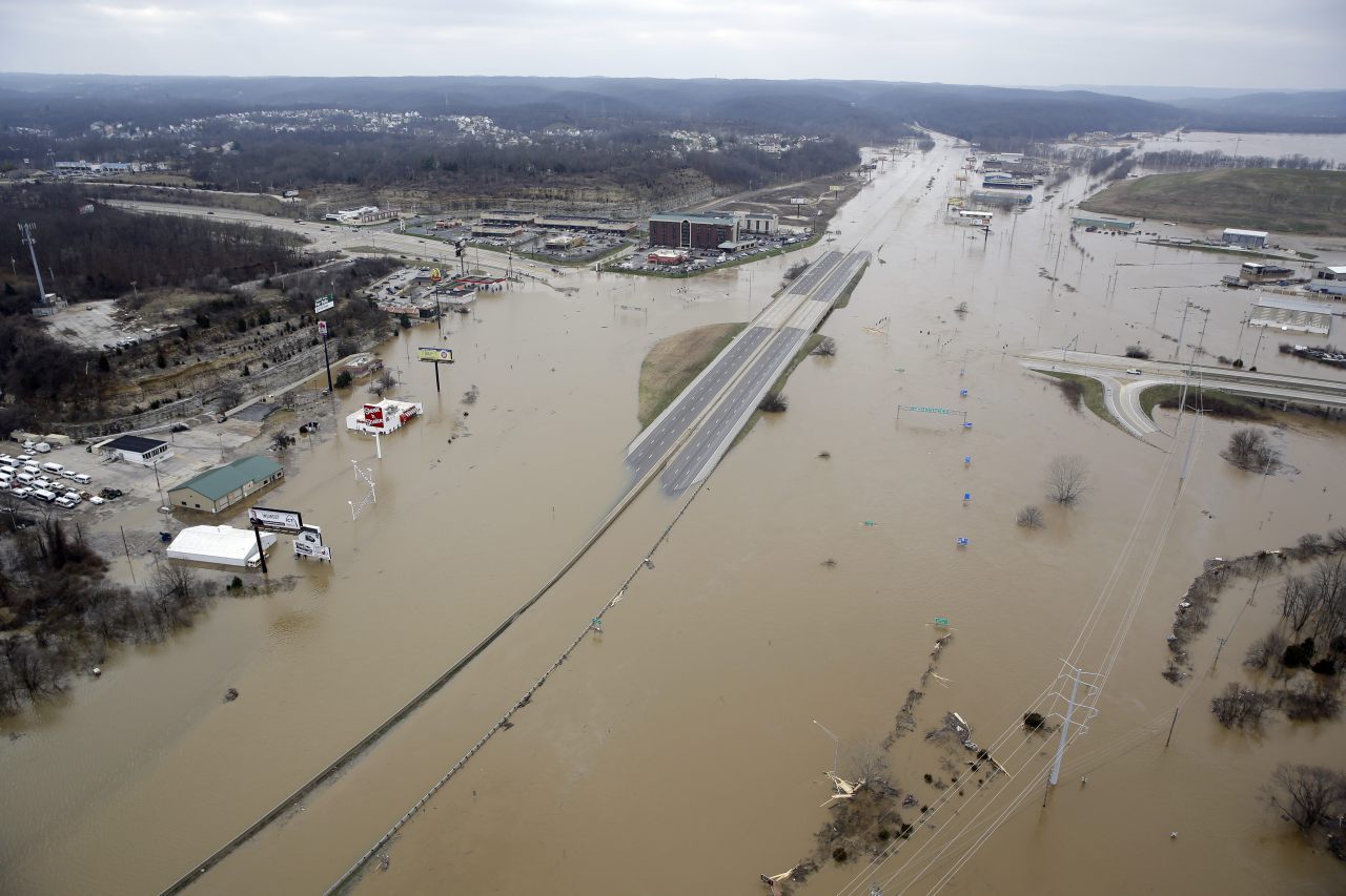
In this aerial photo, flood water covers Interstate 44, on Wednesday, Dec 30, 2015, in Valley Park, MO. A rare winter flood threatened nearly two dozen federal levees in Missouri and Illinois on Wednesday as rivers rose, prompting evacuations in several places. (AP Photo/Jeff Roberson)
4:05 pm ET: The latest from the Associated Press:
ST. LOUIS (AP) — A rare winter flood threatened nearly two dozen federal levees in Missouri and Illinois on Wednesday as rivers rose, prompting evacuations in several places.
The U.S. Army Corps of Engineers has deemed 19 levees highly vulnerable to flooding; by midday, those levees, all under close scrutiny, were holding up.
But people were moving out just in case, including the St. Louis suburb of Valley Park, where Mayor Michael Pennise ordered mandatory evacuations for 350 to 400 homes and dozens of businesses in the section of town near the fast-rising Meramec River.
Swollen rivers and streams have been pushed to heights not seen since the massive 1993 floods in some places. At least 20 deaths over several days in Missouri and Illinois were blamed on flooding, mostly involving vehicles that drove onto swamped roadways, and at least two people were still missing Wednesday.
And search teams went out for a third day in hopes of finding a country music singer from Arkansas who disappeared while duck hunting in a flooded area in northern Oklahoma. The floodwaters there also destroyed a leftover film set used in the 2003 remake of “Where the Red Fern Grows.”
Some parts of interstates in Missouri reopened Wednesday, while others – including Interstate 44 near Valley Park – were still covered by water. Missouri Gov. Jay Nixon has activated the National Guard to assist with security in evacuated areas and to help keep road closure sites clear.
Valley Park City Attorney Tim Engelmeyer called the governor’s office to send troops to help in the evacuated area of the about 7,000-person town. He was also watching computer projections of the crest – expected to be about 3 feet higher than the record of 40 feet on Thursday – knowing that an unexpected upgrade could be enough to send water over the levee.
“We’re so close,” he said. “We’re talking about a potential 6-inch difference.”
Pennise said the corps is confident the levee, built in 2007, is safe, but ordered evacuations as a precaution.
“You don’t want to think negative, but we’d rather save a life than a couch,” Pennise said.
Becky Bode, a 54-year-old postal carrier whose route includes lower Valley Park, said the area used to flood so frequently that residents mostly had flood insurance. With the levee, many don’t.
Still, she’s not worried about the residents.
“They’ve been through it before,” Bode said. “If it floods, they’ll pop back up and get going again.”
In the southwestern Missouri tourist mecca of Branson, residents of about 150 duplexes and homes had to evacuate Wednesday due to flooding from a manmade lake. But the shopping district along the lake was still open, Fire Chief Ted Martin said, adding, “it has been packed with people, and I don’t know where all of them have come from.”
Sixty miles to the north in Pleasant Hope, the emergency management director said crews are looking for a missing motorist.
“Nobody that is living has ever seen anything like this,” Rick Davis said.
Three-day rainfall totals of 9 to 11 inches were records in some parts of an area that stretched from southwest to east-central Missouri, said Mark Fuchs, a hydrologist for the National Weather Service in St. Louis. Rainfall totals of that magnitude occur only every 100 to 300 years, according to rainfall frequency data from the National Oceanic and Atmospheric Administration.
The Mississippi River is expected to reach nearly 13 feet above flood stage on Thursday at St. Louis, which would be the second-worst flood on record, behind only the devastating 1993 flood.
In the historic riverfront city of Alton, Illinois, some downtown business owners continued to scramble Wednesday to keep out rising water from the Mississippi River.
Most of the damage in the city 15 miles north of St. Louis, a stop on the 19th Century Underground Railroad, was confined to high water in some basements. Firefighters and emergency road crews worked to pump out water from flooded storm drains behind a seven-foot-high, 1000-foot-long temporary retaining wall reinforced by gravel and sandbags.
The Argosy Alton casino, which shut down on Monday, remained closed. So did the southbound lane of the main highway connecting the city to Missouri.
Alton Mayor Brant Walker said he’s “very optimistic that what we’ve built here will hold” as the Mississippi River is expected to crest at 38 feet on Thursday, 17 feet above flood stage.
That confidence was of little consolation to Tim Meeks, who was loading vats of gourmet olive oil from his downtown market onto a trailer headed to higher ground as other employees worked to drain a basement filled with 7 feet of standing water.
“We don’t keep anything down there anymore,” he said. “All of our product has to go.”
2:10 pm CST: The latest from the Associate Press reporting from St. Louis:
Missouri Gov. Jay Nixon says he’s optimistic the eastern and southern portions of the state will soon recover from devastating flooding but cautions “we’re not over this.”
Nixon toured flooded areas near the St. Louis-area community of Pacific on Wednesday afternoon. That came just hours before the Meramec River’s scheduled crest at more than 18 feet above flood stage, just short of a 1982 record.
Fourteen Missouri deaths have been blamed on the flooding since last Friday, none of them in Pacific.
Nixon noted that river crests elsewhere were occurring or expected within days, and that with no rain in the immediate forecast he hope the subsiding of the rivers goes quickly.
Nixon promised tight security at places where there have been evacuations, including in Pacific and in nearby Valley Park. And he’s unaware of any reports of looting.
3:08 pm ET: The Southeast Missourian reports:
The National Weather Service forecast the [Mississippi] river would crest at 49.7 feet in Chester [Illinois] on Friday, matching the previous record set in 1993. At that stage, the crest would be barely lower than the top of the 50-foot levee on the Missouri side. The local levee district has been working with the Army Corps of Engineers to add rock to low sections of the Bois Brule levee to help hold back the high water.
They list the other Mississippi River predicted crests as:
Cape Girardeau: 48.5 feet, 16.5 feet above flood stage, Jan. 2
Thebes, Illinois: 47.5 feet, 15.5 feet above flood stage, Jan. 2
Cairo, Illinois: 59 feet, 19 feet above flood stage, Jan. 5
New Madrid, Missouri: 47 feet, 13 feet above flood stage, Jan. 5
Caruthersville, Missouri: 46 feet, 14 feet above flood stage, Jan. 6
The Latest from the Associated Press (all times local):
1:15 pm CST:
A leftover film set used in the 2003 remake of “Where the Red Fern Grows” has been destroyed by severe flooding in northeastern Oklahoma.
A barn and a cabin built on property owned by Oklahoma Scenic Rivers Commission administrator Ed Fite was washed away, and pieces of the oak structures are scattered in tree lines and pastures.
The original 1974 film based on the classic Wilson Rawls children’s novel was also shot on Fite’s property. After filming wrapped up on the remake, Fite says he convinced filmmakers to leave the buildings behind.
Fite estimated Wednesday that thousands of tourists, college students and vacationers have visited the iconic site.
The severe rains and flooding are blamed for at least five deaths and more than 100 injuries in Oklahoma.
1:00 pm CST:
The U.S. Army Corps of Engineers says it is not planning to open a southeastern Missouri floodway in response to the swollen Mississippi River — at least not yet.
The corps put the floodway near Charleston, Missouri, to use in 2011, blasting holes in the Birds Point levee to displace enough water to save nearby Cairo, Illinois, from a potentially devastating flood.
Cairo is at the confluence of the Ohio and Mississippi rivers. In 2011, the Ohio there crested a record 22 feet above flood stage before the floodway was thrust into use, swamping 130,000 acres. Several Missouri homes were destroyed.
But the corps says the crest at Cairo would need to reach 20 feet above flood stage. And as of midday Wednesday, the river was expected to peak a foot below that late Sunday or early Monday.
12:40 pm CST:
Business owners in the historic riverfront city of Alton, Illinois, are scrambling to keep out rising water from the Mississippi River.
Most of the damage by Wednesday afternoon was confined to high water in some downtown basements. City firefighters worked to unclog flooded storm drains behind a seven-foot-high, 1,000-foot-long temporary retaining wall reinforced by gravel and sandbags.
The Argosy Alton casino remains closed, as does the southbound lane of the main highway connecting the city to Missouri.
Alton Mayor Brant Walker said he’s “very optimistic that what we’ve built here will hold” as the Mississippi River is expected to crest at 38 feet on Thursday, 17 feet above flood stage.
2:17 pm ET: The following is aerial footage taken by a drone camera showing the flood damage at MarVal Resort in Gore, Oklahoma, from water being released by Tenkiller Ferry Lake:
2:04 pm ET: FOX News reports that 7,000 people have been evacuated, as the flood water is continuing to rise and is expected to reach a crest of 46 feet.
1:27 pm ET: The St. Louis Post-Dispatch reports on the shutdown of Interstate 44:
Floodwaters from the Meramec River forced the shutdown of all lanes of Interstate 44 for a 24-mile stretch early Wednesday. The closure could last through Friday.
Ten miles of the interstate were closed at about 1:15 a.m. Wednesday between Bowles Avenue in Fenton to Highway 109 in Eureka. Then, before 9 a.m., the shutdown doubled in size, to 20 miles — extending all the way from Bowles to Highway 100 in Gray Summit. Less than an hour later, it was extended east to Interstate 270.
About 100,000 vehicles a day travel Interstate 44 near Highway 141.
1:18 pm ET: Blythe Bernhard with the St. Louis Post-Dispatch reports on health hazards caused by the flooding:
Rainwater runoff at Bridgeton Landfill and West Lake Landfill is being tested for radioactive contamination: https://t.co/4S0Au9ioaz #stlwx
— Blythe Bernhard (@blythebernhard) December 29, 2015
Flood waters in St. Louis contaminated with sewage and hazardous materials pose health risks to people, pets: https://t.co/AhiON9Vnve #stlwx
— Blythe Bernhard (@blythebernhard) December 29, 2015
1:15 pm ET: The Twitter account for a local activist group is posting images allegedly showing radioactive contamination at an area landfill in Missouri caused by the flooding:
Water gushing offsite from the radioactive surface contamination at West Lake Landfill @RepEdWhitfield @RoyBlunt pic.twitter.com/TDoxG0Xk0g
— West Lake Landfill (@Westlakelandfil) December 29, 2015
Radiological RUNOFF at #WestLakeLandfill @LacyClayMO1 pic.twitter.com/goLEqJmY3r
— Robbin Dailey (@RealMommaBird) December 28, 2015
1:02 pm ET: Fox2 in Eureka, MO, reports with video of the rescue of a man and dog from the roof of a home floating down the Mermec river after being knocked off its foundations.
The following videos detail the extent of the damage in Missouri:
https://www.youtube.com/watch?v=vIVMSXlJzeU&feature=youtu.be
The Latest from the Associated Press (all times local):
12:15 pm CST:
Authorities have confirmed a 14th Missouri flooding victim.
The latest victim was found Wednesday in Crawford County. Missouri Department of Public Safety spokesman Mike O’Connell says the victim died when a vehicle was swept off a roadway. The name of the victim wasn’t immediately released.
All but one of the Missouri victims have died when their vehicles drove into flooded roadways.
Searches for missing people also are underway in Polk and Vernon counties.
11:55 am CST:
Major rivers in flood-prone areas of Missouri and Illinois are creeping toward milestone or near-record crests.
Forecasters said the Mississippi River in St. Louis is expected to crest Thursday evening at 13 feet above flood stage — six feet below the 1993 record.
In Chester, Illinois, about 60 miles south of St. Louis, the river is expected to reach a near-record 20 feet above flood stage on New Year’s Day.
Record crests of the Meramec River near the flood-prone St. Louis suburbs of Arnold and Valley Park were expected Thursday or early Friday.
11:50 am CST:
Leaders in the central Illinois village of Kincaid say flood waters have significantly damaged 30 to 40 homes.
Kincaid Village Foreman Pat Durbin tells the Taylorville Daily Breeze-Courier (https://bit.ly/1nsYroS ) that most of the water in the area is more than 8 feet deep.
The National Weather Service says the three-day rain total in Kincaid was more than 6 inches as of Wednesday morning.
Durbin says most residents in the affected area left and he isn’t aware of any injuries. He says authorities went door-to-door and “got everybody out that we could.”
Christian County Emergency Management Agency Director Mike Crews says an American Red Cross temporary shelter is available at a high school.
Kincaid is about 25 miles southeast of Springfield and near the South Fork River.
11:30 am CST:
Floodwaters have limited access in and out of the St. Louis suburb of Valley Park.
The community of about 7,000 residents sits along the fast-rising Meramec River, which is expected to crest Thursday more than 3 feet above its previous record of 40 feet.
Mayor Michael Pennise ordered residents in one part of town to evacuate by 10 a.m. Wednesday.
He said that the U.S. Army Corps of engineers say they’re confident that the levee built in 2007 will hold, but that the evacuations were done as a precaution.
John Anderson, a Valley Park resident, cleared out his apartment building of precious item, including photos.
City attorney Tim Englemeyer asked the governor’s office to send National Guard troops to help with security.
9:55 am CST:
Crews in northern Oklahoma have begun their third day of searching for a country music singer from Arkansas who disappeared Sunday while duck hunting with a friend in severe weather.
Craig Strickland went missing after going duck hunting with his friend, Chase Morland, on Oklahoma’s Kaw Lake. Search teams found the pair’s capsized boat Sunday along with Strickland’s dog, which was alive. Morland’s body was recovered Monday.
Strickland is the lead singer of the Arkansas-based country-rock band Backroad Anthem. The band had been scheduled to perform Thursday in Little Rock, Arkansas, but that show has been canceled.
Crews searched Monday and Tuesday for Strickland but suspended the search at nightfall. The search picked back up Wednesday morning on Kaw Lake, which is 38 miles long and is near Oklahoma’s border with Kansas.
9:45 am CST:
Some traffic on Interstate 44 in central Missouri is moving again, but a stretch near St. Louis is still closed because of flooding.
The Missouri State Department of Transportation announced Wednesday that eastbound lanes reopened in Phelps County near Rolla, but westbound traffic remains closed.
Interstate 44 in southwest St. Louis County was shut down late Tuesday in both directions and is expected to remain closed for several days. Water from the Meramec River is flooding the highway at Valley Park.
Transportation officials are urging motorists to use Interstate 70 for east-west travel.
Hundreds of other road closures are occurring throughout the Midwest due to record and near-record flooding spurred by heavy rains in recent days.
9:05 am CST:
A rain-swollen lake near the tourist community of Branson, Missouri, has forced residents of 55 duplexes and about 100 single-family homes to be evacuated.
Branson Fire Chief Ted Martin says Lake Taneycomo is at fault and that there have been no injuries from the flooding, which has also closed three parks and a city-owned lakeside campground.
Branson’s popular Landing shopping district along the lake was open Wednesday, though floodwaters swamped lower areas of parking and storage.
The U.S. Army Corps of Engineers is easing water levels at a record flow around the Table Rock Lake dam, which feeds into man-made Lake Taneycomo and is contributing to the flooding.
8:05 am CST:
Volunteers are resuming a search for a missing motorist in southwest Missouri.
Pleasant Hope emergency management director Rick Davis says the man disappeared Saturday night as he prepared to cross a bridge over the Pomme de Terre River in Polk County. Guardrails kept the man’s vehicle from washing away.
Davis says volunteer firefighters searched from Sunday through Tuesday, and others are taking over the search Wednesday.
Davis says the river is normally 60 to 70 feet wide, but is now a mile wide in some spots. He says some debris piles are two stories high.
He says that, “Nobody that is living has ever seen anything like this.”
7:45 am CST:
The mayor of the St. Louis suburb of Valley Park is ordering mandatory evacuations for a portion of the town of about 6,900 residents as the fast-rising Meramec River threatens a levee.
Mayor Michael Pennise ordered the evacuations early Wednesday. Many people had already left that area but those who didn’t were told to evacuate by 10 a.m. Wednesday.
The National Weather Service is projecting that the Meramec River will reach record heights at Valley Park, around 30 feet above flood stage, late Wednesday. Pennise says the Corps of Engineers is confident the levee will hold up, and no signs of a breach have been found.
The Meramec is expected to shatter flood records at Valley Park and several other towns.
7:35 am CST:
Interstate 44 is closed in multiple locations in Missouri because of flooding.
The Missouri Department of Transportation says the closures include westbound and eastbound stretches of the interstate in central Missouri’s Phelps County and in the St. Louis area.
Transportation officials say drivers using detour routes should expect delays and longer travel times.
The interstate has been closed off and on since Monday in Phelps County.
6:55 am CST:
Two central Illinois residents have drowned in floodwaters, raising the state’s death toll since the weekend to seven.
Also, Illinois Gov. Bruce Rauner has issued a disaster proclamation for seven counties.
Christian County officials say a man and a woman were found Tuesday morning in floodwaters about 6 miles east of Edinburg. Officials say it appears they were trying to cross a flooded area. Police used cellphone location services to find them, but their minivan is still missing.
The Christian County Coroner’s Office told the (Springfield) State Journal-Register (https://bit.ly/1YO7Mha ) that both died of drowning.
Rauner issued the disaster proclamation Tuesday afternoon for Calhoun, Jackson, Jersey, Madison, Monroe, Randolph and St. Clair counties. The National Weather Service says those counties saw about 7 inches of rain Dec. 23-28.
___
LOUIS (AP) — Though the Mississippi River and its tributaries didn’t top the 19 vulnerable levees that federal officials were monitoring, the dangers from a rare winter flood remained throughout Missouri and parts of Illinois on Wednesday.
Swollen rivers and streams pushed to near-record heights, which a day before caused an unknown number of inmates to be transferred out of an Illinois state prison and prompted a disaster declaration by Illinois’ governor in seven counties and the activation of the National Guard by Missouri’s governor to help divert traffic from submerged roads.
At least 20 deaths over several days in Missouri and Illinois were blamed on flooding, mostly involving vehicles that drove onto swamped roadways, and at least two people were still missing Wednesday. Some parts of interstates in Missouri reopened, while others were still covered by water.
In southwestern Missouri, residents of about 150 duplexes and homes in the tourist town of Branson had to evacuate Wednesday when flooding from a manmade lake threatened. But the shopping district along the lake was still open, Fire Chief Ted Martin said, adding, “it has been packed with people, and I don’t know where all of them have come from.”
Record flooding was projected in some Mississippi River towns after several days of torrential rain that also caused sewage to flow unfiltered into waterways.
The Meramec River near St. Louis was expected to get to more than 3 feet above the previous record by late this week. The river on Tuesday spilled over the top of the levee at West Alton, Missouri, about 20 miles north of St. Louis. Mayor William Richter ordered any of the town’s approximate 520 residents who had not already evacuated to get out of harm’s way.
Across the river, in Alton, Illinois, dozens of volunteers helped place sandbags ahead of where water is expected to rise. Mayor Brant Walker said in a statement that flooding was expected at least in the basements of the downtown business district.
The normally docile Bourbeuse River reached the roofs of a McDonald’s, QuikTrip and several other businesses in the eastern Missouri town of Union, where the river reached an all-time high Tuesday.
Interstate 44, which had been closed on and off for the past few days, was closed Wednesday in southwest St. Louis County, but the westbound side of the interstate near the central Missouri town of Rolla reopened. Hundreds of smaller roads and highways were also closed across the two states, and flood warnings were in effect.
Missouri Gov. Jay Nixon activated the National Guard to assist with security in evacuated areas and to help keep road closure sites clear.
In southern Illinois, the Department of Corrections transferred an unspecified number of inmates from a state prison to other locations because of flooding risks. The facility houses nearly 3,700 inmates.
In St. Louis, more than 500 volunteers turned out in blustery, cold conditions to fill sandbags where a flooded waterway threatened hundreds of homes. The city later trucked 1,500 of the sandbags south to a nearby county to fortify a wastewater treatment plant threatened by the swollen Big River.
The Mississippi River is expected to reach nearly 15 feet above flood stage on Thursday at St. Louis, which would be the second-worst flood on record, behind only the devastating 1993 flood.
The high water was blamed on the shutdown of a wastewater treatment plant on Monday just south of St. Louis, causing sewage to go directly into nearby rivers and streams. The Metropolitan Sewer District of St. Louis said the Fenton wastewater treatment plant, which is designed for 6.75 million gallons per day of flow, was treating nearly 24 million gallons per day at the time of the malfunction.
One of the two wastewater plants in Springfield, Missouri, also failed, allowing partially treated sewage to flow into a river.
The U.S. Coast Guard closed a 5-mile portion of the Mississippi River near St. Louis due to flooding. Capt. Martin Malloy cited high water levels and fast currents in the river, which is a vital transportation hub for barges that carry agricultural products and other goods.
In central and southern Illinois, major flooding was occurring along the Kankakee, Illinois, Sangamon and Vermilion rivers.
In Granite City, Illinois, about 30 residents of a flooded trailer park idled in a Red Cross emergency shelter in a church basement. The park’s property manager told Shirley Clark, 56, and other displaced residents that it could be another 10 to 12 days before they’re able to return to their homes.
“We need help over here,” said Clark, a diabetic who said she left behind her insulin supply. “We’re just holding on.”
COMMENTS
Please let us know if you're having issues with commenting.