
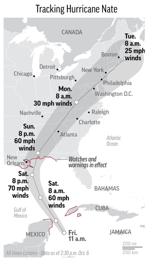
Hurricane Nate made landfall late Saturday and now the storm is making its way up the Eastern Seaboard as those in the Gulf Coast are dealing with its aftermath.
UPDATE 11 a.m. ET: Nate remnants now soaking the Mid-Atlantic.
Remnants of Hurricane Nate moving through Delaware Monday https://t.co/cFb2Ydr3Zu pic.twitter.com/lrc7jLd8cS
— Delaware Online (@delawareonline) October 9, 2017
UPDATE 9 a.m. ET Monday: Hurricane Nate’s price tage: $500 million.
JUST IN: Insured loss in U.S. from Hurricane Nate will be close to $500 million: Karen Clark & Co.
— Reuters U.S. News (@ReutersUS) October 9, 2017
UPDATE 11 p.m. ET: U.S. 90, a major east-west highway that runs parallel to the Mississippi Gulf Coast, is opening back up to traffic after Nate’s landfall made the road impassable.
Traffic flowing on Hwy 90. Drivers across South MS should still watch for debris & downed power lines:https://t.co/AFcTwet65J #Nate @wlox pic.twitter.com/IzNkSbX4xI
— Wesley Williams (@WesWilliamsII) October 9, 2017
UPDATE 10:45 p.m. ET: At least 18 tornados from Nate reported in the Carolinas.
The remnants of #Nate produced several tornadoes across parts of the NC and SC today. Preliminary Reports >> pic.twitter.com/PVlpAXCyaX
— KSLA First Alert Weather (@KSLAWeather) October 9, 2017
UPDATE 10:15 p.m. ET: Power has been restored to Mississippi Power customer that had outages from Nate’s arrival. Around 33,000 customers of Singing River Electric remain in the dark.
Thousands still in the dark in South MS after #Nate:https://t.co/L5TV97QDhw @WLOX pic.twitter.com/9MKWaG0ate
— Wesley Williams (@WesWilliamsII) October 9, 2017
Mississippi Power has completed restoration to all customers who experienced outages from #Nate: https://t.co/nHeEbTIxZI
— Mississippi Power (@MS_Power) October 9, 2017
UPDATE 10 p.m. ET: Watch drone footage of piers along Mobile Bay near Fairhope, AL that sustained damage from Hurricane Nate
VIDEO: Amazing Drone Footage of the Piers in Fairhope https://t.co/Gq1i33KBnb
— WKRG (@WKRG) October 8, 2017
UPDATE 9:30 p.m. ET: Remnants of Nate are moving through Pennsylvania and into New York State.
Rain from #Nate rapidly moving NE thru W PA. Should be in CNY between mid- 2 am Monday. #nywx pic.twitter.com/SHNZ4YUQ0L
— Jim Teske (@JimTeskeNC9) October 9, 2017
UPDATE 8:30 p.m. ET: Power outages still plague Alabama’s major population centers Birmingham and Mobile
@alabamapower shows Mobile and Jefferson counties with the greatest number of outages #mobwx #alwx #Nate pic.twitter.com/3I7RE7vsgd
— Bob Grip (@Bob_Grip) October 9, 2017
UPDATE 7 p.m. ET: Watch NOAA satellite’s capture of the fast moving storm —
NOAA #GOES16 captured the path of #Nate this weekend as it formed a hurricane and made landfall on the US @ https://t.co/oVYhIsjXNx pic.twitter.com/1OTQbDjTON
— NOAA Satellites (@NOAASatellites) October 8, 2017
UPDATE 6 p.m. ET: Tropical depression Nate leaving a footprint in the Upstate South Carolina, Western North Carolina. Power outages reported, tornado warnings underway.
TORNADO WARNINGS in effect for Union, Spartanburg & Cherokee Counties Seek shelter if inside the red polygons. pic.twitter.com/loNRGXrOQi
— FOX Carolina News (@foxcarolinanews) October 8, 2017
Hundreds without power in western NC; reports of trees down https://t.co/cUXWvEa0Ke
— FOX Carolina News (@foxcarolinanews) October 8, 2017
UPDATE 3:45 p.m. ET: The remnants of Nate are leaving a path of damage as it moves further inland.
Many trees are down across Alabama… photos from Bill Castle/ABC 33/40 pic.twitter.com/a4dFOt6asa
— James Spann (@spann) October 8, 2017
At my in laws @ 11:00 in Trussville. Deck, part of chimney, & gutter gone. No one hurt! Pics are after it was taken off house. @spann #alwx pic.twitter.com/fbIiEDA9Qn
— Lauren Blake (@Lauren_L_Blake) October 8, 2017
Storm damage in Trussville #alwx
Gallery: https://t.co/Y6uknHYz0i pic.twitter.com/Wva9tX13EF— ABC 33/40 News (@abc3340) October 8, 2017
Two trees fell on house in Jemison Sat night. Homeowner was watching Bama game at son's house when Tornado Warning was issued. pic.twitter.com/F1Cs76hwhv
— Stoney Sharp (@StoneySharp3340) October 8, 2017
Tree damage in Hoover @WBRCnews #ALwx pic.twitter.com/bghXgUu1O1
— Wes Wyatt (@weswyattweather) October 8, 2017
10:05am- Winds on Shades Mntn in Hoover gusting to around 40mph #alwx #nate @spann @CharlesDanielWx @Nate_HH @weswyattweather @NWSBirmingham pic.twitter.com/LAtzlfy0YP
— Clay Barnett (@ClaytonEBarnett) October 8, 2017
UPDATE 2 p.m. ET: More images of storm damage from Nate along the southeastern Gulf Coast
Cedar Point pier took a whipping! #HurricaneNate pic.twitter.com/hk51Q7sQNY
— Sean Sullivan (@fmtalk1065) October 8, 2017
The aftermath of hurricane Nate in fairhope al! @spann @FOX10News @TheWeatherStn @weatherchannel @WeatherNation pic.twitter.com/fM1DZjf1A8
— Jacob Gaines (@RealJacobGaines) October 8, 2017
Panorama of Cedar Point pier now. Nate wrecked it. @spann @washingtonpost pic.twitter.com/ttmfur08KX
— Carmen Sisson (@CarmenSisson) October 8, 2017
Surf still at 7-9 feet with swells as high as 10 feet at Pensacola Beach. Gulf waters closed to swimming and wading. #Nate @spann @NWSMobile pic.twitter.com/AApteFltMw
— Brantly Keiek (@BrantlyWx) October 8, 2017
Beloved South Mobile County Fishing Spot Heavily Damaged by Nate https://t.co/po3jfXnYTv
— WKRG (@WKRG) October 8, 2017
MFRD’s Morning Rescues in Nate Flooding https://t.co/5PYB2hJXss
— WKRG (@WKRG) October 8, 2017
🚧🚘🚛Causeway still underwater & closed🌊. Bankhead tunnel is still closed as well @mynbc15 pic.twitter.com/9OmvFWyD0i
— Kelly Foster (@Kelly_WPMI) October 8, 2017
UPDATE 1:40 p.m. ET: 146k power impacted by Nate per Alabama Power, 32k impacted in Mississippi per the Sun-Herald (MS).
Noon Update: so far, Nate has interrupted service to nearly 146,000 customers. We have already restored service to more than 58,000.
— Alabama Power (@alabamapower) October 8, 2017
More than 32,000 power customers on the Mississippi Coast have no service https://t.co/qE0m0hHS9c
— Robin Fitzgerald (@robincrimenews) October 8, 2017
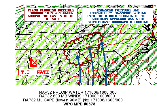
UPDATE 1:30 p.m. ET: NOAA’s Weather Prediction Center issues advisory on Tropical Depression Nate for parts of Georgia, South Carolina and North Carolina.
MESOSCALE PRECIPITATION DISCUSSION 0878
NWS WEATHER PREDICTION CENTER COLLEGE PARK MD
131 PM EDT SUN OCT 08 2017

AREAS AFFECTED...NORTHEAST GA...NORTHWEST SC...WESTERN NC...FAR
EASTERN TN

CONCERNING...HEAVY RAINFALL...FLASH FLOODING POSSIBLE

VALID 081730Z - 082330Z

SUMMARY...VERY HEAVY RAINS ARE EXPECTED OVER THE NEXT SEVERAL
HOURS OVER THE HIGHER TERRAIN OF THE SOUTHERN APPALACHIANS. SOME
FLASH FLOODING WILL BE POSSIBLE.

DISCUSSION...T.D. NATE CONTINUES TO LIFT QUICKLY NORTH-NORTHEAST
UP ACROSS WESTERN AL AND SHOULD MOVE UP ACROSS SOUTHERN TN BY
AROUND 21Z. THERE CONTINUES TO BE A VERY STRONG INFLUX OF DEEP
TROPICAL MOISTURE ALONG WITH ENHANCED SURFACE CONVERGENCE AROUND
THE EASTERN SEMICIRCLE OF NATE...WITH MULTIPLE BANDS OF WELL
ORGANIZED CONVECTION. THE STRONGEST CONVECTIVE BAND EXTENDS FROM
FAR SOUTHEAST TN SOUTHWARD DOWN ACROSS MUCH OF CENTRAL GA WITH A
LINEAR AXIS OF VERY INTENSE RAINFALL RATES. THE INDIVIDUAL CELL
MOTION IS RAPIDLY OFF TO THE NORTH...BUT THERE IS A BRIEF PERIOD
CELL-TRAINING OCCURRING AS THE OVERALL BAND SHIFTS GRADUALLY TO
THE NORTHEAST.

THE LATEST RAP GUIDANCE FAVORS A SOUTHEAST LOW LEVEL JET OF 50 TO
60 KTS AIMING INTO THE HIGHER TERRAIN OF THE SOUTHERN APPALACHIANS
THIS AFTERNOON WITH AN EMPHASIS ON NORTHEAST GA...NORTHWEST SC AND
WESTERN NC WHILE THE CENTER OF NATE BEGINS TRACKING UP THROUGH THE
TN VALLEY. THE CIRA-LPW DATA SHOWS AND ALREADY VERY MOIST
ENVIRONMENT WITH PWATS JUST OVER 2 INCHES...BUT THESE VALUES WILL
LIKELY INCREASE FURTHER WITH A NOSE OF 2.25 TO 2.5 INCH PWATS
EXPECTED TO NOSE UP ACROSS THE SOUTHEAST PIEDMONT AND INTO THE
FAVORED SOUTHEAST FACING TERRAIN THROUGH MID TO LATE AFTERNOON.
THERE IS MUCH GREATER INSTABILITY ALSO NOTED ACROSS THE SOUTHEAST
COASTAL PLAIN WITH THE LATEST RAP ANALYSIS SHOWING A NOSE OF
MLCAPE VALUES EXCEEDING 1500 J/KG LIFTING UP ACROSS EASTERN GA
AHEAD OF THE AFOREMENTIONED CONVECTIVE BANDING.

THE MOISTURE AND INSTABILITY TRANSPORT WILL BE QUITE STRONG AND
WILL FAVOR SUSTAINABLE CONVECTIVE BANDS WITH RAINFALL RATES THAT
MAY APPROACH 3 INCHES/HR. THIS WILL BE AIDED BY OROGRAPHIC ASCENT.
DESPITE QUITE HIGH FFG VALUES...THE INTENSE RAINFALL RATES OVER
THE HIGHER TERRAIN WILL ENCOURAGE SOME RAPID RUNOFF AND MAY RESULT
IN SOME ENHANCED SHORT-TERM FLASH FLOODING CONCERNS. EXPECT
RAINFALL TOTALS THROUGH 00Z OF AS MUCH AS 4 TO 6+ INCHES. WILL
CONTINUE TO MONITOR.
UPDATE 12:30 p.m. ET: Trump approves Alabama governor’s disaster declaration.
President Trump Approves Gov. Ivey’s Presidential Emergency Declaration https://t.co/71lPw6gt7x
— WKRG (@WKRG) October 8, 2017
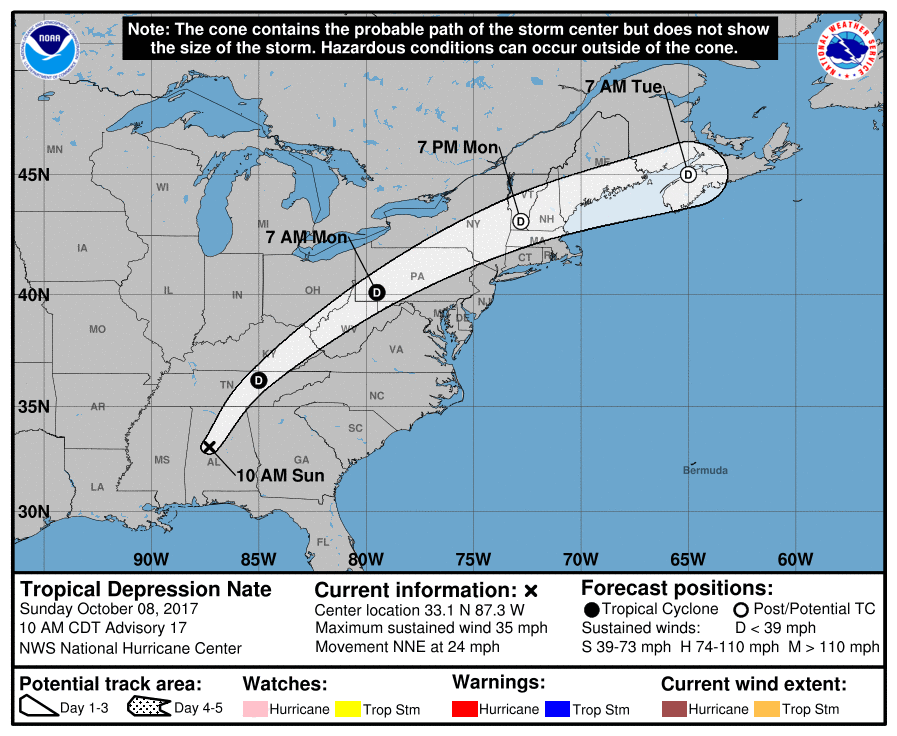
UPDATE 11:15 a.m. ET: Nate downgraded to a tropical depression.
The National Hurricane Center’s latest advisory has the storm making its first landfall located at 33.1°N 87.3°W, moving north at 24 mph, 40 miles southwest of Birmingham, AL.
UPDATE: 10:15 a.m. ET: Tropical Storm Nate ‘rapidly weakening’ — Still poses threat inland
The National Hurricane Center’s latest advisory has the storm making its first landfall located at 32.0°N 88.0°W, moving north at 23 mph, 95 miles southwest of Montgomery, AL.
UPDATE 10 a.m. ET: 71k without power in Alabama.
8am Update: We currently have 71,000 customers without service. Most are in the Mobile area, but the effects are moving north. #ALwx
— Alabama Power (@alabamapower) October 8, 2017
UPDATE 9:45 a.m. ET: As daylight arrives, the Gulf Coast surveys damages.
Biloxi Light House Pier severely damaged by #Nate's storm surge. #mswx @WLOX @spann @NWSNewOrleans @NWSMobile pic.twitter.com/a2n3ZtVw4V
— Eric Jeansonne (@Weatheric) October 8, 2017
Caution: Rocky Road Ahead… rocks from the bulkhead reinforcement on Shell Belt Road #Nate #MobileCountySafe pic.twitter.com/GZuGZj9YUD
— Mobile County (@mobilecountyal) October 8, 2017
Live coverage Hurricane Nate damage. https://t.co/SQ41rwONUP
— Jeff Piotrowski (@Jeff_Piotrowski) October 8, 2017
Aloe bay this morning 3 ft water whole night pic.twitter.com/6QpRgfpPwp
— Dauphin Island (@dialchamber) October 8, 2017
UPDATE 7:15 a.m. ET: 59k without power in Alabama
6am Update: We are showing 59,000 customers without power; 56,000 of those are in the Mobile area. Storms still heading north. #ALwx
— Alabama Power (@alabamapower) October 8, 2017
UPDATE 7 a.m. ET: Downtown Mobile, AL under water.
Kayaking anyone? Downtown @City_of_Mobile has a little flooding from #HurricaneNate2017 #nate @weatherchannel pic.twitter.com/KUXq2DF2m3
— Michael Schubert (@Schubacabra) October 8, 2017
Still flood waters over Water and Government, also Canal@FOX10News pic.twitter.com/X9WbyaP3TI
— Steve Alexander (@SteveWALA) October 8, 2017
Flooding along Royal St. in Mobile, Alabama after Hurricane Nate rolled thru pic.twitter.com/Zne6MRg4o3
— David Begnaud (@DavidBegnaud) October 8, 2017
Off ramp of I10 to downtown @City_of_Mobile @ water st #HurricaneNate #nate #mobile pic.twitter.com/mVsllfdKYJ
— Michael Schubert (@Schubacabra) October 8, 2017
Master of his craft or man of questionable intelligence says the guy outside in a #hurricane @ 3 am #HurricaneNateِ #Mobile @City_of_Mobile pic.twitter.com/SRzojPh1Dy
— Michael Schubert (@Schubacabra) October 8, 2017
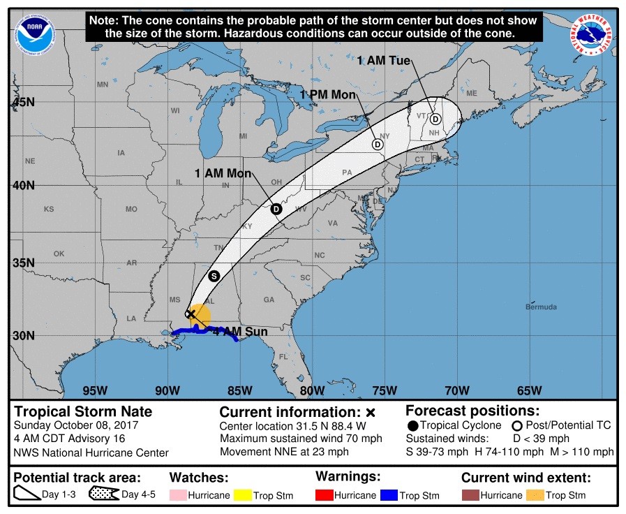
UPDATE 6 a.m. ET: Nate downgraded to a tropical storm.
The National Hurricane Center’s latest advisory has the storm making its first landfall located at 31.5°N 88.4°W, moving north at 20 mph, 135 miles south of Montgomery, AL.
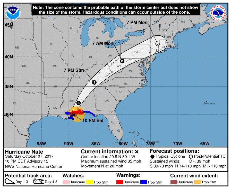
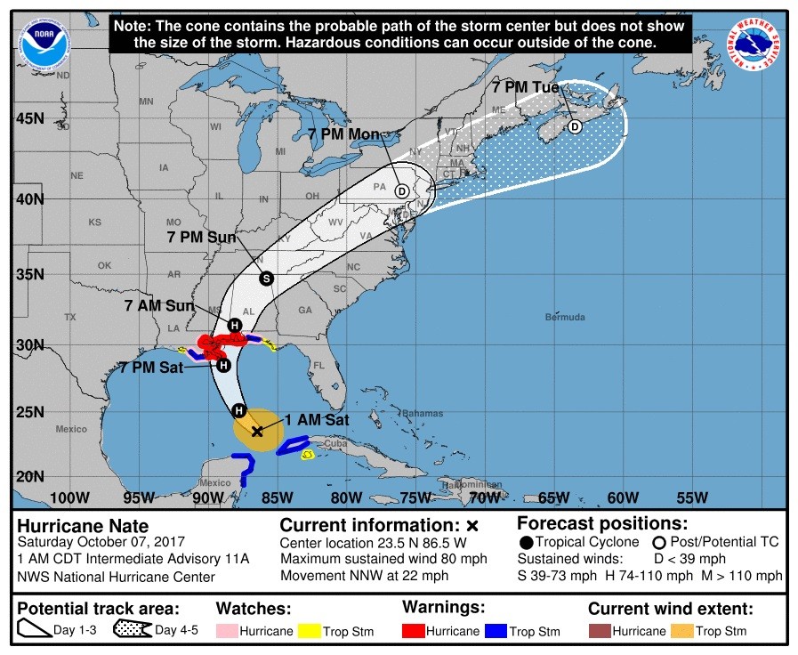
UPDATE 2 a.m. ET: Nate remains a hurricane.
The National Hurricane Center’s latest advisory has the storm making its first landfall located at 30.5°N 88.9°W, moving north at 20 mph, 5 miles north of Biloxi.

UPDATE 1:30 a.m. ET: National Hurricane Center declares Nate has made its second landfall near Biloxi, MS.
The latest data has the storm located at 30.4°N 89.0°W, inland moving north at 20 mph.
UPDATE 1 a.m. ET: More storm surge images from Biloxi, MS
Cars are crashing into one another. First deck Hard Rock in Biloxi pic.twitter.com/X8KHigI1zx
— Muriel Bailey (@MurielWPMI) October 8, 2017
Inside Hard Rock in Biloxi. pic.twitter.com/4vx35zyTCW
— Hugh Keeton (@HughKeeton) October 8, 2017
UPDATE 12:30 a.m. ET: Instances of storm surge reported along the coastlines of Mississippi and Alabama
We are fighting Hurricane force winds funneling through parking garage with #stormsurge continuing to rise in Biloxi !! #HurricaneNate !! pic.twitter.com/woX5OQa4eK
— Mike Theiss (@MikeTheiss) October 8, 2017
Storm surge is on the rise across the area. Flooding reported in Point Clear, AL. #Nate #alwx #mobwx https://t.co/w553Y2k59d
— NWS Mobile (@NWSMobile) October 8, 2017
UPDATE 12:15 a.m. ET Sunday: New Orleans spared from the brunt of Hurricane Nate
Only a couple dozen power outages in/around New Orleans from #Nate. pic.twitter.com/VqwkQGaJ1C
— Chris Bianchi (@BianchiWeather) October 8, 2017
UPDATE 11:45 p.m. ET: Power outages starting to increase along the Gulf Coast
Over 5,000 people are without power as Hurricane #Nate nears 2nd US landfall. Reports: https://t.co/EPkaMuXDOa https://t.co/nNAsjuTkgS
— AccuWeather (@breakingweather) October 8, 2017
Alabama Power reports power outages are up to 3,900 in Bayou la Batre, Downtown Mobile, Saraland and Theodore #HurricaneNate
— WKRG (@WKRG) October 8, 2017
UPDATE 11 p.m. ET: The National Hurricane Center’s latest advisory has the storm located at 29.9°N 89.1°W, moving north at 20 mph, 35 miles south of the mouth of Biloxi, MS.
UPDATE 10:30 p.m. ET: Hurricane Nate on the verge of making its second landfall
The eyewall of Hurricane #Nate is about the slam into the coasts of Mississippi and Alabama. Winds may gusts up to 70-90 mph. pic.twitter.com/wDK1idmCCM
— Hurricane Tracker App (@hurrtrackerapp) October 8, 2017
UPDATE 9:30 p.m. ET: Nate is nearing the Mississippi coast for another landfall
Here’s the latest radar loop out of New Orleans. #Nate is rapidly moving towards the MS coastline. Worst weather in north & east quadrants. pic.twitter.com/3feMNgnuDx
— Hurricane Tracker App (@hurrtrackerapp) October 8, 2017
UPDATE 8 p.m. ET: The National Hurricane Center’s latest advisory has the storm making its first landfall located at 29.0°N 89.2°W, moving north at 20 mph, 10 miles south of the mouth of the Mississippi River.
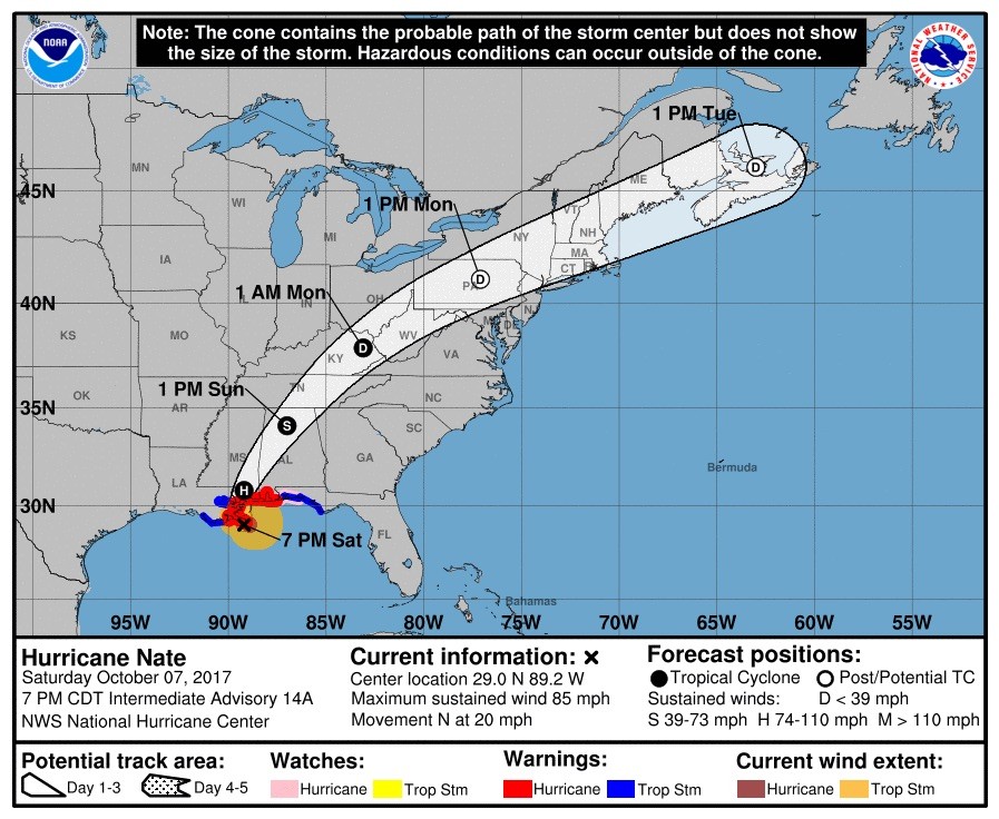
UPDATE 7:55 p.m. ET: Hurricane Nate makes first landfall near the mouth of the Mississippi River.
#Nate makes landfall near the mouth of the Mississippi River as a Category 1 storm. #LAwx #MSwx #ALwx #HurricaneNate pic.twitter.com/6b9gpDBBia
— Matthew Sewell (@_MattSewell) October 7, 2017
UPDATE 7:50 p.m. ET: Multiple tornado warnings issued along the Alabama coastline.
Multiple Tornado Warnings Issued Near The Beach Within The Last Several Minutes @spann #ALWX https://t.co/Wp5w9Q87il pic.twitter.com/xbhiVoHztZ
— AlabamaWx Weather Blog (@alabamawxblog) October 7, 2017
UPDATE 7:45 p.m. ET: The Mobile Bay Causeway in Alabama now covered in water as a result of storm surge
Causeway EB and WB is now closed. Seek alternate route. #TrafficAlert #HurricaneNate
— ALDOT Mobile Area (@ALDOTMobileArea) October 7, 2017
UPDATE 7:30 p.m. ET: Surf picks up around the Gulf Coast as Nate nears landfall.
#HurricaneNate
Pensacola Beach as hurricane approaches. @AshleyRuizWx @weartv @spann @VisitPensacola @weatherchannel @NWSMobile pic.twitter.com/Ro8amW91WH— Jimmy Sarris (@sarrisjp) October 7, 2017
Bay front rd 5:39 pm @spann pic.twitter.com/euBKXgqVYe
— scarface (@enguerrasiempre) October 7, 2017
UPDATE 6 p.m. ET: Hurricane Nate the “fastest” forward-motion moving recorded hurricane in the Gulf of Mexico according to the National Weather Service.
On the move! Nate’s 28 mph forward motion, in the last 12 hours, is the fastest recorded forward motion of a Hurricane in the Gulf of Mexico pic.twitter.com/A6spfrJxlC
— NWS (@NWS) October 7, 2017
UPDATE 5 p.m. ET: Portions of the hurricane watch in Louisiana have been canceled.
The Hurricane Watch is discontinued from west of Grand Isle to Morgan City. #Nate
— Hurricane Tracker App (@hurrtrackerapp) October 7, 2017
UPDATE 4:45 p.m. ET: The National Hurricane Center’s latest advisory has the storm located at 28.4°N 89.1°W, moving north at 23 mph, 50 miles south of the mouth of the Mississippi River.

UPDATE 3:45 p.m. ET: Hurricane Nate’s arrival at the Mississippi-Alabama state line anticipated to pack 100 mph winds, per AL.com.
Hurricane Nate expected to arrive about midnight with 100 mph winds https://t.co/Kyo7F7PL1S pic.twitter.com/de0Ak0Ejt3
— AL.com Mobile (@ALcomMobile) October 7, 2017
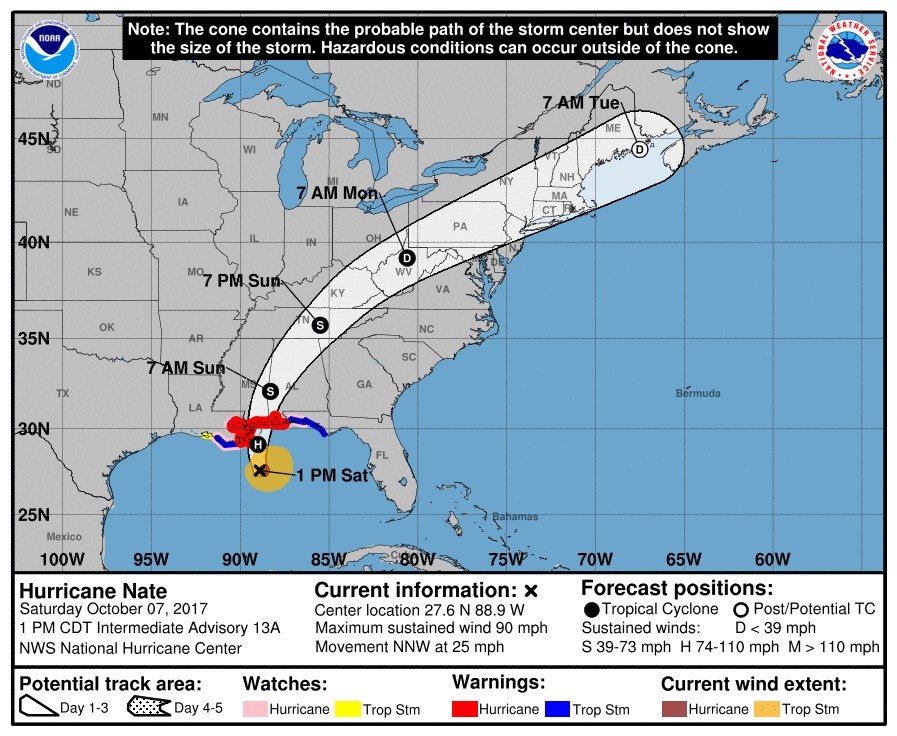
UPDATE 3:15 p.m. ET: The National Hurricane Center’s latest advisory has the storm located at 27.6°N 88.9°W, moving north at 26 mph, 105 miles south of the mouth of the Mississippi River.
UPDATE 3 p.m. ET: Waterspout spotted off the coast of Alabama, spawned from Nate. Area also under a tornado warning
https://twitter.com/sarahann1693/status/916739859787763712
Tornado Warning continues for Gulf Shores AL, Orange Beach AL, Magnolia Springs AL until 2:15 PM CDT pic.twitter.com/YX0ZMgJyVM
— NWS Tornado (@NWStornado) October 7, 2017
UPDATE 2 p.m. ET: Nearly the entire state of Alabama is under a watch or warning due to Hurricane Nate
A look at the various watches/warnings across Alabama… pic.twitter.com/5X6QPkrJ1R
— James Spann (@spann) October 7, 2017
UPDATE 1:30 p.m. ET: The National Weather Service in New Orleans emphasizes why those under mandatory evacuation orders should adhere to them.
Our 6ft 6in MIC next to 11ft poll. THAT'S how high water could get along coast MS River to MS/AL line. If under evac order, LEAVE NOW! #Nate pic.twitter.com/q15ruUyetE
— NWS New Orleans (@NWSNewOrleans) October 7, 2017
UPDATE 1 p.m. ET: Tropical storm force winds are forecasted from Louisiana to Maine.
Tropical storm conditions will move into the coast at around 2PM. By then, all preparations need to be complete. #Nate pic.twitter.com/9MOgEbdDGD
— Hurricane Tracker App (@hurrtrackerapp) October 7, 2017
UPDATE 12 p.m. ET: The National Hurricane Center’s latest advisory has the storm located at 26.6°N 88.4°W, moving north at 26 mph, 180 miles south of the mouth of the Mississippi River.
UPDATE 11:30 a.m. ET: Outer rain bands from Hurricane Nate are arriving in southeastern Louisiana.
Outer rain bands from #Nate are beginning to close in on extreme SE LA. Conditions going down hill from this point. pic.twitter.com/yToSWQ4WJd
— Hurricane Tracker App (@hurrtrackerapp) October 7, 2017
UPDATE 11 a.m. ET: Nate now expected to make landfall as a Category 2, per National Hurricane Center.
#Nate strengthening & expected to be a category 2 #hurricane at landfall along the northern Gulf Coast. More: https://t.co/tW4KeGdBFb pic.twitter.com/VGUKZRxVjg
— National Hurricane Center (@NHC_Atlantic) October 7, 2017
UPDATE 10:30 a.m. ET: Storm surge warnings remain in effect from Louisiana to Florida.
Storm Surge Watches and Warnings are in effect for portions of the coasts of Louisiana and Florida and all of Mississippi and Alabama. #Nate pic.twitter.com/EceQzQxG9S
— Hurricane Tracker App (@hurrtrackerapp) October 7, 2017
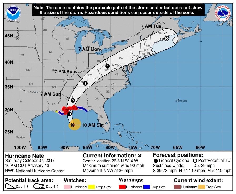
UPDATE 10 a.m. ET: The National Hurricane Center’s latest advisory has the storm located at 25.7°N 88.0°W, moving north at 22 mph, 245 miles south of the mouth of the Mississippi River.

UPDATE 9:30 a.m. ET: Hurricane Nate expected to be packing winds of 90 mph when it makes landfall later today.
he National Hurricane Center is now forecasting #Nate to be a 90 mph hurricane at landfall on the U.S. Gulf coast. pic.twitter.com/ziQEBqwcMQ
— Hurricane Tracker App (@hurrtrackerapp) October 7, 2017
UPDATE: 6 a.m. ET: The National Hurricane Center’s latest advisory has the storm located at 24.5°N 87.0°W, moving north at 22 mph, 345 miles south of the mouth of the Mississippi River.
UPDATE 3 a.m. ET: Forecasts show after Nate makes landfall, its remnants could make their way up the Eastern Seaboard and directly impact Washington, DC, Philadelphia, New York City and Boston.
UPDATE 2:30 a.m. ET: Meteorologists anticipate further strengthening by Nate as the Gulf Coast braces for Saturday evening landfall.
Hurricane #Nate continues to intensify, now 80 mph. Not liking this trend. Additional strengthening expected before Saturday PM landfall. pic.twitter.com/kQy6cJLrBq
— Ivan Cabrera (@IvanCabreraTV) October 7, 2017
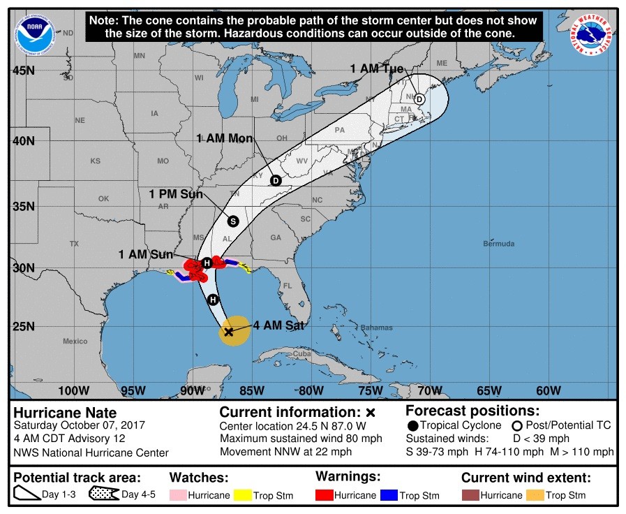
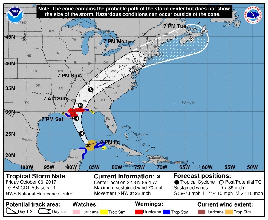
UPDATE: 1:45 a.m. ET: The National Hurricane Center’s latest advisory has the storm located at 23.5°N 86.5°W, moving north at 22 mph, 420 miles south of the mouth of the Mississippi River.
UPDATE 12:45 a.m. ET Saturday: Winds within Hurricane Nate now up to 75 mph.
Well, that was quick. Hurricane Hunter aircraft found winds of 75 MPH in the center of #Nate, making it a bona fide hurricane. @NOAA #GOES16 pic.twitter.com/fsRhMvUiMY
— NASA SPoRT (@NASA_SPoRT) October 7, 2017
UPDATE: 11:30 p.m. ET: Nate is now classified as a Category 1 hurricane per The Weather Channel.
UPDATE 11:00 p.m. ET: The National Hurricane Center’s latest advisory has the storm located at 22.3°N 86.4°W, moving north at 22 mph, 500 miles south of the mouth of the Mississippi River.
The National Hurricane Center has the watches and warnings listed as below:
SUMMARY OF WATCHES AND WARNINGS IN EFFECT:
A Hurricane Warning is in effect for...
* Grand Isle Louisiana to the Alabama/Florida border
* Metropolitan New Orleans and Lake Pontchartrain

A Storm Surge Warning is in effect for...
* Morgan City Louisiana to the Okaloosa/Walton County Line Florida
* Northern and western shores of Lake Pontchartrain

A Tropical Storm Warning is in effect for...
* Punta Herrero to Rio Lagartos Mexico
* Pinar del Rio Cuba
* Lake Maurepas
* West of Grand Isle to Morgan City Louisiana
* East of the Alabama/Florida border to the Okaloosa/Walton County
Line.

A Hurricane Watch is in effect for...
* Lake Maurepas
* East of the Alabama/Florida border to the Okaloosa/Walton County
Line
* West of Grand Isle to Morgan City Louisiana

A Storm Surge Watch is in effect for...
* East of the the Okaloosa/Walton County Line to Indian Pass Florida

A Tropical Storm Watch is in effect for...
* East of the Okaloosa/Walton County Line to Indian Pass Florida
* West of Morgan City to Intracoastal City Louisiana
* Isle of Youth Cuba
Follow Jeff Poor on Twitter @jeff_poor
COMMENTS
Please let us know if you're having issues with commenting.