Florence rapidly strengthened into a potentially catastrophic Category 4 hurricane Monday as it closed in on North and South Carolina, carrying winds and water that caused heavy rain and flash floods on the East Coast over the weekend.
The first effects were already being seen on barrier islands Monday as dangerous rip currents and seawater flowed over the state highway. People were told to prepare to evacuate communities up and down a stretch of coastline already identified as particularly vulnerable to rising sea levels due to climate change.
For many, the challenge could be finding a safe refuge: If Florence slows to a crawl just off the coast, it could carry torrential rains up into the Appalachian mountains, causing flash floods, mudslides and other dangerous weather across a wide area.
“Florence is quickly becoming a powerful hurricane,” hurricane specialist Eric Blake wrote.
“The bottom line is that there is increasing confidence that Florence will be a large and extremely dangerous hurricane, regardless of its exact intensity,” Blake said.
By noon EDT on Monday, Florence had top sustained winds of 130 mph (195 kph). It was centered about 1,230 miles (1,985 kilometers) east-southeast of Cape Fear, North Carolina, and moving west at 13 mph (20 kph). Its center will move between Bermuda and the Bahamas Tuesday and Wednesday, and approach the coast of South Carolina or North Carolina on Thursday, the National Hurricane Center said.
A warm ocean is the fuel that powers hurricanes, and Florence will be moving over waters where temperatures are peaking near 85 degrees (30 Celsius), Blake wrote. And with little wind shear to pull the storm apart, Florence’s hurricane wind field was expected to expand over the coming days, increasing its storm surge and inland wind threats, and raising the likelihood of life-threatening freshwater flooding.
As of 11 a.m. EDT, Florence was centered about 580 miles (935 kilometers) south-southeast of Bermuda, moving west at 13 mph (20 kph). Far behind Florence is Hurricane Isaac, which had maximum sustained winds at 75 mph (120 kph). Isaac was centered about 1,150 miles (1,855 kilometers) east of the Windward Islands and moving west at 14 mph (22 kph).
Dare County officials have announced that a mandatory evacuation order goes into effect on Hatteras Island at noon Monday. A mandatory evacuation for residents and visitors in other areas of the county goes into effect at 7 a.m. Tuesday. Gov. Roy Cooper (D-NC) declared a state of emergency and is urging all North Carolinians to prepare, while the state’s Division of Marine Fisheries called on fishermen to remove fishing gear from the water well prior to the storm’s arrival.
NC Gov. Roy Cooper: "The forecast places North Carolina in the bullseye of Hurricane Florence, and the storm is rapidly getting stronger."
"We here in North Carolina are bracing for a hard hit." https://t.co/FtDlwQuSWN pic.twitter.com/SJ4pyVQEQ1
— World News Tonight (@ABCWorldNews) September 10, 2018
Addie Bangel of Salvo was on her way to Chesapeake for supplies for her animals when the evacuation order for Hatteras Island was issued. Getting gas now in Grandy. pic.twitter.com/IiRW0gOBto
— Sam Walker OBX🎙📻 (@SamWalkerOBX) September 10, 2018
We just passed this sign on NC 158 heading towards the OBX – It reads "Hatteras Island Evacuation" This order is effective at 12 p.m. TODAY. Please, protect yourself and listen to the warnings https://t.co/HKwSHrkXwa via @WTKR3 pic.twitter.com/fT5HX5fl3M
— Erin Miller (@Emiller_reports) September 10, 2018
Traffic leaving Hatteras Island before the mandatory evacuation at noon. @WAVY_News pic.twitter.com/yKSlO8BYdr
— Andy Fox (@AndyFoxWAVY) September 10, 2018
As Florence barrels towards the East Coast, states across the region have been hit with heavy rain and flash floods throughout the weekend. In Virginia, Old Town Alexandria firefighters rescued at least eight residents after heavy rain flooded parts of the area. Law enforcement spent part of the weekend securing construction manholes amid concerns rains could cause residents to get “sucked-in.” The Fairfax Red Cross is helping to equip residents with food, water, and medical supplies as Florence approaches.
This Guy…
• Alexandria Old Town
• Potomac overflowing into King Street
• Police closing waterfront streets#breaking #dcwx @WUSA9 @capitalweather pic.twitter.com/tJ2tccV1mA— Mike Valerio (@MikevWUSA) September 10, 2018
Your typical flooding in Old Town Alexandria after a long day of rain. Luckily it’s not raining right now. @fox5dc pic.twitter.com/IJ8TymHNgC
— Evan Lambert (@EvanLambertTV) September 9, 2018
Tidal flooding beginning to show in Old Town Alexandria. High tide is 8:06p. pic.twitter.com/jP8uitoSlQ
— Van Applegate (@vbagate) September 9, 2018
At least 8 people rescued in Old Town Alexandria due to flooding. King St. & Union St. shut down. Just spoke to a man in this boat who slipped and fell inside a coffee shop. He is being checked out by medics. pic.twitter.com/xBDhwQAPO4
— Victoria Sanchez (@VictoriaSanchez) September 9, 2018
Lots of water in Old Town Alexandria because of the high tide and rain. I’ll have the wrap up of what happened on @ABC7News at 11 p.m. pic.twitter.com/Q6PNE3iMlj
— Victoria Sanchez (@VictoriaSanchez) September 10, 2018
Old town Alexandria, prone to flooding saw some pretty serious flashflooding last night and overnight. Sandbags are out ahead of what could be even more problems this week with potential threats from hurricane Florence. LIVE report coming up on @ABC7GMW pic.twitter.com/ELjGG0htmI
— John Gonzalez (@ABC7John) September 10, 2018
Dirt and debris still scattered about King Street after floodwater here receded here in Old Town Alexandria. With more rain forecast this week, we could see more flooding … and sandbags. https://t.co/NpyKCaswTV pic.twitter.com/KfKISwNcnM
— Justin Finch (@JustinNBC4) September 10, 2018
This is what it looks like in Old Town Alexandria Monday morning as sandbags are being used to try and control the flood waters that have swamped area streets https://t.co/DhCvZ9KxzO @fox5melanie #fox5weather pic.twitter.com/gOJef4qTPY
— FOX 5 DC (@fox5dc) September 10, 2018
What it probably looks like peddling through a flooded Old Town Alexandria
MORE: https://t.co/GvVSnCuD9C pic.twitter.com/Hl0MRIFrkR— FOX 5 DC (@fox5dc) September 10, 2018
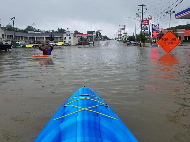
Parts of Washington, Pennsylvania, nearly 30 miles southwest of Pittsburgh, reportedly experienced 18 inches of rain. Video of residents using kayaks to paddle through West Chestnut Street circulated on social media Sunday.
South Jersey was pummeled by heavy rains, prompting law enforcement to shut down major roads near the Jersey Shore. “At one point, the flood waters were so high that the Black Horse Pike in Egg Harbor Township had been blocked off for a few hours. All lanes have since been reopened. Firefighters were also sent out to rescue those staying at the Travel Inn Motel on the 7000 block of the Black Horse Pike in Egg Harbor Township,” ABC 6 reports.
“I was laying in the bed, and all of a sudden all this water came rushing through and I had to get everything off the floor. I was hoping the water was going to start to recede, but eventually it got up so high that the mattress started to float. That’s when the fire department came and got us out,” one witness said.
An angry looking ocean this evening in Avon-By-The-Sea, New Jersey. Had a wind swept rain all day 🌧🌬🌊 pic.twitter.com/5B9NpR6ork
— Collin Gross (@CollinGrossWx) September 9, 2018
Rain, rain, go away! But in the meantime, stay safe with these wet weather driving tips: https://t.co/npPa4uE0cP pic.twitter.com/aiz8qCpuIY
— AAA South Jersey (@AAASouthJersey) September 9, 2018
Heavy rain leads to flooding at the Jersey Shore. @AClineThomas has the details: https://t.co/EBgXoFWs5s pic.twitter.com/HwwHmWdicX
— NBC10 Philadelphia (@NBCPhiladelphia) September 10, 2018
Time to pull out the rain boots and jacket. It's chilly and wet here in Jersey. @phl17 pic.twitter.com/PBjI1UvU9a
— Khiree Stewart (@khireephl17) September 10, 2018
New Jersey town grapples with flash flooding as heavy rains lash the Northeast: https://t.co/iiy2n1Jvuz pic.twitter.com/Ll13TRoI9e
— ABC News (@ABC) September 10, 2018
Jessamine County, Kentucky received up at 8 inches of rain, leaving some roads submerged in water. “Yeah we’ve turned around a couple places, I’ve seen some trucks go through but in our little car I wouldn’t even chance it so we stop and turn around,” Jessamine County resident AJ Halcomb told LEX 18.
LEX 18 reporter Katherine Collins shared a photo of a Nicholasville playground completely flooded.
“The Park is a lake.” That’s how neighbors here in Nicholasville are describing this scene. @LEX18News pic.twitter.com/EKBV2LHLw4
— Katherine Collins (@KCollinsWLEX) September 9, 2018
National Hurricane Center says Isaac is a very small hurricane and its intensity could fluctuate as it approaches the Caribbean. However, it is still expected to be at or near hurricane strength by the time it reaches the Lesser Antilles. Forecasters said Hurricane Helene was strengthening far from land over the open Atlantic, centered about 375 miles (600 kilometers) west of the southernmost Cabo Verde Islands.
The Associated Press contributed to this report.
COMMENTS
Please let us know if you're having issues with commenting.