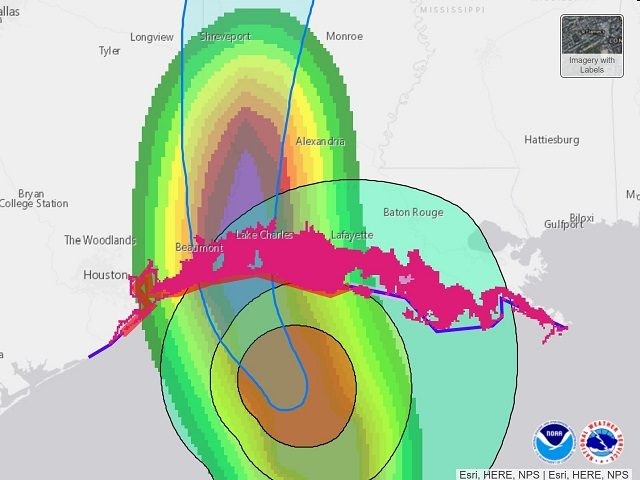
The 7 p.m. report from the National Hurricane Center indicates Hurricane Laura continues to strengthen as it approaches the Texas-Louisiana coastline. Officials now report sustained winds of 150 miles per hour.
Category 4 Hurricane Laura is located at 28.4 N and 92.9 W as of the 7 p.m. report Wednesday evening. This places the storm 120 miles south of Lake Charles, Louisiana, and 120 miles south southeast of Port Arthur, Texas. The storm has turned more toward the north as of this report.
Laura is now tracking to the NNW (330) and is moving at about 15 miles per hour. During the overnight hours, Laura is expected to continue to turn more to the north and then to the NNE on Thursday.
If Hurricane Laura continued to strengthen to 157 the storm would reach Category 5 classification.
Tropical storm winds are expected to reach the upper Texas and southwestern Louisiana coast at any moment. The winds are expected to push what officials are calling an “unsurvivable storm surge” of 15 to 20 feet in front of and to the right of the storm’s eye which will make landfall somewhere just east of the Texas-Louisiana state line.
The 7 p.m. statement reports:
The deepest water will occur along the immediate coast near and to the right of the landfall location, where the surge will be accompanied by large and destructive waves.
Unsurvivable storm surge with large and destructive waves will cause catastrophic damage from Sea Rim State Park, Texas, to Intracoastal City, Louisiana, including Calcasieu and Sabine Lakes. This surge could penetrate up to 40 miles inland from the immediate coastline, and flood waters will not fully recede for several days after the storm.
Surge-related flooding depends on the relative timing of the surge and the tidal cycle, and can vary greatly over short distances. For information specific to your area, please see products issued by your local National Weather Service forecast office.
Officials forecast “catastrophic wind damage” in addition to the potentially fatal storm surge. Hurricane-force and tropical-storm-force winds are expected to move inland with the storm overnight and well into Thursday morning.
Bob Price serves as associate editor and senior news contributor for the Breitbart Texas-Border team. He is an original member of the Breitbart Texas team. Price is a regular panelist on Fox 26 Houston’s What’s Your Point? Sunday-morning talk show. Follow him on Twitter @BobPriceBBTX and Face


COMMENTS
Please let us know if you're having issues with commenting.