

An “extremely dangerous” Category 4 Hurricane Ida is poised to strike southeastern Louisiana and the New Orleans area. The National Hurricane Center predicts Ida will bring a “catastrophic storm surge” and hurricane-force winds.
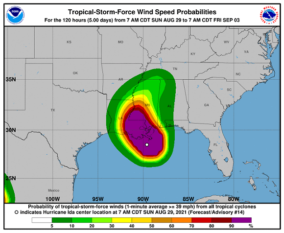
The current path of the storm is expected to bring Hurricane Ida onshore southwest of New Orleans, the National Hurricane Center (NHC) reports. Maximum sustained winds are currently at 150 miles per hour.
The well-organized eye of Ida is located just off the southern coast of Louisiana and appears to be tracking toward Houma and Thibodaux. This places the city of New Orleans directly on the “dirty side” of the storm where the highest rainfall totals could occur.
The storm moves into the area during the anniversary of 2005’s deadly Hurricane Katrina that left approximately 1,800 people dead and caused $125 billion in damages. The track of Katrina placed New Orleans on the storm’s western, or clean side. However, the storm surge and inland rains causing flooding led to the collapse of the levees and deadly flooding.
National Hurricane Center
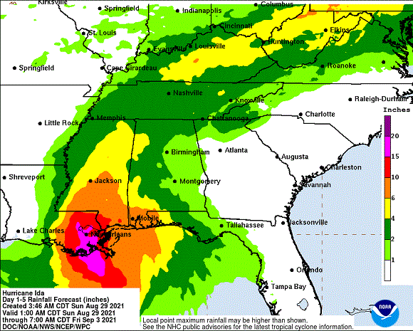
Over the next few days, Ida is predicted to dump more than 15 inches of rain on southern Louisiana, the NHC predicts. Some areas could receive up to 24 inches of rain. The storm will slowly move inland and continue to dump heavy along the tributaries that dump into the Mississippi River.
National Hurricane Center
“Ida is an extremely dangerous category 4 hurricane on the Saffir-Simpson Hurricane Wind Scale,” the NHC reports. “Some slight additional strengthening is still possible before Ida moves onshore along the Louisiana coast. Rapid weakening is expected after landfall.”
National Hurricane Center
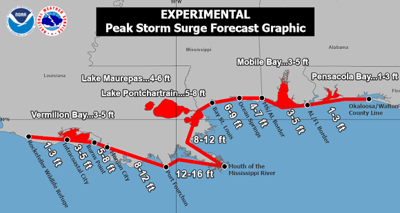
Officials predict a possible storm surge of up to 16 feet at the mouth of the Mississippi River. “Overtopping of local levees outside of the Hurricane and Storm Damage Risk Reduction System is possible where local inundation values may be higher than those shown above,” the latest storm briefing from the NHC reports.
“The deepest water will occur along the immediate coast near and to the east of the landfall location, where the surge will be
accompanied by large and dangerous waves,” the report continues. “Surge-related flooding depends on the relative timing of the surge and the tidal cycle, and can vary greatly over short distances.”
“This is going to be a very difficult storm,” Louisiana Governor John Bell Edwards told CBS News on Sunday. “It’s going to come in with sustained winds of over 150 miles per hour…there’s virtually no difference between a very, very strong Cat 4 storm and a Cat 5 storm.”
Bob Price serves as associate editor and senior news contributor for the Breitbart Texas-Border team. He is an original member of the Breitbart Texas team. Price is a regular panelist on Fox 26 Houston’s What’s Your Point? Sunday-morning talk show. Follow him on Twitter @BobPriceBBTX and Face
COMMENTS
Please let us know if you're having issues with commenting.