

The U.S. recently strengthened its military presence in the Arctic due to a heavy Chinese and Russian presence. Sources told CNN that American officials witnessed a Russian intelligence vessel in the Arctic near a Shell Oil ship on Monday.
However, it is no surprise that Russia continues to build their military in the Arctic. In September 2014, Russian President Vladimir Putin announced that Russia’s military presence in the Arctic is one of nation’s top priorities, arguing that it will protect shipping routes between Europe and the Pacific.
America’s addition is made up between 16 intelligence agencies. From the L.A. Times:
Over the last 14 months, most of the 16 U.S. intelligence agencies have assigned analysts to work full time on the Arctic. The Office of the Director of National Intelligence recently convened a “strategy board” to bring the analysts together to share their findings.
In addition to relying on U.S. spy satellites orbiting overhead and Navy sensors deep in the frigid waters, the analysts process raw intelligence from a recently overhauled Canadian listening post near the North Pole and a Norwegian surveillance ship called the Marjata, which is now being upgraded at a U.S. Navy shipyard in southern Virginia.
The Pentagon confirmed that the military tracked at least “five Chinese warships in the Bering Sea, between Alaska and Russia, for the first time.” The Pentagon also told CNN that officials witnessed a Russian intelligence ship in the same area near a ship operated by Shell Oil.
“We are aware of the Russian vessel Kurily sailing in the vicinity of the Nobel Discoverer,” Pentagon spokesman Jeff Davis explained to CNN. “We recognize the rights of all sovereign nations to freely navigate in international waters.”
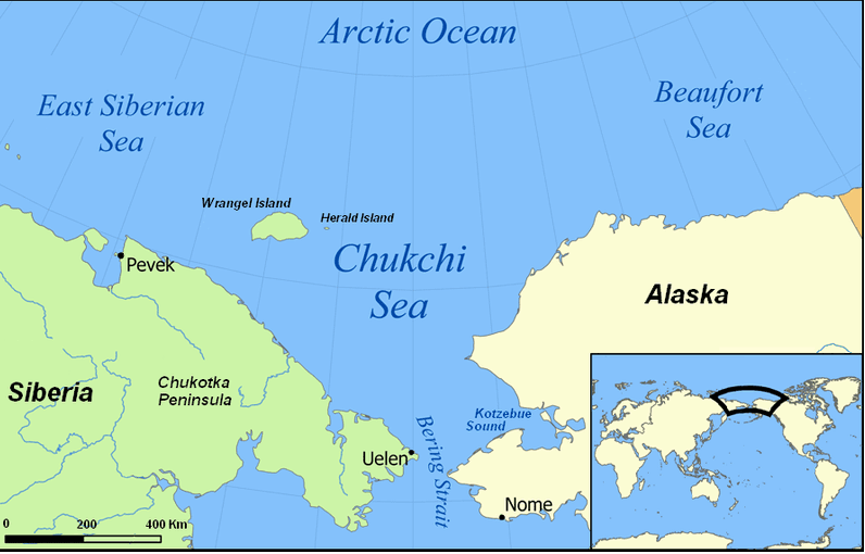
Shell contracted the ship “that is exploring for oil in the Chukchi Sea, which is north of the Bering Strait and lies between Alaska and Russia.” The National Geospatial-Intelligence Agency (NGA) drew “new maps and charts of waterways and territories” the past two years:
Some of the transformation is visible on detailed digital maps that the NGA made public last week, while President Obama was on a three-day visit to Alaska and became the first U.S. president to visit a community above the Arctic Circle.
The maps show airstrips, oil drilling areas, ports, maritime boundaries and sea routes. The NGA plans to make public 3D maps of all of Alaska by 2016 and the entire Arctic by 2017 to help track melting sea ice and receding glaciers.
Some Russian spy ships have passed near the Georgia coastline this year on their way to Cuba. The Viktor Leonov CCB-175 arrived in Havana, Cuba, a day before U.S.-Cuba talks. Cuba did not announce the arrival, but U.S. officials “played down” the existence of the ship since it is “legal and not at all out of the ordinary.”
The U.S. military spotted that same ship along with the Nikolay Chiker off the coast of Kings Bay in April. The ships hold 200 soldiers with high-tech electronic surveillance equipment and weaponry, AK-630 rapid-fire cannons, and surface-to-air missiles.”
An unidentified Russian ship sailed near Kings Bay last week. The sophisticated ship can cut “undersea cables and other sensors.” The U.S. has been monitoring the ship since satellites caught it on radar last month.
COMMENTS
Please let us know if you're having issues with commenting.