
Despite the growing break in the Oroville Dam spillway, there are no evacuation plans downstream along the Feather River for Sutter County or Sacramento Counties at this time.
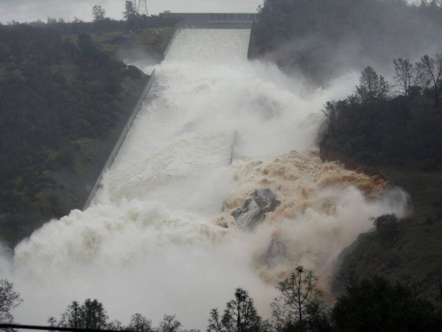
Breitbart News noted on February 9 that with water flowing into Oroville Dam at a rate of 83,000 cubic feet per second (cfs), that the dam’s spillway suffered a 200-foot-long, 30-foot-deep hole when officials tried to discharge 55,000 cfs. Massive amounts of water and chunks of concrete surged down the Feather River, causing numerous downstream mudslides and washouts.
The California Department of Water Resources (DWR) and collaborating agencies announced that the spillway had suffered additional lower level erosion, despite the agency successfully slowing the water surge from 55,000 to 20,000 cubic feet per second (cfs) during the day.
Engineers closed the spillway on the morning of February 10 to evaluate the integrity of the structure. Their conclusion is that there is no threat to the integrity of Oroville Dam or risk to public safety at this time. After conferring with state and federal dam safety entities and acknowledging there will be more erosion, the DWR began ramping the controlled spillway flow back up to 35,000 cfs.
The 3.5 million acre-feet capacity Oroville Dam is an earthen embankment that, at 770 feet in height, is the tallest dam in the United States, and creates the second largest man-made lake in the State of California. The project took 155 million tons of materials to complete in 1966.
The current water level on Oroville Lake is 96 percent of capacity, and about 50 percent higher than its historical average. The dam came close to being overtopped in 1964, as it filled at a rate of 250,000 cfs, and in 1997, when it filled at a rate of 331,000 cfs. In both cases, engineers were able to limit the downstream flow to 157,000 cfs and spare large regions of the Sacramento Valley from flooding.
Federal Energy Regulatory Commission’s Dam Safety Branch and the DWR Division of Safety of Dams are jointly providing on-site engineers, drones and webcams to monitor the deteriorating cement spillway chute.
As a contingency, the DWR is preparing to use an ungated concrete crest spillway for the first time in its 48-year history if the reservoir water level reaches an elevation of 901 feet. The reservoir came within one foot of flowing over the emergency spillway in January 1997. Lake Oroville currently holds approximately 3.22 million acre-feet of water and stands at an elevation of 880 feet, or 96 percent of capacity. CAL FIRE crews have been mobilized for an emergency clearing of approximately 100 acres of trees and brush that could be affected if water flows over the dam crest.
Water topping the Oroville Dam may cause severe property damage, and it would be catastrophic for downstream salmon and steelhead populations. With the Feather River Hatchery at risk of being inundated by a large load of sediment and turbidity, DWR Crews are placing debris booms in several key areas in its Diversion Pool to protect the young hatchlings and eggs.
California Republicans and Central Valley Democrats have pushed for new flood control reservoirs, but environmental restrictions have prevented building a large state- or federally-funded reservoir built in 38 years.
The U.S. Bureau of Reclamation offered $1.1 billion to raise the height of Shasta Dam by 18.5 feet to increase water storage by 14 percent, but the Obama administration killed the project in 2014 by filing a 349-page report claiming any expansion would threated salmon under the Endangered Species Act.
COMMENTS
Please let us know if you're having issues with commenting.