
Millions of Americans are bracing for what the National Weather Service (NWS) has described as a “significant ice storm,” expected to sweep the south this week.
Forecast maps show the bad weather spanning from Texas to West Virginia.
“Prolonged and potentially significant icing event to impact a large area from the southern Plains to the Tennessee Valley,” the latest update from the NWS reads.
“The headlining weather story over the next several days will be the long-duration ice storm across portions of the Southern Plains and Mid-South that is ongoing and forecast to continue into Wednesday,” it continues, warning of coming conditions for freezing rain and sleet:
NWS continues:
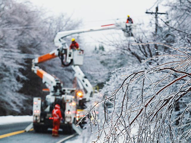
Furthermore, multiple rounds of wintry precipitation are forecast, with light freezing rain and sleet expected through Monday evening and continuing on and off through at least Wednesday. Widespread ice accumulations of greater than a quarter of an inch are likely, with localized areas receiving as much as half an inch. In addition to potentially hazardous travel conditions, this amount of ice will lead to tree damage and power outages across the hardest-hit regions. Sleet accumulations up to a half inch are also possible along the far northern sections of the precipitation shield from northern Texas to northern Arkansas, which can also lead to treacherous travel or add to the already slippery conditions.
Several areas of the country are under various ice storm warnings and winter storm warnings. Further, NWS also predicts temperatures 20-30 degrees below average “throughout much of the Plains and Intermountain West.”
According to reports, roughly 40 million people are under some type of watch, warning, or advisory related to the coming winter weather.
The latest storm comes over a month after the winter storm battering a large swath U.S. prior to Christmas, as the arctic blast had over 200 million Americans under some type of winter storm warning, watch, or advisory. That particular storm saw temperatures nosediving across the country, dropping by the double digits in less than an hour in areas such as Cheyenne, Wyoming, and Denver, Colorado.
COMMENTS
Please let us know if you're having issues with commenting.