
After the recent Bundy Ranch episode by the U.S. Bureau of Land Management (BLM), Texans are becoming more concerned about the BLM’s focus on 90,000 acres along a 116 mile stretch of the Texas/Oklahoma boundary. The BLM is reviewing the possible federal takeover and ownership of privately-held lands which have been deeded property for generations of Texas landowners.
Sid Miller, former Texas State Representative and Republican candidate for Texas Agriculture Commissioner, has since made the matter a campaign issue to Breitbart Texas.
“In Texas,” Miller says, “the BLM is attempting a repeat of an action taken over 30 years ago along the Red River when Tommy Henderson lost a federal lawsuit. The Bureau of Land Management took 140 acres of his property and didn’t pay him one cent.”
Miller referred to a 1986 case where the BLM attempted to seize some of Henderson’s land. Henderson sued the BLM and lost 140 acres that had been in his family for generations. Now the BLM is looking at using the prior case as a precedent to claim an additional 90,000 acres.
Congressman Mac Thornberry (R-TX) represents the ranchers in this region of north Texas. According to Thornberry’s legislative analysts, the issue of the ownership of this land dates back to the Louisiana Purchase of 1803. When the BLM made the claim on Henderson’s land, their position was that Texas never had the authority to deed the land to private parties and therefore it would fall under federal control.
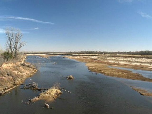
In 1922, the U.S. Supreme Court attempted to settle the boundary dispute in Oklahoma v. Texas and declared the boundary to be defined by wooden stakes set on the river bank. That boundary apparently lasted no longer than anyone could expect wooden stakes to last in the shifting sands of a meandering river. In 2000, Texas and Oklahoma’s legislatures agreed to a “Red River Boundary Compact” which defined the border between the states as the southern vegetation line. However, Congress must ratify agreements of this kind between the states according to Article 1, Section 10 (Clause 3) of the U.S. Constitution. Congressman Thornberry introduced House Joint Resolution 72 during the 106th Congress to codify the compact into U.S. Law.
The matter became somewhat of a national question drawing the attention of Vermont Senator Bernie Sanders, “The U.S. Supreme Court has tried twice to settle this dispute, which at one point brought the governor of Oklahoma to the border in a tank…However, true to the slogan ‘One Riot, One Ranger,’ the good governor of Oklahoma and his tank was held off by a lone Texas Ranger on his horse.”
Tanks aside, the Texas Farm Bureau has produced a video that explains the problems left open by the current border definition from north Texas ranchers’ perspectives. This issue reportedly centers on Oklahoma’s definitions on the various forms of movement with the river.
The Texas Farm Bureau asserts the State of Oklahoma believes that whenever the river shifts south, the state line moves south. But when the river moves north, the line remains in place. Now, the BLM seems to want to settle the matter by simply confiscating the land.
According to a BLM document provided to Breitbart Texas courtesy Rep. Thornberry’s staff, the BLM is going through a scoping period where they are gathering facts on land whose ownership they believe to be in question in Texas, Oklahoma and Kansas. The BLM is in the process of developing a Resource Management Plan. The plan will cover a total of 411,585 square miles, or 263 million acres of land. The BLM describes its “decision area as about 104,000 acres of BLM administered surface lands, 593,000 acres of split-estate land (private land with federal mineral interests) and 5,270,000 acres of federal mineral interests on land managed by other federal agencies.”
COMMENTS
Please let us know if you're having issues with commenting.