

TALLAHASSEE, Florida — From Key West to Pensacola, Florida’s 20.6 million residents are likely to feel the impact of Hurricane Irma as the storm hits the state.
**UPDATES BELOW**
UPDATE 9 a.m. ET: Naples Daily News: Irma aid could help illegal immigrants according to Gov. Rick Scott.
Naples Daily News’ Maria Perez has the story.
After Hurricane Irma ripped up homes, damaged businesses and flooded roads throughout Southwest Florida, Gov. Rick Scott said Monday that he was going to help all Floridians.
And that could include undocumented immigrants.
“My goal is everybody in our state, we are doing anything we can to take care of them,” said Scott when asked whether assistance would be provided to undocumented immigrants.
(h/t Politico Florida)
UPDATE 8:45 a.m. ET: Curfew lifted in Leon County, FL, location of the state capitol.
UPDATE 8 a.m. ET: Flight have resumed at Tampa International Airport
UPDATE 6 a.m. ET Tuesday: Irma now a post-tropical cyclone. NWS issues final advisory.
The storm located at 33.0°N 85.2°W, moving north at 16 mph, 100 miles east of Birmingham.
Final tallies are offered as follows:
...SELECTED PRELIMINARY STORM TOTAL RAINFALL IN INCHES THROUGH 5
AM EDT

...ALABAMA...
EUFAULA MUNI ARPT                     3.25
DOTHAN RGNL ARPT                      2.76
MONTGOMERY                            2.15

...FLORIDA...
FT. PIERCE ST. LUCIE CNTY INTL ARP   15.91
OVIEDO                               14.76
CHEKIKA                              13.83
INLIKITA 7 WNW                       13.63
GAINESVILLE 2.4 NW                   12.22
MIMS 8.5 W                           12.11
NAPLES                               11.87
NATIONAL KEY DEER NWR                11.74
OVIEDO 1.6 SE                        11.54
CACHE                                11.49
STARKE                               11.33
WEST MELBOURNE                       11.21
JACKSONVILLE 9.6 SE                  11.17
FLEMING ISLAND 2.2 S                 11.11
SWITZERLAND 4 WSW                    11.11
PANTHER WEST                         11.08
ORTEGA 1 WNW                         11.00
UNIVERSITY OF FLORIDA 3 NW           10.42
FORT MYERS INTL ARPT                 10.33
SUMMERFIELD 3 SSE                    10.04
OASIS RANGER STATION                  9.67
OKEECHOBEE COUNTY ARPT                9.65
FORT LAUDERDALE EXEC ARPT             9.57
ORLANDO/SANFORD ARPT                  9.42
OCHOPEE                               9.27
OLUSTEE 3 N                           9.17
ALACHUA 5 SE                          8.61
MILES CITY                            8.26
BELLAIR 3 W                           8.11
OPA-LOCKA AIRPORT                     7.99
ORLANDO EXECUTIVE ARPT                7.68
FORT WHITE 4 SE                       7.57
INTERLACHEN 4 NW                      6.22
TALLYRAND 2 NNW                       6.15
DAYTONA BEACH INTL ARPT               5.86
HOLLYWOOD 3.9 SW                      4.68
PALM CITY 3.1 NW                      4.58
FLEMING ISLAND 1.7 SE                 4.56
MIAMI BEACH                           3.95
VERO BEACH 2.5 S                      3.25

...GEORGIA...
ST MARYS RIVER NEAR KINGSLAND 5SSE   10.12
CUMBERLAND SOUND NEAR ST MARYS 5ENE   9.18
HOMELAND                              7.99
THALMANN 5 ESE                        7.89
BOYS ESTATE 3 S                       7.84
FOLKSTON 10 SW                        7.80
SAVANNAH/HUNTER AAF                   6.88
KINGSLAND 3 WSW                       6.85
ATKINSON 1 WSW                        6.66
BRUNSWICK, MALCOLM MCKINNON ARPT      6.32
SAPELO ISLAND 1 NW                    5.97

...SOUTH CAROLINA...
EDISTO ISLAND 2 WNW                   6.05
BLACKVILLE 2 W                        6.01
BEAUFORT MCAS                         5.88
SANTEE 5 NNE                          5.74
FOLLY FIELD 1 SW                      5.67
CHARLESTON INTL ARPT                  5.53
EASTOVER 6 SW                         4.97
NEW ELLENTON 4 S                      4.81
EDGEFIELD                             4.12
SUMTER                                4.11
COLUMBIA METRO AIRPORT                3.14

...SELECTED PEAK WIND GUSTS IN MILES PER HOUR EARLIER IN THE
EVENT...

...ALABAMA...
TROY MUNICIPAL AIRPORT                45
WEEDON FIELD AIRPORT                  43
ANNISTON ARPT ASOS                    40
MONTGOMERY REGIONAL AIRPORT           40

...FLORIDA...
NAPLES 2 ENE                         142
MARCO ISLAND 1 E                     130
LELY 2 ESE                           122
BIG PINE KEY 2 NNW                   120
QUAIL CREEK ESTATES 2 SSW            112
NORTH PERRY AIRPO 2 WNW              109
KEY BISCAYNE 8 SSE                    99
MIAMI INTERNATIONAL 1 W               99
NORTH PERRY AIRPO 3 WSW               98
SWEETWATER 2 NE                       96
CAPE CANAVERAL 3 NNE                  94
OCEAN REEF 8 SE                       93
BELLE MEADE 1 S                       92
KEY LARGO 8 SSE                       92
OCHOPEE 1 W                           92
CACHE AT EVERGLADES                   91
KEY WEST 2 W                          91
ROYAL PALM RANGER S 4 W               91
CORAL GABLES 1 ESE                    90
OCEAN REEF 8 SSE                      89
SOUTHWEST FLORIDA INTL ARPT           89
MAYPORT NAVAL STATION                 87
PORT EVERGLADES                       87
DEERFIELD BEACH 3 W                   86
JACKSONVILLE INTL ARPT                86
KEY LARGO 1 SE                        85
REDLAND 8 NNW                         85
FORT MYERS FAA/AP                     84
SUNRISE 1 W                           84
FLAGLER BEACH                         83
GOULDS 1 NE                           83
HOMESTEAD PARK 1 WSW                  83
OAKLAND PARK 3 NW                     83
PINECREST 2 SSW                       82
FIU SOUTH CAMPUS                      81
HAULOVER CANAL 3 E                    81
POMPANO BEACH AIR 1 ESE               81
RSW SOUTHWEST FLORIDA A               81
IMMOKALEE 2 ESE                       80
SOUTH MIAMI 2 W                       80
FISHER ISLAND 3 ESE                   79
FIU NORTH CAMPUS 1 ESE                79
FORT DESOTO PARK 3 W                  79
FLORIDA CITY 1 ESE                    78
FORT LAUDERDALE 2 W                   78
NORTH PERRY AIRPORT                   78
SANIBEL 4 ENE                         78
SUNRISE 2 E                           78
CLEARWATER 4 WNW                      77
PARKLAND 2 W                          77
WEST MIAMI 2 SE                       77
BARTOW 10 SSW                         75
DAVIE 2 NE                            75
DELRAY BEACH 3 WSW                    75
SAINT AUGUSTINE 1 NW                  75
LITTLE HAITI 2 SE                     74
BUNNELL                               72
COUNTRY WALK 1 N                      72
HOLIDAY 4 SW                          70
INDIAN LAKE ESTATES 2 S               70
LITTLE HAVANA 1 NNW                   68
LAUDERDALE BY THE 2 NW                67
PORT EVERGLADES 1 SSE                 66
DOWNTOWN SAINT PETE 4 E               65
SANFORD AIRPORT                       65
CORAL SPRINGS 1 W                     64
DELAND                                63
DANIA BEACH 1 NW                      62
ST. AUGUSTINE 6 NNW                   62
CROSS CITY AIRPORT                    61
HIALEAH GARDENS 1 E                   61
POMPANO BEACH                         61

...GEORGIA...
FORT PULASKI                          70
FORT SCREVEN                          70
TYBEE ISLAND 1 NNE                    65
HARTSFIELD ATLANTA INTL ARPT          64
MIDDLE GEORGIA REGIONAL ARPT          61
SAVANNAH AIRPORT                      60
TALLAPOOSA 4 SSE                      59
HABERSHAM COUNTY AP                   58
VALDOSTA 2 WNW                        58
CLEVELAND                             57
LITTLE OCMULGEE STATE PARK            57
DUBLIN                                54
PERRY                                 54
COLUMBUS AIRPORT ASOS                 53
VIDALIA                               53
ATHENS 3 ESE                          52
BANKS CROSSING                        51
JASPER 2 SSW                          48
TUCKER 2 SE                           47
MOODY AFB                             44

...NORTH CAROLINA...
HIGHLANDS 2 NNW                       56
CASHIERS 1 ESE                        51
BOOMER 3 ESE                          47
BELMONT                               45
CHARLOTTE DOUGLAS INTL ARPT           45

...SOUTH CAROLINA...
PARRIS ISLAND 6 E                     76
FOLLY BEACH                           72
ISLE OF PALMS 1 ESE                   68
SULLIVANS ISLAND 1 E                  68
BATTERY POINT 1 NNW                   66
BEAUFORT                              66
CHARLESTON 2 SSW                      66
DANIEL FIELD AIRPORT                  58
OCONEE COUNTY REGION                  58
AUGUSTA BUSH FIELD                    55
LANCASTER COUNTY AIRPORT              55

...TENNESSEE...
GATLINBURG 10 S                       60
CHATTANOOGA 4 ESE                     45
UPDATE 11:35 p.m. ET: Tim Tebow appears with Gov. Rick Scott at a shelter in Jacksonville.
The Florida Times-Union has the story.
UPDATE 11:30 p.m. ET: Miami Beach Mayor Philip Levine to Fox News: Miami Beach will be open for business tomorrow
UPDATE 11:15 p.m. ET: Sporadic outages from Irma in Alabama
UPDATE 11:00 p.m. ET: Irma downgraded to a tropical depression.
The National Hurricane Center’s latest advisory has the storm located at 32.4°N 84.9°W, moving north at 16 mph, 5 miles south of Columbus.

UPDATE 8:45 p.m. ET: Reentry into the Florida Keys set to begin tomorrow
UPDATE 8:30 p.m. ET: Gov. Rick Scott assures Florida residents fuel is on the way
UPDATE 8:20 p.m. ET: The Associated Press has video of Irma’s path of destruction in Key Largo.
UPDATE 8:00 p.m. ET: Irma continues to weaken.
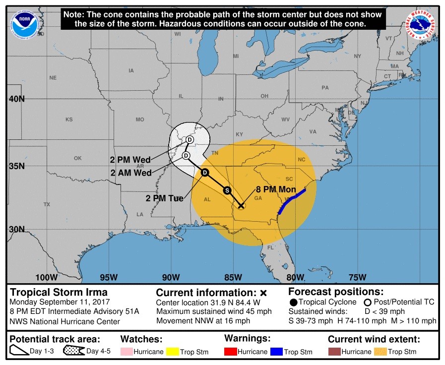
The National Hurricane Center’s latest advisory has the storm located at 31.9°N 84.4°W, moving north at 16 mph, 55 miles east of Columbus.
UPDATE 6:00 p.m. ET: Politico’s Matt Dixon reports Hurricane Irma could cost $92 billion in “economic damages” according to Moody’s.
UPDATE 5:35 p.m. ET: Pockets of congestion on Interstates 4, 10, 75 and 95 headed back into various locations in Florida
Report from the Miami Herald’s Kristen Clark
UPDATE 5:25 p.m. ET: Tropical Storm Irma now in Georgia
The National Hurricane Center’s latest advisory has the storm located at 31.5°N 84.0°W, moving north at 17 mph, 10 miles east of Albany.

UPDATE 5:15 p.m. ET: The Florida Times-Union’s Nate Monroe on Jacksonville’s hit by Irma: The winds subsided and the rain stopped. Then the emergency began.
By Monday afternoon, Hurricane Irma had largely finished with Jacksonville. Mother Nature, however, had not.
A cocktail of severe natural forces converged in ways that turned Monday into a slow-motion disaster for downtown, Riverside, San Marco and in other neighborhoods throughout the city that sit along the St. Johns River and the maze of waterways that feed into it.
(h/t Peter Schorsch)
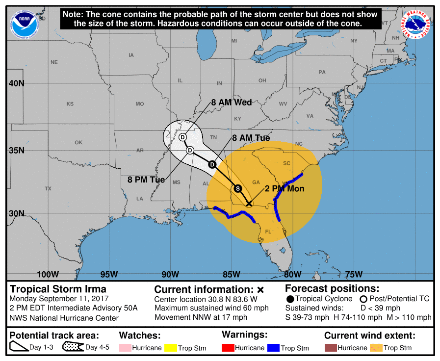
UPDATE 2:30 p.m. ET: The National Hurricane Center’s latest advisory has the storm located at 30.8°N 83.6°W, moving north at 17 mph, 85 miles east of Tallahassee.
UPDATE 2:15 p.m. ET: Former Univeristy of Florida quarterback and minor league baseball player Tim Tebow added to Gov. Rick Scott’s schedule for meeting about Irma.
UPDATE 1:30 p.m. ET: Images from Jacksonville in northern Florida are coming in. Despite a weaker storm, areas of the city’s downtown have flooded.
UPDATE 1 p.m. ET: As the storm is making its way out of Florida and into Georgia, still over the half the state is without power.
UPDATE 11:45 a.m. ET: A1A in Ft. Lauderdale Beach covered in sand post-Irma.
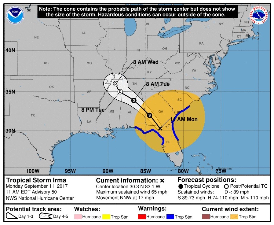
UPDATE 11:30 a.m. ET: The National Hurricane Center’s latest advisory has the storm located at 30.3°N 83.1°W, moving north at 17 mph, 70 miles east of Tallahassee.
UPDATE 10 a.m. ET: 6.2 million without power in Florida
UPDATE 9:15 a.m. ET: Tampa Mayor Bob Buckhorn decries climate change in wake of Irma
UPDATE 8:05 a.m. ET: Irma downgraded to a tropical storm.
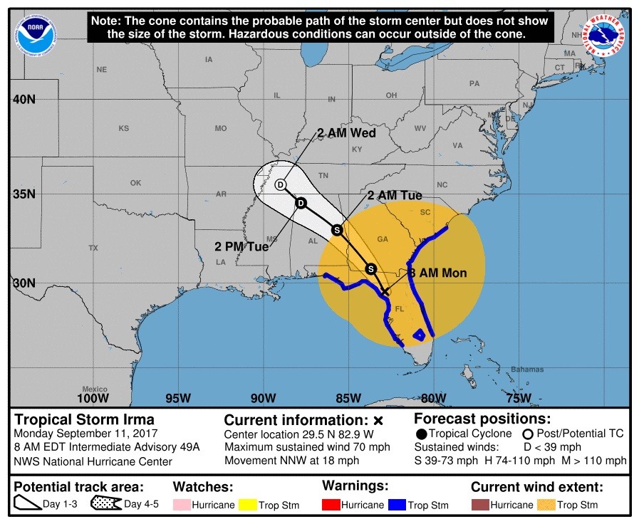
The National Hurricane Center’s latest advisory has the storm located at 29.5°N 82.9°W, moving north at 18 mph, 105 miles north of Tampa.
UPDATE 8 a.m. ET: Politico’s Marc Caputo reports Gov. Rick Scott will fly over the Florida Keys in a Coast Guard aircraft to make an assessment and possible delivery of emergency supplied.
UPDATE 7:30 a.m. ET: Record flooding in Jacksonville, FL on the east side of the storm.
UPDATE 7:15 a.m. ET: 4.6 million without power in Florida and Georgia according to the Associated Press.
UPDATE 7 a.m. ET: Tampa Mayor Bob Buckhorn breathes a “sigh of relief.”
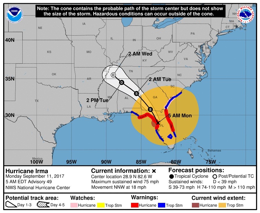
UPDATE 6:30 a.m. ET: Irma downgraded to a Category 1
The National Hurricane Center’s latest advisory has the storm located at 28.9°N 82.6°W, moving north at 18 mph, 100 miles north of Tampa.
UPDATE 12:45 a.m. ET: Tampa Bay Times Monday edition will be an e-edition only issue.
UPDATE 12:15 a.m. ET Monday: Polk County, FL Sheriff Grady Judd sued.
From the Orlando Sentinel’s Krista Torralva and Steven Lemongello:
A man who claims he was denied entry to a shelter unless he underwent a background check is suing Polk County Sheriff Grady Judd, who got national attention after saying on Twitter he would jail anyone with an outstanding warrant who tried to seek shelter from Hurricane Irma.
Judd called the lawsuit “frivolous” and said he would not change his policy.
UPDATE 11:35 p.m. ET: Miami Police Department offers a warning for any would-be looters
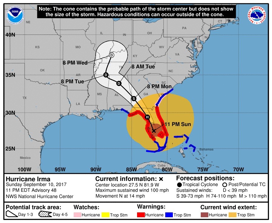
UPDATE 11:05 p.m. ET: The National Hurricane Center’s latest advisory has the storm located at 27.5°N 81.9°W, moving north at 14 mph, 50 miles south of Tampa.
UPDATE 11 p.m. ET: From Breitbart’s Trent Baker — CNN’s Bill Weir: Hurricane Irma Damage ‘Unlike Anything I’ve Seen in 25 Years’
“If this is a sample of what we’re going to find in Key West, the southern paradise of the United States as we know it has fundamentally changed,” said Weir.
UPDATE 10:55 p.m. ET: Miami Beach closed to cars until Tuesday at noon.
UPDATE 9 p.m. ET: Hemingway House curator tells MSNBC’s Ali Irma left the house intact and the house’s 54 six-toed cats are safe.
Watch:
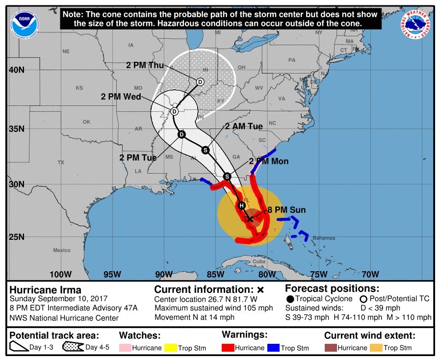
UPDATE 8:15 p.m. ET: The National Hurricane Center’s latest advisory has the storm located at 26.7°N 81.7°W, moving north at 14 mph, 15 miles north of Fort Myers.
UPDATE 7:30 p.m. ET: Watch — Drone footage of Irma’s aftermath in Naples
UPDATE 6:45 p.m. ET: Curfews are being established all across Florida as Hurricane Irma arrive
UPDATE 6:33 p.m. ET: Still going strong in Miami.
https://twitter.com/DanNBC6/status/907008486453768192
UPDATE 6:29 p.m. ET: Animals acting chill.
UPDATE 6:20 p.m. ET: The storm is now approaching Fort Meyers.
UPDATE 6:18 p.m. ET: NHC reports that water levels in Naples, FL have risen seven feet in the last 90 minutes.
UPDATE 6:13 p.m. ET: More scenes from Florida:
UPDATE 5:20 p.m. ET: Irma downgraded to a Category 2
The National Hurricane Center’s latest advisory has the storm located at 26.2°N 81.8°W, moving west at 14 mph, 5 miles north of Naples.
UPDATE 4:45 p.m. ET: 120 mph+ gusts recorded in Naples.
UPDATE 3:53 p.m. ET: Naples braces for a direct hit.
UPDATE 3:48 p.m. ET: Looters caught on video now caught by law enforcement:
UPDATE 3:38 p.m. ET: Irma hits Marco Island, outside Naples:
UPDATE 3:23 p.m. ET: More views from Miami:
UPDATE 2:30 p.m. ET: Tornado warnings issued for multiple locations in South Florida
UPDATE 2:15 p.m. ET: Looters caught on camera by WPLG in Ft. Lauderdale, FL
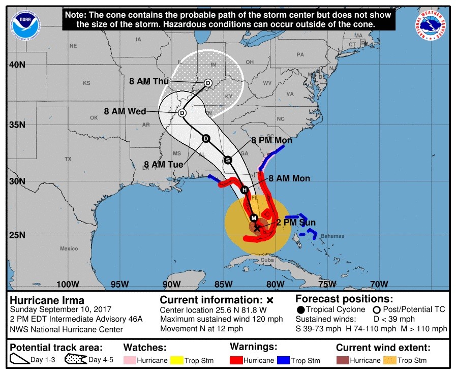
UPDATE 2:05 p.m. ET: Irma downgraded to a Category 3
The National Hurricane Center’s latest advisory has the storm located at 25.6°N 81.8°W, moving west at 12 mph, 35 miles south of Naples.
UPDATE 2 p.m. ET: Gov. Rick Scott has requested a major disaster declaration per reports.
UPDATE 1:30 p.m. ET: Tampa Mayor Bob Buckhorn: “Our day has come”
From Tampa Bay Business Journal senior reporter Ashley Gurbal:
As Hurricane Irma barreled toward the Tampa Bay region Sunday, officials issued grave warnings about the storm’s potential for destruction.
“I think our day has come,” Tampa Mayor Bob Buckhorn said at a news conference. “We have trained for this; we are ready for this. I will tell you in no uncertain terms — and I’m not going to sugar coat it — this is going to be a difficult storm.”
UPDATE 1:15 p.m. ET: Everglades City, FL’s Kent Daniels has images of Hurricane Irma’s arrival to southwest Florida.
UPDATE 1 p.m. ET: 1.5 million without power in Florida…
UPDATE 12:45 p.m. ET: Uber has suspended operations in Orlando, Tampa and Sarasota.
https://twitter.com/Uber_Florida/status/906914897228910593
UPDATE 12:40 p.m. ET: Florida AG Pam Bondi reports two law enforcement officers killed from Hurricane Irma.
UPDATE 12:25 p.m. ET: Additional National Guard troops are en route to Florida from other states.
UPDATE 12 p.m. ET: Water is being sucked out of Tampa Bay as Irma is on its way.
UPDATE 11:40 a.m. ET: Downtown Miami flooded with ocean water
UPDATE 11:30 a.m. ET: Construction crane collapses in downtown Miami.
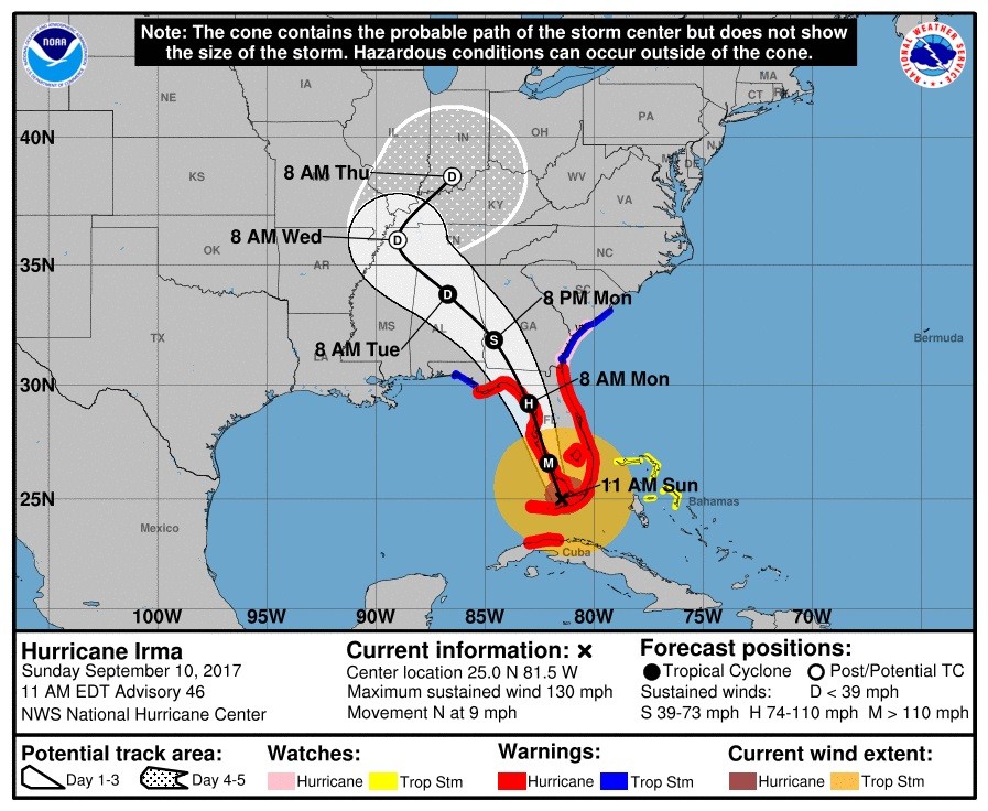
UPDATE 11 a.m. ET: The National Hurricane Center’s latest advisory has the storm located at 25.0°N 81.5°W, moving west at 9 mph, 80 miles south of Naples.
UPDATE 10:45 a.m. ET: The Miami Herald’s Joey Flechas has video of strong winds and rising water in the Brickell community of Miami
UPDATE 10:30 a.m. ET: The center of Hurricane Irma is now making its way to the Florida mainland.
UPDATE 10:20 a.m. ET: Wind gust of 120 mph detected on Big Pine Key
UPDATE 10 a.m. ET: The National Weather Service in Miami says a wind gust of 82 mph was recorded at the Miami International Airport.
UPDATE 9:30 a.m. ET: Naval Air Station Key West’s Twitter account has uploaded some breathtaking video of Irma’s arrival.
UPDATE 9:25 a.m. ET: Florida Today’s Isadora Rangel reports 100 mph+ wind gusts in the Keys.
UPDATE 9:15 a.m. ET: From FLKeysNews.com’s David Goodhue — City of Marathon: ‘Everything is under water, I mean everything’
UPDATE 8:55 a.m. ET: NBC News’ Gadi Schwartz has footage showing a half-impassable U.S. 1 in the Florida Keys.
UPDATE 8:45 a.m. ET: 381,000 in Florida now without power.
UPDATE 8:30 a.m. ET: The National Hurricane Center’s latest advisory has the storm located at 24.5°N 81.5°W, moving west at 8 mph, 20 miles southeast of Key West.

UPDATE 5:45 a.m. ET: New ECMWF 00z model has Hurricane Irma not making landfall on the Florida peninsula, but southeast of Tallahassee in the state’s Big Bend Region.
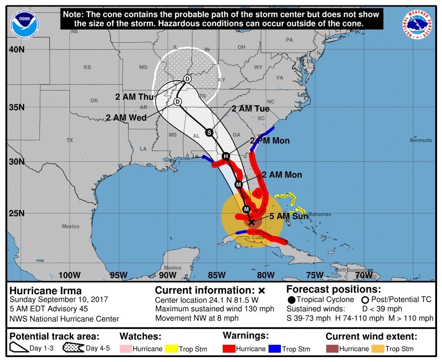
UPDATE 5:30 a.m. ET: The National Hurricane Center’s latest advisory has the storm located at 24.1°N 81.5°W, moving west at 8 mph, 40 miles southeast of Key West.
UPDATE 2:15 a.m. ET: Hurricane Irma a Category 4 storm once again
The National Hurricane Center’s latest advisory has the storm located at 23.7°N 81.3°W, moving west at 6 mph, 70 miles southeast of Key West.

UPDATE 1:35 a.m. ET: 79 mph wind gust recorded in Key West, FL.
UPDATE 1:30 a.m. ET: Former Gov. Mike Huckabee (R-AR), now a Florida resident, told Fox News late Saturday Gov. Rick Scott’s leadership in preparation for Hurricane Irma’s arrival has been “spectacular.”
UPDATE 1:20 a.m. ET: Pasco County, FL Sheriff’s Department is lobbying against gun owners discharging their firearms into the storm.
UPDATE 1:15 a.m. ET: From Breitbart’s Trent Baker — Tampa Mayor: ‘We’re About to Be Punched in the Face’
UPDATE 12:45 a.m. ET: Much of Florida south of the I-4 corridor is presently under a tornado watch until noon Sunday.
UPDATE 12:10 a.m. ET: Fort Lauderdale Mayor Jack Seiler: “We’ve had 2 tornadoes confirmed touch down.”
UPDATE 12 a.m. ET Sunday: CNN reports 65 percent of the Miami-Ft. Lauderdale market are out of gas.
Nearly 65% of all gas stations in the Miami-Fort Lauderdale market were without fuel on Saturday, according to estimates from crowdsourcing platform GasBuddy.
More than half of the stations in the West Palm Beach-Fort Pierce and Fort Myers-Naples areas have run dry. In the Tampa-St. Petersburg market, 43.5% of stations are out of gas.
UPDATE 11:55 p.m. ET: Accuweather’s Reed Timmer has video of Irma’s arrival from Duval Street in Key West.
UPDATE 11:10 p.m. ET: From Breitbart Texas’ Bob Price — Trump Stations 1,000 Marines off Florida Coast for Irma Relief Operations
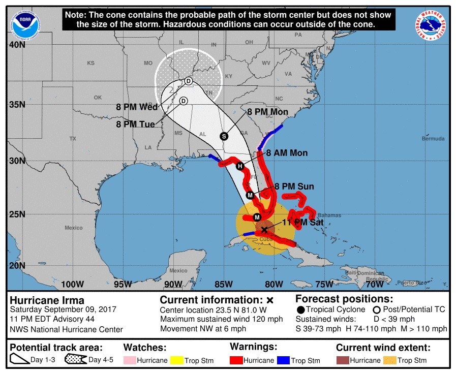
UPDATE 11:05 p.m. ET: The National Hurricane Center’s latest advisory has the storm located at 23.5°N 81.0°W, moving west at 6 mph, 90 miles southeast of Key West.
UPDATE 11 p.m. ET: Storm surge warnings are being canceled on Florida’s east coast and are being extended on its west coast.
UPDATE 10:50 p.m. ET: Miami-FSU game slated for Sept. 16 rescheduled. More here.
UPDATE 10:45 p.m. ET: Gov. Rick Scott offers a list of shelters opened throughout the state of Florida for evacuees.
UPDATE 10:20 p.m. ET: Hurricane force winds beginning to arrive in the Florida Keys per the National Hurricane Center.
UPDATE 10:10 p.m. ET: Alabama Gov. Kay Ivey (R) has activated her state’s National Guard ahead of Irma’s arrival in the Yellowhammer State.
UPDATE 10 p.m. ET: ABC News has footage of Irma’s destruction in U.S. Virgin Islands.
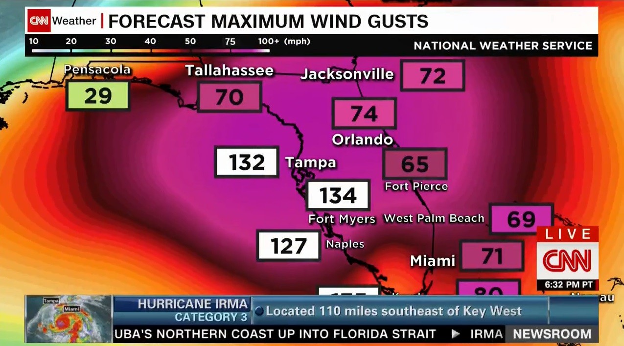
UPDATE 9:45 p.m. ET: Maximum wind gusts of 130 mph+ in Tampa and Fort Myers expected
UPDATE 9:35 p.m. ET: Per the Florida Department of Transportation, the Sunshine Skyway Bridge that connects St. Petersburg to Bradenton has closed in anticipation of Irma’s arrival and will remain closed until the storm has cleared.
UPDATE 9:30 p.m. ET: Alabama Couple Grills Hot Dogs to Feed Florida Evacuees — Breitbart’s Katherine Rodriguez has the story here.

UPDATE 9:25 p.m. ET: Watch: Drone footage of Florida Power and Light preparing to deploy in response to Hurricane Irma
UPDATE 9 p.m. ET: The National Hurricane Center’s latest advisory has the storm located at 23.3°N 80.8°W, moving west at 7 mph, 110 miles southeast of Key West.

UPDATE 8:45 p.m. ET: Irma now enters its 10th day as a hurricane, the longest run since 2008.
UPDATE 8 p.m. ET: Rainfall totals 15-20 inches throughout Florida forecasted
UPDATE 7:15 p.m. ET: Waterspout spotted off the shore in Ft. Lauderdale.
UPDATE 6:30 p.m. ET: Gov. Rick Scott (R-FL) says 70k already without power at a briefing in Tallahassee.
UPDATE 6 p.m. ET: Jacksonville Beach suspending alcohol sales “until further notice.”
https://twitter.com/DianneG/status/906639455234220033
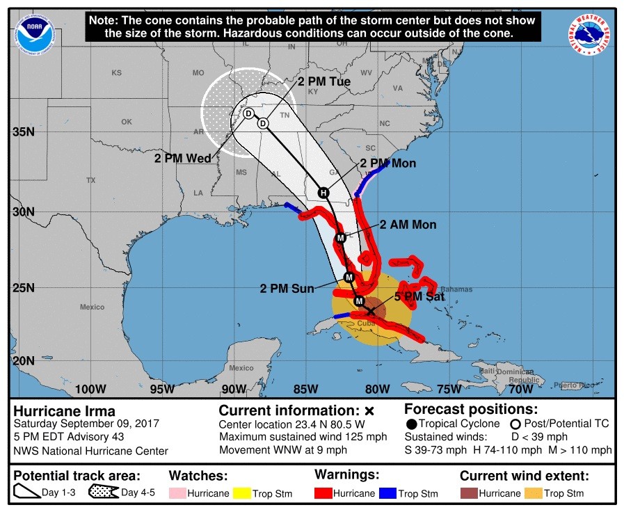
UPDATE 5:30 p.m. ET: The National Hurricane Center’s latest advisory has the storm located at 23.4°N 80.5°W, moving west at 9 mph, 115 miles southeast of Key West.
UPDATE 5 p.m. ET: Hurricane Irma is moving into the warm waters of the Straights of Florida, where it is expected to intensify.
UPDATE 4 p.m. ET: Tallahassee and Leon County, FL, presently 490 miles from Hurricane Irma, has issued a voluntary evacuation order.
City’s airport also shutting down at 5:40 p.m. local time on Sunday
UPDATE 3:45 p.m. ET: WTSP’s Caitlin McGehee reports not everyone heeded the warning to evacuate Key West ahead of Hurricane Irma
UPDATE 3:30 p.m. ET: Guantánamo Bay U.S. Naval Base “unscathed” from Hurricane Irma.
UPDATE 2 p.m. ET: The National Hurricane Center’s latest advisory has the storm located at 23.1°N 80.2°W, moving west at 9 mph, 145 miles southeast of Key West.

UPDATE 1:30 p.m. ET: Curfews issued for South Florida municipalities, per the Miami Herald.
UPDATE 12:30 p.m. ET: Irma downgraded to Category 3
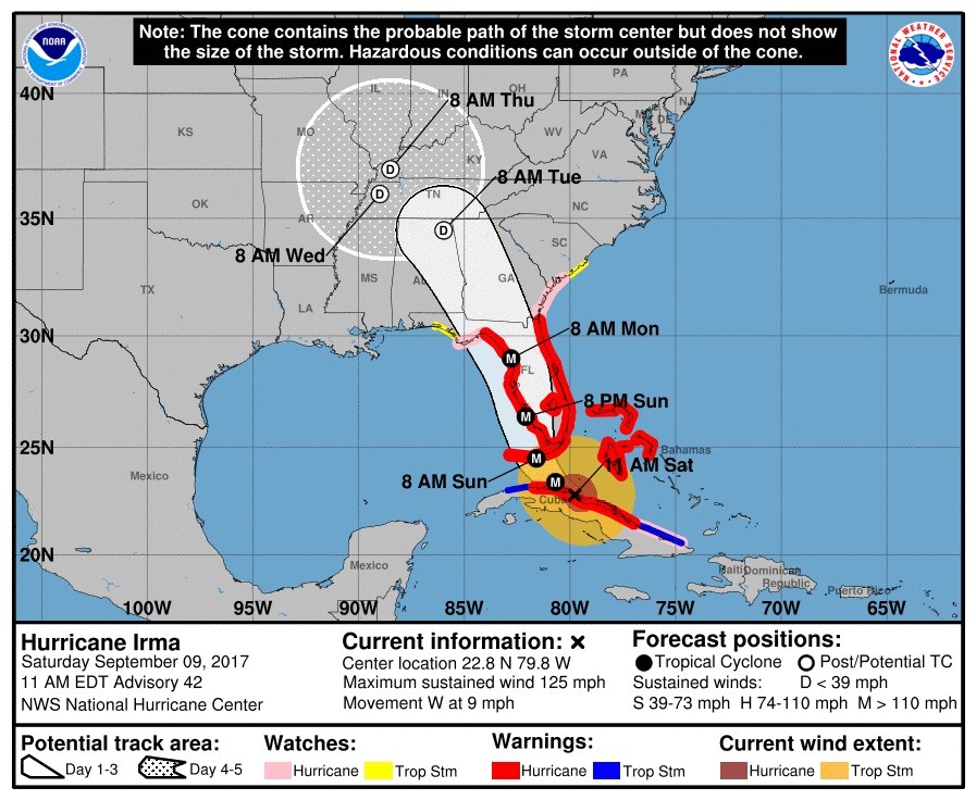
The National Hurricane Center’s latest advisory has the storm located at 22.8°N 79.8°W, moving west at 9 mph, 175 miles southeast of Key West.
UPDATE 12 p.m. ET: Another 700k asked to evacuate Florida per the Associated Press
UPDATE 10:30 a.m. ET: Computer models show Irma trekking up Florida’s west coast. However, the EURO and GFS show different predictions as the storm enters northern Florida.
UPDATE 9 a.m. ET: ‘LEAVE NOW,’ Florida Governor Tells 5.6 Million Residents in ‘Irma’s’ Path
Breitbart Texas’ Bob Price has the update here.
UPDATE 8:30 a.m.: Due to the numerous updates, a new live wire page has been started.
Updates are now here. The previous updates are still available here.
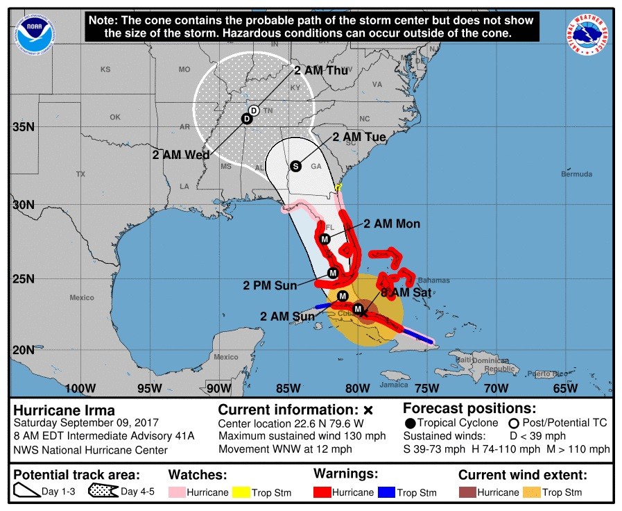
UPDATE 8 a.m. ET: Irma once again a Category 4 hurricane. Winds from within the storm have been reduced to 130 mph.
The National Hurricane Center’s latest advisory has the storm located at 22.6°N 79.6°W, moving west at 12 mph, 225 miles southeast of Miami.
Some of the key updates include the extension of watches and warnings by the National Hurricane Center:
SUMMARY OF WATCHES AND WARNINGS IN EFFECT:
A Storm Surge Warning is in effect for…
* Volusia/Brevard County Line southward around the Florida peninsula
to Chassahowitzka
* Florida Keys
* Tampa BayA Storm Surge Watch is in effect for…
* North of the Volusia/Brevard County Line to the Flagler/Volusia
County line
* North of Chassahowitzka to Suwannee RiverA Hurricane Warning is in effect for…
* Flagler/Volusia County Line southward around the Florida peninsula
to Chassahowitzka
* Florida Keys
* Lake Okeechobee
* Florida Bay
* Cuban provinces of Camaguey, Ciego de Avila, Sancti Spiritus,
Villa Clara, and Matanzas
* Northwestern BahamasA Hurricane Watch is in effect for…
* North of the Flagler/Volusia County Line to Fernandina Beach
* North and west of Chassahowitzka to Indian Pass
* Cuban provinces of Holguin and Las TunasA Tropical Storm Warning is in effect for…
* Cuban provinces of Holguin, Las Tunas, La Habana, and Ciudad de
la HabanaA Tropical Storm Watch is in effect for…
* North of Fernandina Beach to Altamaha Sound
Follow Jeff Poor on Twitter @jeff_poor
COMMENTS
Please let us know if you're having issues with commenting.